High Street, Fremantle
| High Street Western Australia | |
|---|---|
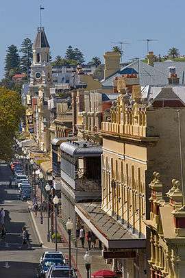 | |
| Looking east along High Street from the Roundhouse | |
| General information | |
| Type | Road |
| Length | 3.7 km (2.3 mi) |
| Route number(s) |
|
| Major junctions | |
| East end |
|
| |
| West end | Little High Street near The Round House, Fremantle |
| |
High Street is the main street running through the City of Fremantle, Western Australia.[1] The street passes by historic landmarks, including the Round House, the Fremantle Town Hall, and the Fremantle War Memorial, and through two town squares. Trams operated along High Street for 47 years, between 1905 and 1952. Running east–west, High Street continues as Leach Highway, a major arterial road, at Carrington Street, linking Fremantle with Perth Airport.
History
Within twelve years of Fremantle being settled in 1829, High Street was considered the main road of the area.[2] The street was named by the Surveyor-General of Western Australia John Septimus Roe,[3] in line with the traditional naming of main streets in England.[4] The east-west route linked the Round House at Arthur Head to Saint John's Church of England in Kings Square.[2] High Street was first paved in 1858 with Yorkshire flagstones, however initially only the northern side of the road was paved.[2] In 1881, the extension of High Street commenced after Saint John's Church sold land for the Fremantle Town Hall, and a right of way through Kings Square, to the Fremantle City Council.[2][5][6]
In the 1960s, High Street was closed to traffic and made into a pedestrian mall between Queen Street and Market Street. This was carried out as part of a traffic management plan for Fremantle, which reinstated Kings Square as a town square, and turned the streets around the square into a one way rotary.[6]
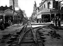
Trams
A plan for an electric tram network in Fremantle was submitted to the City Council in July 1897, that included routes along High Street.[7] However, there was some opposition to the plans from local residents.[8] The details of the tramway scheme was not finalised until June 1904.[9] The Fremantle and East Fremantle councils financed the project through a loan of 80,000 pounds.[10] The first trial runs of trams along High Street was on 30 September 1905,[11] with the system officially opening on 30 October 1905.[12] Trams operated along High Street[13] until 1952, when the trams in Fremantle were replaced by buses.[14][15][16][17] The trams were taken out of service due to their economic costs and to relieve traffic congestion on roads.[16][17] The last tram service operated was on 8 November 1952.[18][19]
Route description
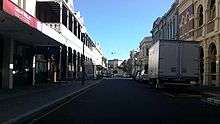
The street begins at the intersection of Leach Highway and Carrington Street, at Fremantle's eastern edge. It travels west as the continuation of State Route 7, meeting Stirling Highway after 1.4 kilometres (0.87 mi), at the highway's southern terminus. The road continues west for another 600 metres (2,000 ft), until it reaches Monument Hill at its intersection with East Street and Swanbourne Street. From there it turns south-west, reaching Ord Street after 300 metres (980 ft), which is the western terminus of State Route 7. High Street continues south-west, passing, after 400 metres (1,300 ft), through Queens Square,[20][21] a set of four squares around High Street's intersection with Parry Street. Another 230 metres (750 ft) along is Queen Street, the north-eastern edge of Kings Square.[20][22][23] High Street is a pedestrian mall through Kings square, and for another 100 metres (330 ft) west of the square, until Market Street. South-west from this point, the street is one-way for 400 metres (1,300 ft), until it reaches Cliff Street. The road's terminus is only 65 metres (213 ft) further along, at Little High Street, adjacent to the Round House.
Historic streetscape
High Street is lined by a significant number of heritage buildings between the Round House and where it becomes a pedestrian mall, at Market Street just west of the Fremantle Town Hall. The buildings include:
- 1 High Street – Fremantle Municipal Tramways Car Barn[24]
- 4 High Street – Union Bank
- 6 High Street – Hotel Fremantle[25]
- 7 High Street – Bank of New South Wales[26]
- 28-36 High Street – Adelec Buildings
- 35 High Street – Athena Lodge[27]
- 38-50 High Street – Marich Buildings
- 39 High Street – Orient Hotel[28]
- 41–47 High Street – Union Stores Building[29]
- 81–83 High Street – R.S.L. Club[30]
- 84 High Street – ANZ Bank Building[31]
- 98 High Street – National Hotel[32]
At the town hall the pedestrian mall is crossed by the intersection of Adelaide and William streets it then continues through Kings Square until it reaches Queen Street. The section of road through Kings Square is frequently used for festivals and markets. From Queens Street, High Street continues east until it abuts Leach Highway at Carrington street. Along this section of the road there are a number of further significant places including:
- 160 High Street – Dalkeith House[33]
- 177 High Street – Oriana Cinema
- 179 High Street – Victoria Hall[34]
- 186 High Street – Lenaville[35]
- 200 High Street – Fremantle Grammar School[36]
- High & Swanborne – Fremantle War Memorial[37]
- High & Carrington – Fremantle Cemetery[38]
Major intersections
-
 Leach Highway (State Route 7) east / Carrington Street
 -
 Stirling Highway (State Route 5) north
 - East Street north / Swanbourne Street south
-
 Ord Street (State Route 12)
 - Parry Street
- Queen Street
- Adelaide Street north-east / William Street south-east
- Market Street
- Cliff Street
- Little High Street
See also
![]() Australian Roads portal
Australian Roads portal
Notes
- ↑ "High-Street, Fremantle—.". Sunday Times. Perth: National Library of Australia. 15 February 1914. p. 1 Section: SECOND SECTION. Retrieved 7 November 2012.
- 1 2 3 4 "High St. marches with history.". Sunday Times. Perth: National Library of Australia. 21 March 1954. p. 19 Section: FIRST SECTION. Retrieved 19 November 2012.
- ↑ "HISTORICAL SOCIETY.". The West Australian. Perth: National Library of Australia. 1 June 1931. p. 11. Retrieved 10 November 2012.
- ↑ Ewers, John K. (1971). The Western Gateway: A History of Fremantle (2nd ed.). Nedlands, Western Australia: University of Western Australia Press for the Fremantle City Council. p. 223. ISBN 085564 050 2.
- ↑ "MUNICIPAL MEETING.". The Western Australian Times. Perth: National Library of Australia. 19 June 1877. p. 2. Retrieved 18 November 2012.
- 1 2 Ewers, John K. (1971). The Western Gateway: A History of Fremantle (2nd ed.). Nedlands, Western Australia: University of Western Australia Press for the Fremantle City Council. pp. 30, 184. ISBN 085564 050 2.
- ↑ "PROPOSED FREMANTLE TRAMWAYS.". The West Australian. Perth: National Library of Australia. 12 July 1897. p. 3. Retrieved 19 November 2012.
- ↑ "FREMANTLE ELECTRIC LIGHT AND TRAMWAY SCHEME.". The Daily News. Perth: National Library of Australia. 18 November 1899. p. 3. Retrieved 19 November 2012.
- ↑ "FREMANTLE TRAMWAYS AND ELECTRIC LIGHTING.". The West Australian. Perth: National Library of Australia. 9 June 1904. p. 7. Retrieved 19 November 2012.
- ↑ "FREMANTLE TRAMWAYS AND ELECTRIC LIGHTING.". The West Australian. Perth: National Library of Australia. 16 June 1904. p. 2. Retrieved 19 November 2012.
- ↑ "FREMANTLE TRAMS.". Sunday Times. Perth: National Library of Australia. 1 October 1905. p. 1. Retrieved 19 November 2012.
- ↑ "FREMANTLE WEEK.". The West Australian. Perth: National Library of Australia. 31 October 1905. p. 7. Retrieved 19 November 2012.
- ↑ Nixon, C. M (1900), High Street, Fremantle in 1929, retrieved 7 November 2012
- ↑ "VETERANS OF FREMANTLE TRAMWAYS.". The West Australian. Perth: National Library of Australia. 26 June 1952. p. 7. Retrieved 19 November 2012.
- ↑ "Port Switch To Buses.". The West Australian. Perth: National Library of Australia. 21 August 1952. p. 16. Retrieved 19 November 2012.
- 1 2 "BUSES REPLACING TRAMS AT PORT.". The West Australian. Perth: National Library of Australia. 17 May 1952. p. 4. Retrieved 19 November 2012.
- 1 2 "Port Soon To See Last of Its Trams.". The West Australian. Perth: National Library of Australia. 24 September 1952. p. 5. Retrieved 19 November 2012.
- ↑ "HISTORIC LINK Mayor Drives Last Tram.". Sunday Times. Perth: National Library of Australia. 9 November 1952. p. 24 Section: Sporting Section. Retrieved 19 November 2012.
- ↑ "Civic Farewell For Port's Last Tram". The West Australian. Perth: National Library of Australia. 10 November 1952. p. 6. Retrieved 19 November 2012.
- 1 2 Seddon, George (1994), "Fremantle's two squares", Historic Environment, 11 (1): 24–26, ISSN 0726-6715
- ↑ At some stage the four squares that make up Queen Square had been fenced and locked, none remain today "Fremantle Squares.". The Daily News. Perth: National Library of Australia. 4 August 1931. p. 6 Edition: Home (Final) Edition. Retrieved 7 November 2012.
- ↑ Kings Square north side had an Anglican church built on it in 1879 -"New church, Fremantle.". The Inquirer & Commercial News. Perth: National Library of Australia. 9 October 1878. p. 3. Retrieved 7 November 2012.
- ↑ For comments on King Square at the time of the demolition of building in the southern part of the square in 1929"An Historic Site.". The West Australian. Perth: National Library of Australia. 24 May 1929. p. 18. Retrieved 7 November 2012.
- ↑ "Fremantle Municipal Tramways Car Barn (fmr)". State Heritage Office – Government of Western Australia. 23 December 2011. Retrieved 19 November 2012.
- ↑ "Hotel Fremantle & residence (at rear)". State Heritage Office – Government of Western Australia. 23 December 2011. Retrieved 19 November 2012.
- ↑ "Bank of New South Wales (former), 7 High St, Fremantle, WA, Australia". Australian Heritage Database. Department of Sustainability, Environment, Water, Population and Communities. Retrieved 2 December 2012.
- ↑ "Athena Lodge (fmr)". State Heritage Office – Government of Western Australia. 5 November 2012. Retrieved 19 November 2012.
- ↑ "Orient Hotel". State Heritage Office – Government of Western Australia. 23 December 2011. Retrieved 19 November 2012.
- ↑ "Union Stores Building (fmr)". State Heritage Office – Government of Western Australia. 23 December 2011. Retrieved 19 November 2012.
- ↑ "R.S.L. Club". State Heritage Office – Government of Western Australia. 23 December 2011. Retrieved 19 November 2012.
- ↑ "ANZ Bank Building". State Heritage Office – Government of Western Australia. 5 November 2012. Retrieved 19 November 2012.
- ↑ "National Hotel". State Heritage Office – Government of Western Australia. 23 December 2011. Retrieved 19 November 2012.
- ↑ "Dalkeith House". State Heritage Office – Government of Western Australia. 23 December 2011. Retrieved 19 November 2012.
- ↑ "Victoria Hall". State Heritage Office – Government of Western Australia. 23 December 2011. Retrieved 19 November 2012.
- ↑ "Lenaville". State Heritage Office – Government of Western Australia. 23 December 2011. Retrieved 19 November 2012.
- ↑ "Fremantle Grammar School (fmr)". State Heritage Office – Government of Western Australia. 23 December 2011. Retrieved 19 November 2012.
- ↑ "FREMANTLE WAR MEMORIAL & MONUMENT HILL". State Heritage Office – Government of Western Australia. 23 December 2011. Retrieved 19 November 2012.
- ↑ "Fremantle Cemetery and Superintendent's Cottage". State Heritage Office – Government of Western Australia. 12 November 2012. Retrieved 19 November 2012.
- Route description
- Google (19 November 2012). "High Street, Fremantle" (Map). Google Maps. Google. Retrieved 19 November 2012.
| National Highways | ||||
|---|---|---|---|---|
| National Routes | ||||
| State Routes | ||||
| Tourist Drives | ||||
| Wikimedia Commons has media related to High Street, Fremantle. |