Highways in Estonia
Highways in Estonia are the main transport network in Estonia. The Estonian national classification includes several classes of highways:[1]
- Main route (põhimaantee) - highway, that connects the capital with other large cities, connects large cities and the capital with major ports, railway points and border crossings.
- Support route (tugimaantee) - highway, that connects towns with other towns and main routes.
- Side route (kõrvalmaantee) - highway, that connects towns with boroughs, connects boroughs and villages and all of the previous with main- and support routes.
Other than these, the national road classification includes the following categories which may also be referred to as highways in a general sense, with decreasing order of priority (and applicability of the term highway):
- Connector road (ühendustee) - constructed for traffic flow on the intersections/interchanges of highways
- other (muu) - other roads in the list of the Ministry of Economic Affairs and Communications
All roads in Estonia are officially marked with the prefix T (followed by 1-3 digits).
The technical classification of highways is as follows:[2]
- Motorway (kiirtee) - Paved highway designated for appropriately fast-traveling motor vehicles, that does not service areas directly adjacent to it. A motorway has at least two lanes in each traveling direction, separated physically. The road must intersect with railways or other roads on different levels. The road is entered and exited via acceleration and deceleration lanes. A road must confine to the motorway standards, when the expected AADT is 30 000.
- I class - Paved highway with at least two lanes in each traveling direction, that intersects with railways or other roads on different levels. The road is entered and exited via acceleration and deceleration lanes. A road must confine to the I class highway standards, when the expected AADT is 14 500.
- II class - Paved highway, which may intersect with other roads at-grade. A road must confine to the II class highway standards, when the expected AADT is 6 000.
- III class - Paved highway, which may intersect with other roads at-grade. A road must confine to the III class highway standards, when the expected AADT is 3 000.
- IV class - Paved or unpaved highway, which may intersect with other roads at-grade. A road must confine to the IV class highway standards, when the expected AADT is 500.
- V class - Paved or unpaved highway. A road must confine to the V class highway standards, when the expected AADT is 500.
- VI class - Paved or unpaved highway. A road must confine to the VI class highway standards, when the expected AADT is 50.
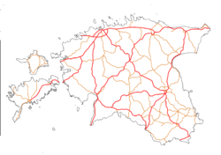
Main routes
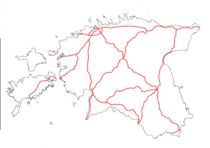
The backbone of the Estonian national route system, national main routes (põhimaanteed) make up a network of 1602 kilometres of road, amounting to 10% of the total road network. The traffic numbers however make up nearly 50% of the Estonian road network's traffic volumes. The highest AADT's are around Tallinn, on the T1 between Loo and Maardu, on the T2 between Tallinn and Jüri, and on the T4 between Laagri and Kanama (the highest AADT in Estonia at 31 A main route is defined as a highway, that connects the capital with other large cities, connects large cities and the capital with major ports, railway points and border crossings. Currently there are 12 separate main routes. The main routes are marked with 1-2 white digits on a red shield. The main roads have no special prefix, as all Estonian roads have the prefix T. The speed limits on Estonian main routes are 110 on 2+2 sections and 90 on regular roads.
The main routes are the only roads with I class highways. The total amount is 147 kilometres, found on the T1, T2, T4 and T11. This number will enlarge significantly with the upgrade of the T11 to I class highway. There are currently no motorways in Estonia, however there are plans to construct one between Kose and Mäo for 2022. Ten main routes are a part of TEN-T, six routes are a part of the International E-road network. The routes E263, E67, E20, E264 and E265 run through Estonia.
The highways are maintained by the Estonian Road Administration outside city limits. Inside cities and towns, the roads are maintained by the city government. The first stationary speed cameras in Estonia were placed on route T2. Currently there are 52 stationary speed cameras on the main routes.
List of main routes
| Route | County | Length | Description | Notes |
|---|---|---|---|---|
| Harjumaa, Lääne-Virumaa, Ida-Virumaa | 212.3 km (131.9 mi) | The T1 starts at Viru Väljak in Tallinn. The road passes through Tallinn, intersects with the T11 at Väo and proceeds east towards Rakvere. The route then continues east towards Jõhvi, Sillamäe and Narva, finally terminating in Narva at the Russian border. | I class highway for 77.6 kilometres. | |
| Harjumaa, Järvamaa, Jõgevamaa, Tartumaa, Põlvamaa, Võrumaa | 287.9 km (178.9 mi) | The T2 starts at Ülemiste in Tallinn. The road passes through Tallinn and proceeds south-east towards Jüri. Here the road intersects with the T11. The route then continues southeast towards Tartu, Võru and Luhamaa, finally terminating in Luhamaa at the T7. | I class highway for 44 kilometres. Plans to build new motorway section between Kose and Mäo. Longest highway in Estonia. | |
| Ida-Virumaa, Jõgevamaa, Tartumaa, Valgamaa | 219.6 km (136.5 mi) | The T3 starts at the T1 interchange in Jõhvi. The road passes through Jõhvi and proceeds southwest through Ahtme and towards Tartu. After Tartu the route continues southwest towards Elva and Valga, finally terminating in Valga at the Latvian border. | ||
| Harjumaa, Raplamaa, Pärnumaa | 192.2 km (119.4 mi) | The T4 starts at Viru Väljak in Tallinn. The road passes through Tallinn and proceeds south towards Pärnu. The route then continues south towards Märjamaa and Pärnu, finally terminating in Ikla at the Latvian border. | I class highway for 31.8 kilometres. | |
| Lääne-Virumaa, Järvamaa, Pärnumaa | 184.3 km (114.5 mi) | The T5 starts at the intersection with the T4 in Pärnu. The road proceeds northeast towards Paide. After intersecting with the T2 at Mäo, the route then continues northeast towards Tapa and Rakvere, finally terminating in Sõmeru at the T1. | I class highway for 1.8 kilometres. | |
| Pärnumaa, Viljandimaa, Valgamaa | 124.8 km (77.5 mi) | The T6 starts at the Latvian border in Valga. The road passes through Valga and proceeds northwest towards Tõrva. After Tõrva the route continues northwest towards Uulu finally terminating in Uulu at the T4. | ||
| Võrumaa | 22 km (14 mi) | The T7 starts at Misso at the Latvian border. The road shortly after passes through Misso and proceeds east towards Luhamaa. The route then intersects with the T2 and continues east towards the Russian border. | Shortest highway in Estonia. | |
| Harjumaa | 47.2 km (29.3 mi) | The T8 starts at Tallinn. The road passes through Tallinn, intersects with the T11 at Keila and proceeds west towards Paldiski. The route then terminates at Paldiski. | ||
| Harjumaa, Läänemaa | 81 km (50 mi) | The T9 starts at the interchange with the T4 in Ääsmäe. The road proceeds southwest towards Haapsalu. After intersecting with the T10 in Risti, the route continues west towards Haapsalu, finally terminating in Rohuküla port. | ||
| Harjumaa, Läänemaa, Saaremaa | 143.7 km (89.3 mi) | The T10 starts at the intersection with the T9 at Risti. The road proceeds southwest towards Virtsu port. The route includes a ferry crossing to Muhu island (Kuivastu port), shortly after crossing to Saaremaa via the Väinatamm causeway, after which it continues southwest towards Kuressaare, terminating there. | Only national route to include a ferry crossing. | |
| Harjumaa | 38.4 km (23.9 mi) | The T11 is Tallinn's ring road. The T11 starts at the intersection with the T1 at Väo. The road passes by Jüri, intersecting with the T2, by Luige, intersecting with the T15, by Saue, intersecting with the T4 and finally terminating at Keila, when intersecting with the T8. | I class highway for 8.9 kilometres. The entire section between Kanama and Väo will be upgraded to I class highway by 2020, with major construction works already ongoing. | |
| Tartumaa, Viljandimaa, Pärnumaa | 122.6 km (76.2 mi) | The T92 starts at the intersection with the T2 at Tartu. The road proceeds west towards Viljandi. After going through Viljandi, the route then continues west towards Kilingi-Nõmme, finally terminating in Väljaküla at the T6. |
Support routes
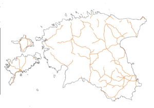
Support routes (tugimaanteed) are the second highest classification in the Estonian national route system. They make up a network of 2405 kilometres of road, amounting to 15% of the total road network. A support route is defined as a highway, that connects towns with other towns and main routes. Currently there are 77 separate support routes. The support routes are marked with 2 black digits on a orange shield. The support roads have no special prefix, as all Estonian roads have the prefix T.
List of support routes
| Route | Control cities (or other appropriate route description) | Length |
|---|---|---|
| Kose (T2), Jägala (T13) | 36.1 km (22.4 mi) | |
| Jägala (T1), Käravete (T5) | 52.7 km (32.7 mi) | |
| Kose (T2), Purila (T15) | 39.1 km (24.3 mi) | |
| Tallinn (T4), Rapla, Türi (T5) | 97.2 km (60.4 mi) | |
| Keila (T8), Haapsalu (T9) | 68.8 km (42.8 mi) | |
| Niitvälja (T8), Kulna (T17) | 4.7 km (2.9 mi) | |
| Põdruse (T1), Kunda, Pada (T1) | 28.3 km (17.6 mi) | |
| Rakvere, Luige (T36) | 69.6 km (43.2 mi) | |
| Rakvere (T5), Väike-Maarja, Vägeva (T39) | 52.0 km (32.3 mi) | |
| Rakvere (T5), Haljala (T1) | 8.3 km (5.2 mi) | |
| Tapa (T5), Loobu (T1) | 26.0 km (16.2 mi) | |
| Mäeküla (T2), Koeru, Kapu (T39) | 25.3 km (15.7 mi) | |
| Türi (T5), Arkma (T49) | 21.2 km (13.2 mi) | |
| Rapla, Järvakandi, Kergu (T58) | 40.8 km (25.4 mi) | |
| Rapla, Märjamaa (T4) | 21.6 km (13.4 mi) | |
| Märjamaa (T4), Koluvere (T10) | 25.1 km (15.6 mi) | |
| Haapsalu (T9), Laiküla (T10) | 36.0 km (22.4 mi) | |
| Jõhvi (T1), Vasknarva | 49.9 km (31.0 mi) | |
| Jõhvi (T3), Kose (T32) | 3.6 km (2.2 mi) | |
| Varja (T1), Kiviõli | 8.7 km (5.4 mi) | |
| Iisaku, Tudulinna, Avinurme (T21) | 33.5 km (20.8 mi) | |
| Jõgeva, Mustvee | 38.9 km (24.2 mi) | |
| Jõgeva, Põltsamaa | 26.1 km (16.2 mi) | |
| Põltsamaa, Võhma (T49) | 27.6 km (17.1 mi) | |
| Tartu (T3), Jõgeva, Aravete (T5) | 108.0 km (67.1 mi) | |
| Tartu (T3), Tiksoja (T2) | 7.0 km (4.3 mi) | |
| Kärevere (T2), Kärkna (T39) | 12.9 km (8.0 mi) | |
| Kärkna (T39), Kobratu (T3) | 7.1 km (4.4 mi) | |
| Aovere (T3), Kallaste, Kasepää (T3) | 57.0 km (35.4 mi) | |
| Aovere (T43), Luunja (T45) | 11.4 km (7.1 mi) | |
| Tartu (T3), Räpina, Värska | 85.5 km (53.1 mi) | |
| Tatra (T2), Otepää, Sangaste (T69) | 46.6 km (29.0 mi) | |
| Sangla (T92), Rõngu (T52) | 22.4 km (13.9 mi) | |
| Imavere (T2), Viljandi, Karksi-Nuia (T6) | 82.1 km (51.0 mi) | |
| Aindu (T49), Viljandi (T92) (also known as Viljandi road) | 4.4 km (2.7 mi) | |
| Viljandi, Põltsamaa (T38) | 43.4 km (27.0 mi) | |
| Viljandi, Rõngu (T3) | 61.1 km (38.0 mi) | |
| Ojaperve (T49), Viiratsi (T52) (also known as Laidu road) | 3.6 km (2.2 mi) | |
| Karksi-Nuia (T6), Lilli, border with Latvia |
17.0 km (10.6 mi) | |
| Kamara (T6), Mõisaküla, border with Latvia |
4.4 km (2.7 mi) | |
| Mudiste (T49), Suure-Jaani, Vändra (T5) | 42.8 km (26.6 mi) | |
| Aluste (T5), Kergu (T27) | 12.2 km (7.6 mi) | |
| Pärnu (T4), Tori (T5) | 23.5 km (14.6 mi) | |
| Pärnu (T4), Lihula (T10) | 56.1 km (34.9 mi) | |
| Põlva, Reola (T2) | 37.1 km (23.1 mi) | |
| Kanepi (T2), Leevaku (T45) | 41.8 km (26.0 mi) | |
| Karisilla (T45), Koidula border checkpoint with Russia |
17.8 km (11.1 mi) | |
| Võru, Põlva | 24.7 km (15.3 mi) | |
| Võru, Räpina | 44.0 km (27.3 mi) | |
| Võru , Verijärve (T2) | 6.5 km (4.0 mi) | |
| Võru, Mõniste, Valga | 83.3 km (51.8 mi) | |
| Mõniste (T67), border with Latvia |
8.9 km (5.5 mi) | |
| Võru (T2), Kuigasti, Tõrva (T6) | 71.3 km (44.3 mi) | |
| Antsla, Vaabina (T69) | 6.9 km (4.3 mi) | |
| Rõngu (T3), Otepää, Kanepi (T2) | 39.3 km (24.4 mi) | |
| Sangaste (T69), Tõlliste (T3) | 16.6 km (10.3 mi) | |
| Tõrva (T6), Pikasilla (T52) | 12.0 km (7.5 mi) | |
| Tumala (T10), Orissaare, Väinatamm causeway (T10) | 8.3 km (5.2 mi) | |
| Kuressaare ring road | 13.5 km (8.4 mi) | |
| Kuressaare, Sääre | 47.4 km (29.5 mi) | |
| Kuressaare, Kihelkonna, Veere | 47.8 km (29.7 mi) | |
| Upa (T10), Leisi | 36.8 km (22.9 mi) | |
| Heltermaa port, Kärdla, Luidja (T84) | 50.2 km (31.2 mi) | |
| Kärdla, Käina (T83) | 21.7 km (13.5 mi) | |
| T80, Lehtma port (also known as Lehtma port road) | 7.0 km (4.3 mi) | |
| Suuremõisa (T80), Käina, Emmaste | 31.2 km (19.4 mi) | |
| Emmaste (T83), Luidja (T80) | 29.9 km (18.6 mi) | |
| Liiapeksi (T1), Loksa | 15.5 km (9.6 mi) | |
| Kuressaare, Võhma, Panga | 36.8 km (22.9 mi) | |
| Põlva ring road | 6.0 km (3.7 mi) | |
| Rakvere, Rannapungerja (T3) | 70.8 km (44.0 mi) | |
| Põlva, Saverna (T2) | 20.4 km (12.7 mi) | |
| Põlva, Karisilla (T45) | 34.2 km (21.3 mi) | |
| Narva (T1), Narva-Jõesuu, Hiiemetsa (T1) | 26.3 km (16.3 mi) | |
| Kohtla-Järve, Kukruse, Tammiku (T3) | 15.6 km (9.7 mi) | |
| Liivamäe (T1), Muuga container port (also known as Muuga port road) | 3.4 km (2.1 mi) | |
| Kõrveküla (T3), Tartu | 1.9 km (1.2 mi) |
European routes

Estonia is a part of the UNECE, and therefore also has numerous E-roads running through it. The E-roads in Estonia form a network on top of the main routes and are usually signposted on all signs. They make up a network of 994 kilometres of road. Currently there are 6 separate European routes in Estonia.
List of European routes
| Route | Estonian route | Control cities | Length |
|---|---|---|---|
| Tallinn, Narva | 212.3 km (131.9 mi) | ||
| Tallinn, Pärnu, Ikla | 192.2 km (119.4 mi) | ||
| Luhamaa border checkpoint, Misso border crossing | 22.0 km (13.7 mi) | ||
| Tallinn, Tartu, Võru, Luhamaa | 287.9 km (178.9 mi) | ||
| Jõhvi, Tartu, Valga | 219.6 km (136.5 mi) | ||
| Tallinn ring road, Paldiski | 60.4 km (37.5 mi) |
See also
References
| Wikimedia Commons has media related to National roads in Estonia. |