Hilderstone
| Hilderstone | |
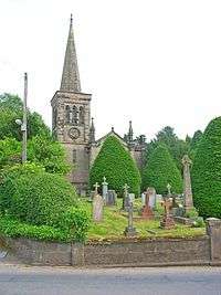 The Parish Church of Christ Church |
|
 Hilderstone |
|
| Population | 641 |
|---|---|
| – London | 150 miles |
| District | Stafford |
| Shire county | Staffordshire |
| Region | West Midlands |
| Country | England |
| Sovereign state | United Kingdom |
| Post town | Stone |
| Postcode district | ST15 |
| Dialling code | 01889 |
| Police | Staffordshire |
| Fire | Staffordshire |
| Ambulance | West Midlands |
| EU Parliament | West Midlands |
|
|
Coordinates: 52°54′33″N 2°04′40″W / 52.90925°N 2.07774°W
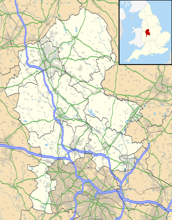
Hilderstone is a village and a civil parish in the English county of Staffordshire.[1][2]
Location
The village is 8.6 miles (13.8 km) north of the town of Stafford, and 9.8 miles (15.8 km) south east of Stoke on Trent. The nearest railway station is 5.3 miles (8.5 km) west in the town of Stone. The village is situate on the B 5066. The nearest main roads are the A520 which passes the village 3.8 miles (6.1 km) to the west.[3]
Population
The 2011 census recorded a population of 641[4] in 235 Households. The parish comes under the Stafford Non-Metropolitan District.
History
Etymology
The genesis of the village name are said to be of Saxon origin.[5] The name Heldulvestone and its variant are of Saxon derivation. The origin of Hilderstone is Hildewulf’s ton meaning a warrior wolf and ton a place or town. Thus Hilderstone was the place of the warrior wolf.
Domesday Book
Hilderstone is listed in the Domesday Book of 1086. In the survey the village has the name Heldulvestone[6] In the survey the settlement was described as quite small with only 6 households. Other Assets included 2 villager or villein, meadow of 1 acres, 2 smallholders and 2 slave. There was also 3 ploughlands (land for), 1 lord's plough teams, 1 men's plough teams. In 1066 the lord of the manor was held by Wulfric Dunning. In 1086 the lord of the manor was held by Vitalis of Hilderstone. The Tenant-in-chief in 1086 was Robert of Stafford.[7]
Buildings and Structures
There are 16 listed buildings and structures within the parish. This includes a K6 Telephone Box designed in 1935 by Sir Giles Gilbert Scott. All of these structures have been designated a Grade II listing.
Listed Buildings in Hilderstone
The parish church of Christ Church
The Grade II listed[19] parish church of Christ Church[20] began construction in 1829 with the laying of a foundation stone. The church was designed by architect Thomas Trubshaw (1802–42) and was built using a local stone called Hollington stone.[21] Trubshaw was a son of James Trubshaw, the head of a Staffordshire family of masons and church builders who had been involved in church building for many years. This church was designed and built in the gothic style. The structure is 72.0 feet (21.9 m) in length and has a central aisle and two side aisles. The church is 32.0 feet (9.8 m) at its widest. There is 40.0 feet (12.2 m) tall tower with a recessed spire at the north west with a single bell.[22] Around the outside eaves of the church there are carved gargoyles which are said to depict the workmen involved in the building of the church. The church was completed in 1833 and opened on 31 July of that year.
| Wikimedia Commons has media related to Hilderstone, Staffordshire. |
References
- ↑ OS Explorer Map 244: Cannock Chase & Chasewater: (1:25 000) :ISBN 0 319 46269 2
- ↑ Map Details retrieved 11 April 2013
- ↑ - Staffordshire A-Z County Atlas: 2011 Edition: Scale:3.8 inches to 1 mile (5.9cm to 1km) ISBN 978 1 84348 748 7
- ↑ "Census population and household counts for parish of Hilderstone" (Neighbourhood Statistics webpage). Office for National Statistics Census (2011). Retrieved 19 April 2013.
- ↑ Staffordshire Place Names Including The Black Country – Hilderstone:Author: Anthony Poulton-Smith: Publisher: Countryside Books (1995): ISBN 1853063614
- ↑ The Domesday Book, Englands Heritage, Then and Now, Editor: Thomas Hinde, Staffordshire Section, Hilderstone: ISBN 1858334403
- ↑ "Hilderstone" (by Anna Powell-Smith. Domesday data created by Professor J.J.N. Palmer, University of Hull.). Open Domesday. Retrieved 19 April 2013.
- 1 2 Barn Listings retrieved 21 April 2013
- ↑ Church Farmhouse Listings retrieved 21 April 2013
- ↑ Churchyard structures Listings retrieved 21 April 2013
- ↑ Shop and Copes Cottage Listings retrieved 21 April 2013
- ↑ Hilderstone Hall Listings retrieved 21 April 2013
- ↑ Hilderstone House Listings retrieved 21 April 2013
- 1 2 3 Horseshoe House & Cottages Listings retrieved 21 April 2013
- ↑ Stones Throw Listing retrieved 21 April 2013
- ↑ Smithy & School house Listing retrieved 21 April 2013
- ↑ The Stores Listing retrieved 21 April 2013
- ↑ Yew Tree House Listing ] retrieved 21 April 2013
- ↑ Christ Church Listings retrieved 20 April 2013
- ↑ "Christ Church" (The Hilderstone Website). The Hilderstone community website. Retrieved 20 April 2013.
- ↑ "Staffordshie Stone" (Staffordshire Stone Website). Staffordshire Stone, Quarry Bank, Hollington, Staffordshire – Hollington Stone. Retrieved 20 April 2013.
- ↑ Staffordshire (The Buildings of England): Author: Nikolaus Pevsner: Publisher: Pevsner Architectural Guides; 1st edition (27 May 1976): ISBN 0140710469