Quito
| Quito | |||
|---|---|---|---|
| Capital city | |||
| San Francisco de Quito | |||
|
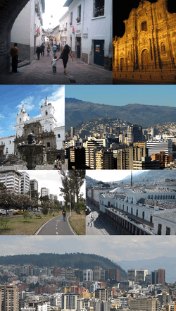
Clockwise from top: Calle La Ronda, Iglesia de la Compañía de Jesús, El Panecillo as seen from Northern Quito, Carondelet Palace, Central-Northern Quito, Parque La Carolina and Iglesia y Monasterio de San Francisco | |||
| |||
| Nickname(s): Luz de América (Light of America), Carita de Dios (God's Face), Ciudad de los Cielos (City of the heavens) | |||
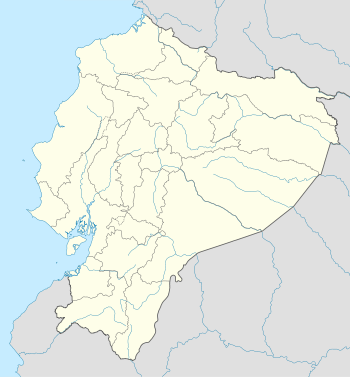 Quito Location of Quito within Ecuador | |||
| Coordinates: 00°14′S 78°31′W / 0.233°S 78.517°WCoordinates: 00°14′S 78°31′W / 0.233°S 78.517°W | |||
| Country | Ecuador | ||
| Province | Pichincha | ||
| Canton | Quito | ||
| Foundation | December 6, 1534 | ||
| Founded by | Sebastián de Belalcázar | ||
| Named for | Quitu | ||
| Urban parishes |
32 urban parishes
| ||
| Government | |||
| • Type | Mayor and council | ||
| • Governing body | Municipality of Quito | ||
| • Mayor | Mauricio Rodas Espinel | ||
| Areaapprox. | |||
| • Capital city | 372.39 km2 (143.78 sq mi) | ||
| • Water | 0 km2 (0 sq mi) | ||
| • Metro | 4,217.95 km2 (1,628.56 sq mi) | ||
| Elevation | 2,850 m (9,350 ft) | ||
| Population (2011) | |||
| • Capital city | 2,671,191 | ||
| • Density | 7,200/km2 (19,000/sq mi) | ||
| • Metro | 4,700,000 | ||
| • Metro density | 1,100/km2 (2,900/sq mi) | ||
| • Demonym | Quiteño(-a) | ||
| Time zone | ECT (UTC-5) | ||
| Postal code | EC1701 (new format), P01 (old format) | ||
| Area code(s) | (0)2 | ||
| Climate | Cfb | ||
| Website |
www | ||

Quito (Spanish pronunciation: [ˈkito]), formally San Francisco de Quito, is the capital city of Ecuador, and at an elevation of 2,850 metres (9,350 ft) above sea level, it is the highest official capital city in the world and the one which is closest to the equator.[1] It is located in the Guayllabamba river basin, on the eastern slopes of Pichincha,[2] an active stratovolcano in the Andes mountains. With a population of 2,671,191 according to the last census (2014), Quito is the second most populous city in Ecuador, after Guayaquil. It is also the capital of the Pichincha province and the seat of the Metropolitan District of Quito. The canton recorded a population of 2,239,191 residents in the 2010 national census. In 2008, the city was designated as the headquarters of the Union of South American Nations.[3]
The historic center of Quito has one of the largest, least-altered and best-preserved historic centers in the Americas.[4] Quito and Kraków, Poland, were the first World Cultural Heritage Sites declared by UNESCO, in 1978.[4] The central square of Quito is located about 25 kilometres (16 mi) south of the equator; the city itself extends to within about 1 kilometre (0.62 mi) of zero latitude. A monument and museum marking the general location of the equator is known locally as la mitad del mundo (the middle of the world), to avoid confusion, as the word ecuador is Spanish for equator.[5]
History
Pre-Columbian period
Quito's origins date back to the first millennium, when the Quitu tribe occupied the area and eventually formed a commercial center. According to Juan de Velasco's 1767 book Historia del Reino de Quito, the Quitu were conquered by the Caras tribe, who founded the Kingdom of Quito about 980 AD. For more than four centuries, Quito was ruled under the kings (shyris).
Caras and their allies were narrowly defeated in the epic battles of Tiocajas and Tixán in 1462, by an army of 250,000 led by Túpac Inca, the son of the Emperor of the Incas. After several decades of consolidation, the Kingdom of Quito became integrated into the Incan Empire. In 1534, the Caras/Quitu people were conquered by the Spanish.
Colonial period
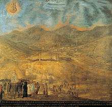

Indigenous resistance to the Spanish invasion continued during 1534, with the conquistador Diego de Almagro founding Santiago de Quito (in present-day Colta, near Riobamba) on August 15, 1534, later to be renamed San Francisco de Quito on August 28, 1534. The city was later moved to its present location and was refounded on 6 December 1534 by 204 settlers led by Sebastián de Benalcázar, who captured Rumiñahui and effectively ended any organized resistance.[6] Rumiñahui was then executed on January 10, 1535.
On March 14, 1541, Quito was declared a city and on February 14, 1556, was given the title Muy Noble y Muy Leal Ciudad de San Francisco de Quito ("Very Noble and Loyal City of San Francisco of Quito"), starting at this point its urban evolution. In 1563, Quito became the seat of a Real Audiencia (administrative district) of Spain and became part of the Viceroyalty of Peru, until 1717 after the Audiencia was part of a newly created Viceroyalty of Nueva Granada. Its administration on both Viceroyalties remained to Quito. (see Real Audiencia de Quito)
As with other places colonized by the Spanish, the colonizers promptly established Roman Catholicism in Quito. The first church (El Belén) was in fact built even before the city had been officially founded. In January 1535, the San Francisco Convent was constructed, the first of about 20 churches and convents built during the colonial period. The Spanish converted the indigenous population to Christianity and used them as labor for construction.
In 1743, after nearly 300 years of Spanish colonization, Quito was a city of about 10,000 inhabitants. On August 10, 1809, an independence movement from Spanish domination started in Quito. On that date, a plan for government was established that placed Juan Pío Montúfar as president with various other prominent figures in other positions of government. However, this initial movement was ultimately defeated on August 2, 1810, when colonial troops came from Lima, Peru, killing the leaders of the uprising along with about 200 settlers. A chain of conflicts concluded on May 24, 1822, when Antonio José de Sucre, under the command of Simón Bolívar, led troops into the Battle of Pichincha. Their victory marked the independence of Quito and the surrounding areas.
Republican Ecuador
In 1833, members of the Society of Free Inhabitants of Quito were assassinated by the government after they conspired against it, and on March 6, 1845, the Marcist Revolution began. Later, in 1875, the country's president, Gabriel García Moreno, was assassinated in Quito. Two years later, in 1877, Archbishop José Ignacio Checa y Barba was killed by poisoning while he was celebrating Mass.
In 1882, insurgents arose against the regime of dictator Ignacio de Veintimilla. However, this did not end the violence that was occurring throughout the country. On July 9, 1883, the liberal commander Eloy Alfaro participated in the Battle of Guayaquil, and later, after more conflict, became the president of Ecuador on September 4, 1895. Upon completing his second term in 1911, he moved to Europe. When he returned to Ecuador in 1912 and attempted a return to power, he was arrested on January 28, 1912; thrown in prison; and assassinated by a mob that had stormed the prison. His body was dragged through the streets of Quito to a city park, where it was burned.
In 1932, the Four Days' War broke out. This was a civil war that followed the election of Neptalí Bonifaz and the subsequent realization that he carried a Peruvian passport. On February 12, 1949, a realistic broadcast of H. G. Wells' novel The War of the Worlds led to citywide panic and the deaths of more than twenty people who died in fires set by mobs.[7]
21st century
In 2011, the city's population was 2,239,191 people. Since 2002, the city has begun renewing its historical center and also demolished the old airport and built a new Mariscal Sucre International Airport located 45 minutes from central Quito.
Between 2003 and 2004, the ecologically friendly bus lines of the Metrobus (Ecovia) were constructed, traversing the city from the north to the south. Many avenues and roads were extended and enlarged, depressed passages were constructed, and roads were restructured geometrically to increase the flow of traffic. A new subway system is currently under construction.
Geography

Quito is located in the northern highlands of Ecuador in the Guayllabamba river basin. The city is built on a long plateau lying on the east flanks of the Pichincha volcano. The valley of Guayllabamba River where Quito lies is flanked by volcanoes, some of them snow-capped, and visible from the city on a clear day. Quito is the closest capital city to the equator. Quito’s altitude is listed at 2,820 metres (9,250 feet).[8]
Nearby volcanoes
Quito's closest volcano is Pichincha, looming over the western side of the city. Quito is also the only capital in the world to be directly menaced by an active volcano.[9] Pichincha volcano has several summits, among them Ruku Pichincha at 4,700 metres (15,400 feet) above sea level and Wawa Pichincha at 4,794 metres (15,728 feet). Wawa Pichincha is active and being monitored by volcanologists at the geophysical institute of the national polytechnic university. The largest eruption occurred in 1660 when more than 25 cm (9.8 in) of ash covered the city.[10] There were three minor eruptions in the 19th century. The latest eruption was recorded on October 5, 1999, when a few puffs of smoke and a large amount of ash were deposited on the city.[11]
Activity in other nearby volcanoes also can affect the city. In November 2002, after an eruption in the volcano Reventador, the city was showered with a layer of fine ash particles to a depth of several centimeters.[12]
The volcanoes on the Central Cordillera (Royal Cordillera), east of Quito, surrounding the Guayllabamba valley include Cotopaxi, Sincholagua, Antisana and Cayambe. Some of the volcanoes of the Western Cordillera, to the west of the Guayllabamba valley, as well as are Pichincha include Illiniza, Atacazo, and Pululahua (which has the Pululahua Geobotanical Reserve).[13]
Climate
Under the Köppen climate classification, Quito has a subtropical highland climate[14] (Cfb).[15] Because of its elevation and its closeness to the equator, Quito has a fairly constant cool climate. The average temperature at noon is 18.7 °C (65.7 °F) with a normal night-time low of 9.3 °C (48.7 °F).[16] The annual average temperature is 14 °C (57 °F).[17] The city has only two seasons: dry and wet. The dry season, June through September (4 months), is referred to as summer; the wet season, October through May (8 months), is referred to as winter. Annual precipitation, depending on location, is about 1,000 mm (39 in).
Because of its elevation, Quito receives some of the greatest solar radiation in the world, sometimes reaching 24 in the UV Index.[18][19]
The fact that Quito lies almost on the equator means that high pressure systems are extremely rare. Pressure is stable, so very low pressure systems are also rare. From July 1, 2010 to June 30, 2011, the lowest pressure recorded was 998.2 hpa, and the highest was 1015.2 hpa. Despite the absence of high pressure, Quito can still experience settled weather. Generally, the highest pressure is around midnight and the lowest in the mid-afternoon.[20]
| Climate data for Quito | |||||||||||||
|---|---|---|---|---|---|---|---|---|---|---|---|---|---|
| Month | Jan | Feb | Mar | Apr | May | Jun | Jul | Aug | Sep | Oct | Nov | Dec | Year |
| Record high °C (°F) | 33.0 (91.4) |
28.6 (83.5) |
32.0 (89.6) |
25.6 (78.1) |
30.4 (86.7) |
29.0 (84.2) |
31.0 (87.8) |
27.0 (80.6) |
29.0 (84.2) |
27.0 (80.6) |
29.3 (84.7) |
29.0 (84.2) |
33.0 (91.4) |
| Average high °C (°F) | 21.2 (70.2) |
21.0 (69.8) |
20.8 (69.4) |
20.9 (69.6) |
21.0 (69.8) |
21.1 (70) |
21.5 (70.7) |
22.2 (72) |
22.3 (72.1) |
21.8 (71.2) |
21.3 (70.3) |
21.3 (70.3) |
21.4 (70.5) |
| Daily mean °C (°F) | 15.5 (59.9) |
15.6 (60.1) |
15.5 (59.9) |
15.6 (60.1) |
15.6 (60.1) |
15.5 (59.9) |
15.5 (59.9) |
15.9 (60.6) |
15.9 (60.6) |
15.7 (60.3) |
15.5 (59.9) |
15.5 (59.9) |
15.6 (60.1) |
| Average low °C (°F) | 9.8 (49.6) |
10.1 (50.2) |
10.1 (50.2) |
10.2 (50.4) |
10.1 (50.2) |
9.8 (49.6) |
9.4 (48.9) |
9.6 (49.3) |
9.4 (48.9) |
9.5 (49.1) |
9.6 (49.3) |
9.7 (49.5) |
9.8 (49.6) |
| Record low °C (°F) | 3.0 (37.4) |
4.7 (40.5) |
5.1 (41.2) |
5.3 (41.5) |
2.5 (36.5) |
3.0 (37.4) |
3.0 (37.4) |
2.2 (36) |
3.4 (38.1) |
4.2 (39.6) |
2.5 (36.5) |
2.5 (36.5) |
2.2 (36) |
| Average precipitation mm (inches) | 82.5 (3.248) |
111.0 (4.37) |
146.6 (5.772) |
171.2 (6.74) |
105.5 (4.154) |
39.5 (1.555) |
21.5 (0.846) |
27.7 (1.091) |
68.9 (2.713) |
114.9 (4.524) |
108.5 (4.272) |
100.4 (3.953) |
1,098.2 (43.236) |
| Average precipitation days (≥ 1.0 mm) | 10 | 11 | 15 | 15 | 13 | 7 | 5 | 5 | 11 | 14 | 11 | 11 | 128 |
| Mean monthly sunshine hours | 197 | 140 | 122 | 136 | 164 | 189 | 249 | 256 | 196 | 177 | 197 | 215 | 2,238 |
| Source #1: World Meteorological Organization[21] | |||||||||||||
| Source #2: NOAA[22][23] World Meteorological Organization (precipitation data),[24] Voodoo Skies (records)[25] | |||||||||||||
Topographical zones


Quito is divided into three areas, separated by hills:
- Central: houses the colonial old city.
- Southern: is mainly industrial and residential, and a working-class housing area.
- Northern: is the modern Quito, with high-rise buildings, shopping centers, the financial district, and upper-class residential areas and some working-class housing areas.
Economy
Quito is the largest city in contribution to national GDP, and the second highest in per capita income after Cuenca. Quito has the highest level of tax collection in Ecuador, exceeding the national 57% per year 2009, currently being the most important economic region of the country, 63 as the latest "study" conducted by the Central Bank of Ecuador.
The top major industries in Quito includes textiles, metals and agriculture, with major crops for export being coffee, sugar, cacao, rice, bananas and palm oil. [26]
TAME, an airline of Ecuador, has its headquarters in Quito.[1]
Petroecuador, the largest company in the country and one of the largest in Latin America is headquartered in Quito.[2]
Headquarters and regional offices of many national and international financial institutions, oil corporations and international businesses are also located in Quito, making it a world class business city.
In "The World according to GaWC global cities report which measures a city's integration into the world city network, Quito is ranked as a Beta city, as an important world class metropolis which is instrumental in linking it's region or state into the world economy. [27]
Politics
Governance
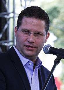
Quito is governed by a mayor and a 15-member city council. The mayor is elected to a five-year term and can be re-elected. The position also doubles as Mayor of the Metropolitan District of Quito (the canton). The current mayor is Mauricio Rodas.

Urban parishes
In Ecuador, cantons are subdivided into parishes, so called because they were originally used by the Catholic Church, but with the secularization and liberalization of the Ecuadorian state, the political parishes were spun off the ones used by the church. Parishes are called urban if they are within the boundaries of the seat (capital) of their corresponding canton, and rural if outside those boundaries. Inside Quito (the city proper), subdivision into urban parishes depends on the organizations that use these parishes (e.g., the municipality, the electoral tribunals, the postal service, the Ecuadorian statistics institute). The urban parishes of different types are not necessarily coterminous nor the same in number or name.
As of 2008, the municipality of Quito divided the city into 32 urban parishes. These parishes, which are used by the municipality for administrative purposes, are also known as cabildos[28] since 2001. Since the times of the Metropolitan District of Quito, parishes of this type are also grouped into larger divisions known as municipal zones (zonas municipales). These parishes are as follows:
- Belisario Quevedo
- Carcelén
- Centro Histórico
- Chilibulo
- Chillogallo
- Chimbacalle
- Cochapamba
- Comité del Pueblo
- Concepción
- Cotocollao
- El Condado
- El Inca
- Guamaní
- Iñaquito
- Itchimbía
- Jipijapa
- Kennedy
- La Argelia
- La Ecuatoriana
- La Ferroviaria
- La Libertad
- La Mena
- Magdalena
- Mariscal Sucre
- Ponceano
- Puengasí
- Quitumbe
- Rumipamba
- San Bartolo
- San Juan
- Solanda
- Turubamba
Ecclesiastical parishes
The Roman Catholic Archdiocese of Quito divides the city into 167 parishes, which are grouped into 17 zones.[29]
Transportation
Public transport
The MetrobusQ network, also known as "Red Integrada de Transporte Público", is the bus rapid transit system running in Quito, and it goes through the city from south to north. It's divided into three sections—the green line (the central trolleybus, known as El Trole), the red line (the north-east Ecovía), and the blue line (the north-west Corridor Central). In addition to the bus rapid transit system, there are many buses running in the city. The buses have both a name and a number, and they have a fixed route. Taxi cabs are all yellow, and they have meters that show the fare. There are nearly 8,800 registered taxicabs.[30]

In August 2012 the Municipality of Quito government established a municipal bicycle sharing system called Bici Q.[31][32][33]
Road transport
Although public transportation is the primary form of travel in the city, including fleets of taxis that constantly cruise the roadways, the use of private vehicles has increased substantially during the past decade.[34] Because of growing road congestion in many areas, there were plans to construct a light rail system, which were conceived to replace the northern portion of the Trole.[35] These plans have been ruled out and replaced by the construction of the first metro line (subway) in 2012. It is expected to be operational by 2016, joining the existing public transportation network.
Roads, avenues and streets Because Quito is about 40 km (25 mi) long and 5 km (3.1 mi) at its widest, most of the important avenues of the city extend from north to south. The two main motorways that go from the northern part of the city to the southern are Avenue Oriental (Corridor Periférico Oriental) on the eastern hills that border the city, and Avenue Occidental on the western side of the city on the Pichincha volcano. The street 10 de Agosto also runs north to south through most of the city, running down the middle of it. The historic centre of the city is based on a grid pattern, despite the hills, with the streets Venezuela, Chile, García Moreno, and Guayaquil being the most important.
Air transport

Mariscal Sucre International Airport serves as the city's principal airport for passenger travel and freight. The airport is located 18 kilometres (11 mi) east of the city's center in the Tababela parish. It began operations on February 20, 2013, replacing the Old Mariscal Sucre International Airport located 10 kilometres (6.2 mi) north of the city center within city limits. The old airport was replaced due to tall buildings and nighttime fog that made landing from the south difficult. The old airport has become a metropolitan park.
Rail
There is a railroad that goes through the southern part of Quito and passes through the Estación de Chimbacalle. It is managed by the Empresa de Ferrocarriles Ecuatorianos (EFE). This form of transport is nowadays used mostly for tourism.
Subway
A major construction project began in 2012 for a 23 kilometres (14 mi) metro subway system in Quito. Phase 1, currently underway, entails the construction of stations at La Magdalena and El Labrador. Phase 2 will involve 13 more stations, a depot and sub-systems. The project is expected to carry 400,000 passengers per day and to cost USD$1.5 billion with finance coming from the World Bank, the Inter-American Development Bank (IDB), the European Investment Bank (EIB) and the Development Bank of Latin America (CAF).[36]
Points of interest
Historic center
| City of Quito | |
|---|---|
| Name as inscribed on the World Heritage List | |
 | |
| Type | Cultural |
| Criteria | ii, iv |
| Reference | 2 |
| UNESCO region | Latin America and the Caribbean |
| Inscription history | |
| Inscription | 1978 (2nd Session) |
Quito has the largest, least-altered, and best-preserved historic center in the Americas.[4] This center was, together with the historic centre of Kraków in Poland, the first to be declared World Heritage Site by UNESCO on 18 September 1978. The Historic Centre of Quito is located in the center south of the capital on an area of 320 hectares (790 acres), and is considered one of the most important historic areas in Latin America.There are about 130 monumental buildings (which host a variety of pictorial art and sculpture, mostly religion inspired, in a multi-faceted range of schools and styles) and 5,000 properties registered in the municipal inventory of heritage properties.
- Carondelet Palace
Carondelet Palace (Spanish: Palacio de Carondelet) is the seat of government of the Republic of Ecuador, located in the historical center of Quito. The palace is in the nerve center of the public space known as Independence Square or Plaza Grande (colonial name), around which were built in addition the Archbishop's Palace, the Municipal Palace, the Hotel Plaza Grande and the Metropolitan Cathedral. During the Republican era, almost all the presidents (constitutional, internees and dictators) have dispatched from this building, which is the seat of Government of the Republic of Ecuador. In addition to the administrative units in the third level of the Palace is the presidential residence, a luxurious colonial-style apartment in which the President and his family dwell. Rafael Correa, president since 2007, converted the presidential compound into a museum accessible to all who wish to visit it.
- Basilica del Voto Nacional
This monumental Basilica del Voto Nacional is the most important neo-Gothic building in Ecuador and one of the most representative of the American continent. It was once the largest in the New World.
- Cathedral of Quito
The Cathedral of Quito, is one of the largest religious symbols of spiritual value for the Catholic community in the city. This church began its construction in 1562, seventeen years after the diocese of Quito was created (1545). The church building was completed in 1806, during the administration of President of the Real Audiencia Baron Héctor de Carondelet.
One of the events that took place in this cathedral was the murder of the Bishop of Quito, José Ignacio Checa y Barba, who during the mass of Good Friday on 30 March 1877 was poisoned with strychnine dissolved in the consecrated wine. The cathedral is also the burial place of the remains of the Grand Marshal Antonio José de Sucre and also of several presidents of the Republic, as well as of bishops and priests who died in the diocese. The cathedral is located on the south side of the Plaza de La Independencia.
- Church of La Compañía de Jesús
The Church of La Compañía began construction in 1605; it took 160 years to be built. By 1765 the work was completed with the construction of the façade. This was done by Native Americans who carefully shaped the Baroque style in one of the most complete examples of this art in the Americas.
- Church of San Francisco
San Francisco is the largest of the existing architectural ensembles in the historic centers of cities in Latin America. The construction of the church began in 1550, on land adjacent to the plaza where the Native Americans engaged in the barter of products.
_pic._a2.JPG)
- Church of El Sagrario
In colonial times, the Church of El Sagrario was one of the largest architectural marvels of Quito. The construction is of the Italian Renaissance style and it was built in the late 17th century. It has a screen that supports its sculptures and decorations. This structure was built by Bernardo de Legarda. Its central arch leads to a dome decorated with frescoes of biblical scenes featuring archangels. It was done by Francisco Albán. The altarpiece was gilded by Legarda. It is located on Calle García Moreno, near the Cathedral.
- Church of Santo Domingo
Although they arrived in Quito in 1541, in 1580 the Dominicans started to build their temple, using the plans and direction of Francisco Becerra. The work was completed in the first half of the 17th century. Inside the church are valuable structures, such as the neo-Gothic main altar. This was placed in the late 19th century by Italian Dominicans. The roof of the Mudéjar style church features paintings of martyrs of the Order of Saint Dominic. The roof of the nave is composed of a pair and knuckle frame, coated inside by pieces of tracery. In the museum located on the north side of the lower cloister are wonderful pieces of great Quito sculptors such as the Saint Dominic de Guzmán by Father Carlos, the Saint John of God by Caspicara, and the Saint Thomas Aquinas by Legarda. Another Baroque piece that stands is the Chapel of Nuestra Señora del Rosario, which is a recognizable feature of the architecture of Quito. This chapel was built beside the church, in the gospel side. In this was founded the largest fraternity in the city of Quito.
 Carondelet Palace, office and house of the Presidents of Ecuador.
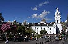
 Church of La Compañía de Jesús.
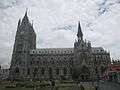
 Interior of the church of San Francisco.
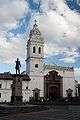 View of the Church of Santo Domingo.
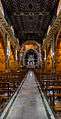 Interior of the church of Santo Domingo.
 Municipal Palace in the Plaza Grande.
 Plaza Grande.
 Centro de Arte Contemporáneo, Quito
_pic_a05.JPG) Antiguo Hospital Militar (Centro Histórico, Quito)
Antiguo Hospital Militar (Centro Histórico, Quito)
Palacio Gangotena, Quito (roof deck)
_pic._b4.JPG)
_pic._a3.JPG)
_pic._bb1.JPG)
_Centro_Hist%C3%B3rico_de_Quito_(Palacio_Gangotena%2C_Quito).JPG)
_pic._a7.JPG)
El Panecillo
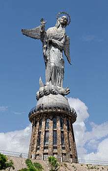


El Panecillo is a hill located in the middle west of the city at an altitude of about 3,016 metres (9,895 ft) above sea level. A monument to the Virgin Mary is located on top of El Panecillo and is visible from most of the city of Quito. In 1976, the Spanish artist Agustín de la Herrán Matorras was commissioned by the religious order of the Oblates to build a 41 metres (135 ft)–tall aluminum monument of a madonna, which was assembled on a high pedestal on the top of Panecillo. The statue of the Virgin on the Panecillo is a replica of a sculpture made by Bernardo de Legarda in 1732. So this monument is also called Virgen de Legarda or Virgen del Panecillo.
La Mariscal
This area is considered the city's entertainment center. It is the meeting point of local people and tourists. Its cosmopolitan atmosphere is expressed through the variety of gastronomy, artistic, cultural options and the large number of hotels and inns, travel agencies, language and dance schools, stores, bars, and discothèques that light up when the sun hides.[37]
Plaza Foch (La Zona)
This area is considered the zona rosa of the city. It is constituted of various night clubs and bars and has a great night vibe. Plaza Foch is most populated Thursday-Saturday, and gets tourists from all over the world. For this reason, prices for liquor and beer are expensive compared to other places in Quito.
Parks
Metropolitano
Parque Metropolitano Guanguiltagua[38] is the largest urban park in South America at 1,376 acres (5.57 km2) (as reference, New York's Central Park is 843 acres (341 ha)). The park is located in northern Quito, on the hill of Bellavista behind Estadio Olímpico Atahualpa. The park is suited for mountain biking, walking, and running. Most of it is eucalyptus forest with trails, but there also are numerous sculptures on display. The park has four sites that can be used for picnics or barbecues, and the eastern section has a view of Cotopaxi, Antisana, and the Guayllabamba river basin.
Bicentenario
Parque Bicentenario is the second largest urban park in Quito (surpassed only by the Parque Metropolitano), located in the site of the Old Mariscal Sucre International Airport. It was inaugurated on April 27, 2013. This park has 200 acres (81 ha), and it's located at 2,800 m (9,186 ft), above mean sea level. The former runway has been converted into recreational space with lanes painted for bicycles and pedestrians. There are play structures and games for children. As well, there is outdoor exercise equipment for adults. The park contains a man-made pond and more than one thousand trees, many newly planted. The park also hosts cultural exhibits and outdoor concerts.
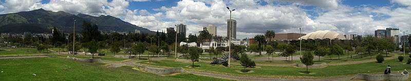
La Carolina
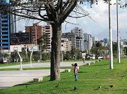
La Carolina[39] is a 165.5-acre (670,000 m²) park in the centre of the Quito main business area, bordered by the avenues Río Amazonas, de los Shyris, Naciones Unidas, Eloy Alfaro, and de la República. This park started from the expropriation of the farm La Carolina in 1939. The design of the park was made by the Dirección Metropolitana de Planificación Territorial (DMPT). Pope John Paul II headed a great mass in the park during his visit to Ecuador in 1985. A giant cross has been built in this place.
El Ejido
El Ejido[40] is the fourth-largest park of Quito (after Metropolitan, Bicentenario and La Carolina), and it divides the old part of the city from the modern one. This park is known for handicrafts available for sale every Saturday and Sunday, with all pricing subject to negotiation (that is, haggling). Local painters sell copies of paintings by Oswaldo Guayasamín,[41] Eduardo Kingman, and Gonzalo Endara Crow. Otavaleños sell traditional sweaters, ponchos, carpets, and jewelry.
Guápulo
_Calle_pic._b.JPG)
Set on the side on a cliff with González Suárez Street, one of the most famous in Quito and to the other side the valley and further in the distance, the Amazon Jungle. Guápulo is a district of Quito, Ecuador, also called an electoral parish (parroquia electoral urbana). The parish was established as a result of the October 2004 political elections when the city was divided into 19 urban electoral parishes.[42] Set behind Hotel Quito, the neighborhood of Guápulo runs down the winding Camino de Orellana, from González Suárez to Calle de los Conquistadores, the main road out of Quito and to the neighboring suburbs.[43] [44] Often considered an artsy, bohemian neighborhood of Quito, Guápulo is home to many local artists and a couple of hippy cafés/bars. Every year on September 7 the guapuleños honor their neighborhood with the Fiestas de Guápulo, a fantastic celebration complete with costumes, parade, food, drink, song, dance, and fireworks.
La Alameda
The long triangular La Alameda is located at the beginning of street Guayaquil, where the historic centre begins. It has an impressive monument of Simón Bolívar at the apex. There are several other interesting monuments in this park. In the centre of the park is the Quito Observatory, which was opened by President García Moreno in 1873 and is the oldest observatory in Latin America. It is used for both meteorology and astronomy. At the north end of the park are two ornamental lakes, where rowboats can be rented.
TeleferiQo

The Aerial tramway Station at Cruz Loma (part of the Pichincha mountain complex at about 4,000 metres (13,000 ft)). Since July 2005, Quito has had an aerial tramway, known as the "Telefériqo", from the city centre to the hill known as Cruz Loma on the east side of the Pichincha volcano. The ride takes visitors to an elevation of about 4,100 metres (13,500 ft). There are also trails for hiking and areas where pictures can be taken of Quito. Because of the increased elevation and the wind on the mountain, it is considerably cooler.
Besides the aerial tramway to Cruz Loma, the Telefériqo as a whole is a visitor centre that includes an amusement park (Vulqano Park), fine-dining restaurants, Go Karts, Paint Ball, shopping malls, an extensive food court, and other attractions.
Outside the city

La Mitad del Mundo[45] (the middle of the world) is a small village administered by the prefecture of the province of Pichincha, 35 kilometres (22 mi) north of Quito. It has since been determined, with the use of Global Positioning System technology, that the actual equator is some 240 metres (790 ft) north of the monument area.
Pululahua Geobotanical Reserve, located a few miles northwest from La Mitad del Mundo, contains the Pululahua volcano, whose caldera (crater) is visible from a spot easily accessible by car. It is believed to be one of only a few in the world with human inhabitants.
Quito Zoo,[46] located near the rural parish of Guayllabamba, about 20 kilometres (12 mi) outside Quito, has the biggest collection of native fauna in Ecuador, including several kinds of animals that are sometimes targeted in Ecuador in the illegal fur trade. The Zoo works in conservation and education in Ecuador and has successfully bred the endangered Andean condor.
Maquipucuna Reserve is located in Quito's rural parish of Nanegal. This 14,000 acre high biodiversity rainforest/cloudforest reserve protects over 1966 species of plants[47] (10% of Ecuador's plant diversity) and close to 400 bird species. This reserve, which is surrounded by a 34,000 acre protected forest, was declared an IBA (Important Bird Area) in 2005[48] and is the core of the conservation corridor for the Spectacled bear (Andean bear)declared in 2013.[49] The area has an ecolodge located in the northern end of the Reserve where the Spectacled bear can be sighted for about two months every year.
Some of the other nearby natural attractions are:
- Maquipucuna Reserve Conservation, community projects, bird watching, spectacled bear watching
- Bellavista Cloud Forest Reserve conservation and bird watching lodge
- Cayambe – Coca Ecological Reserve
- Papallacta & Oyacachi thermal springs
- Cotopaxi National Park
- Mindo Nambillo cloud forest
- Illiniza volcano
- Pasochoa Wildlife Refuge
- Pichincha volcano with its peaks Wawa Pichincha and Ruku Pichincha
Culture
Quito is a city with a mix of modern-day and traditional culture. There is a big presence of Catholics in Quito, most notably, Easter Week is a significant celebration in all Latin American countries, but Quito observes this tradition with a series of ceremonies and rituals that begin on Palm Sunday. At noon on Good Friday, the March of the Penitents proceeds from the Church of San Francisco, in memory of the hour that Pontius Pilate sentenced Jesus to be crucified.[50]
Education
Universities
According to the National Council for Higher Education of Ecuador (CONESUP), these are the universities founded in or around Quito before 2006:[51]

| University | Foundation Date |
|---|---|
| Universidad Central del Ecuador | 18/03/1826 |
| Escuela Politécnica Nacional | 27/08/1869 |
| Pontificia Universidad Católica del Ecuador | 04/11/1946 |
| de Altos Estudios Nacionales | 20/06/1972 |
| Facultad Latinoamericana de Ciencias Sociales | 16/12/1974 |
| Escuela Superior Politecnica del Ejercito E.S.P.E. | 08/12/1977 |
| Universidad Tecnológica Equinoccial | 18/02/1986 |
| Universidad Andina Simon Bolivar | 27/01/1992 |
| Internacional SEK | 30/06/1993 |
| Universidad San Francisco de Quito | 25/10/1988 |
| Universidad de las Américas (Ecuador) | 29/11/1995 |
| Universidad Internacional del Ecuador | 30/08/1996 |
| Universidad Del Pacifico: Escuela de Negocios | 18/12/1997 |
| Universidad de Especialidade Turisticas | 31/03/2000 |
| Universidad de los Hemisferios | 20/05/2004 |
| Universidad Politécnica Salesiana | 05/08/1994 |
Libraries
One of the oldest and most important library in Ecuador is the Central University Library in Quito. It was founded in 1586 and has 170,000 volumes in its possession.[52]
Museums
- Museo de Arte Contemporaneas – Located north of Basilica del Voto Nacional, this museum has permanent and temporary exhibitions. The historic building used to be a big military hospital and was renewed for its new purpose.
- Casa del Alabado Located just south of Plaza San Francisco, this is the Old Town's newest museum and houses a collection of pre-colonial art. The building is one of the oldest houses in the city.
- Museo de la Ciudad – A museum dedicated to the history of Quito. Located just east of the Plaza de Santo Domingo.[53] It is housed in the buildings of the former San Juan de Dios Hospital, a UNESCO Cultural World Heritage Site.
- La Capilla del Hombre – A museum showcasing the work of legendary Ecuadorian Artist Oswaldo Guayasamín
- Ecuador National Museum of Medicine – A museum dedicated to the history of medicine[54] in Quito, founded by Dr.Eduardo Estrella Aguirre. Dr. Estrella was in the Archives of the Royal Botanical Gardens in Madrid, Spain in 1985 and uncovered the lost papers and paintings documenting one of the first expeditions to South America. In Madrid Spain, Dr. Estrella worked for many years and documented his observations in the archive and was able to publish the hard work of Juan Tafalla in a book called Flora Huayaquilensis.
- Museo Casa de Sucre – This museum is dedicated to life of Mariscal Antonio José de Sucre, a hero of Ecuadorian independence. The ground floor has an array of weapons and military relics, many of which belonged to Sucre himself. The second floor has been restored to what it might have looked like in Sucre's time.[55]
- Museo Nacional del Banco Central del Ecuador – This art museum houses 5 displays. Each one covers a different time period, ranging from prehistory to modern Ecuador.[56]
Sports
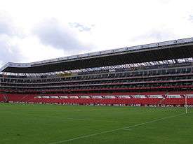
Quito is home to seven prominent football clubs in the country. The city's top clubs (LDU Quito, El Nacional) have won a total of 28 national championships, over half of all championships played. Deportivo Quito and Aucas were the first home teams to play in the national league. Deportivo Quito was also the first out of the three home teams to win the title. LDU Quito is the only Ecuadorian club to have won 4 continental titles. El Nacional is the second most titled team in Ecuador's history. América de Quito was one of the most titled clubs in the past but has recently played in the lower divisions.
The professional teams in the city are:
One of the more interesting facts of Quito is that the stadiums are located over 2,800 metres (9,200 feet) above sea level, this gives the city the special feature and a great advantage for local teams when they play against foreign teams and it is one of the reason that has allowed Ecuador to participate in the two lasts World Cups.[57]
Crime
The U.S. Department of State notes that petty theft is the most common crime issue facing tourists in Quito,[58] stating in 2015: "Pickpocketing, purse snatching, robbery, bag slashing, and hotel room theft are the most common types of crimes committed against U.S. citizens."[59]
Notable people born in Quito
- Poet Jorge Carrera Andrade (b. 1902, Quito – d. 1978, Quito)
- Novelist Jorge Icaza (b. 1906, Quito – d. 1978, Quito)
- Film Director Sebastián Cordero (b. 1972, Quito)
- Painter Oswaldo Guayasamín (b. 1919, Quito – d. 1999, Baltimore U.S.)
- Professional Footballer Christian Benitez (b. May 1, 1986, Quito – d. July 29, 2013, Doha, Qatar)
- Catholic Saint Mariana de Jesús de Paredes (b.1618,Quito – d. 1645, Quito)
- Scientist Eugenio Espejo (b. February 21, 1747 – d. December, 1795)
Twin towns and sister cities
Quito is twinned with:
 Madrid, Spain[60]
 Buenos Aires, Argentina
 Bogotá, Colombia
 Managua, Nicaragua
 Louisville, Kentucky, United States[61]
 Mexico City, Mexico[62]
 Old Quebec, Quebec, Canada
- Coral Gables, Florida, United States[61]
 La Paz, Bolivia
 Kraków, Poland[63]
- Toronto, Ontario, Canada[64]
 Surabaya, Indonesia,(since 2011)
See also
References
- 1 2 "Contact Us." TAME. Retrieved on March 14, 2010.
- 1 2 "." Petroecuador. Retrieved on February 4, 2016.
- ↑ "Security Watch: South American unity". International Relations and Security Network. Retrieved August 1, 2008.
- 1 2 3 "City of Quito – UNESCO World Heritage". Whc.unesco.org. Retrieved 2010-04-30.
- ↑ "How to Get to the Equatorial Monument (La Mitad Del Mundo)". USA Today. Retrieved 29 January 2015.
- ↑ "City" (in Spanish). Quito Distrito Metropolitano. Archived from the original (– Scholar search) on April 8, 2008. Retrieved August 2, 2008.
- ↑ Brown, Robert J. (2004). Manipulating the Ether. McFarland. pp. 251–252. ISBN 0-7864-2066-9.
- ↑ "Quito Ecuador Travel Guide - Altitude, Hotels, Airport, Tours". ecuadorexplorer.com. Retrieved 22 November 2016.
- ↑ Chris Beall. "Ecuador's top 10 volcanic experiences – travel tips and articles". Lonely Planet. Retrieved 2013-03-12.
- ↑ Naumova, En; Yepes, H; Griffiths, Jk; Sempértegui, F; Khurana, G; Jagai, Js; Játiva, E; Estrella, B (July 2007). "Guagua Pichincha". Environmental health : a global access science source. National Environmental Satellite, Data, and Information Service. 6 (1): 21. doi:10.1186/1476-069X-6-21. PMC 1947976
 . PMID 17650330. Retrieved August 2, 2008.
 - ↑ "Guagua Pichincha". Operational Significant Event Imagery. National Oceanic and Atmospheric Administration. Retrieved 2013-03-28.
- ↑ Le Pennec, J-L.; et al. (2006), "Characteristics and impacts of recent ash falls produced by Tungurahua and El Reventador volcanoes, Ecuador", Fourth Conference, Cities on Volcanoes (PDF)
- ↑ "Geography". Retrieved March 29, 2013.
- ↑ Peel, M. C. and Finlayson, B. L. and McMahon, T. A. (2007). "Updated world map of the Köppen–Geiger climate classification" (PDF). Hydrol. Earth Syst. Sci. 11: 1633–1644. doi:10.5194/hess-11-1633-2007. ISSN 1027-5606.
- ↑ "Climate: Quito – Climate graph, Temperature graph, Climate table". Climate-Data.org. Retrieved 8 October 2013.
- ↑ "Weather". Sitio Oficial Turístico de Quito. Retrieved August 2, 2008.
- ↑ "Average weather for Quito". The Weather Channel. Retrieved August 2, 2008.
- ↑ "Radiación UV nociva en Guayaquil y Quito". www.eluniverso.com. El gran Guayaquil. Retrieved 29 September 2014.
- ↑ "Alertan sobre rayos UV en Quito". www.metroecuador.com. Metro Ecuador. Retrieved 29 September 2014.
- ↑ "Yanahuaico Weather – Personal Weather Station: IPICHINC3 by Wunderground.com – Weather Underground". wunderground.com.
- ↑ "World Weather Information Service – Guayaquil". Met Office. Retrieved 16 January 2016.
- ↑ "WMO Normals – Guayaquil". NOAA. Retrieved 16 January 2016.
- ↑ "Quito Mariscal Sucre". World Weather Records 9th Series 1991–2000. National Oceanic and Atmospheric Administration. Retrieved 2 March 2013.
- ↑ "World Weather Information Service – Quito". World Meteorological Organization. Retrieved 2 March 2013.
- ↑ "Quito Monthly Temperature weather history". Voodoo Skies. Retrieved 21 November 2014.
- ↑ "Working in Quito". internations.org. Retrieved 22 November 2016.
- ↑ "GaWC – The World According to GaWC". www.lboro.ac.uk. Retrieved 2016-02-05.
- ↑ "Diccionario. Cabildo (Parroquias)". quito.gob.ec. Retrieved July 8, 2009.
- ↑ "Parroquias de Quito". Arquidiocesisdequito.org. Retrieved July 8, 2009.
- ↑ "Sistema Convencional de Transporte" (PDF) (in Spanish). Metrobús Quito. Archived from the original (PDF) on September 10, 2008. Retrieved August 4, 2008.
- ↑ "BiciQ Bicicleta Pública" (in Spanish). BiciQ. Retrieved September 13, 2013.
- ↑ "Bici Q: 1.078 carnetizados". La Hora – Nacional (in Spanish). Quito, Ecuador: La Hora. August 31, 2012. Retrieved September 13, 2013.
- ↑ "La bici pública rodará desde el martes". El Comercio.com (in Spanish). Quito: Grupo El Comercio. July 27, 2012. Retrieved September 13, 2013.
- ↑ "Cars are besieging Quito" (in Spanish). El Comercio. Archived from the original on September 27, 2007. Retrieved August 4, 2008.
- ↑ "TRAQ – Tren Rápido de Quito" (PDF) (in Spanish). Archived from the original (PDF) on February 28, 2007.
- ↑ "World bank backs Metro Quito construction". GlobalRailNews. 4 Aug 2013.
- ↑ The Great Guide Quito
- ↑ "Parque Metropolitano Guanguiltagua".
- ↑ "Sitio Oficial Turístico de Quito – Parque La Carolina". Quito.com.ec. Retrieved July 8, 2009.
- ↑ "Sitio Oficial Turístico de Quito – Parque El Ejido". Quito.com.ec. Retrieved July 8, 2009.
- ↑ Guayasamin.com Archived March 8, 2005, at the Wayback Machine.
- ↑ Planet, Lonely. "Quito – Lonely Planet". lonelyplanet.com.
- ↑ Reserved., Copyright (c) 2006–2011 METAMORF S.A. All Rights. "Guápulo, Guápulo Local Guide: Top rated Activities, Trips and Travel Tips for Guápulo, V!VA Travel Guides". vivatravelguides.com.
- ↑ Arts and Crafts in Guapulo Archived January 28, 2010, at the Wayback Machine.
- ↑ Mitaddelmundo.com Archived December 4, 2004, at the Wayback Machine.
- ↑ "Quito Zoo". Quito Zoo. Retrieved 2012-05-21.
- ↑ "Maquipucuna Florula". ucdavis.edu.
- ↑ "BirdLife Data Zone". birdlife.org.
- ↑ Conservation Corridor Resolution
- ↑ "Ecuador's Cultural Events & Festivals - Your Escape to Ecuador". yourescapetoecuador.com. Retrieved 22 November 2016.
- ↑ "Consejo Nacional de Educación Superior del Ecuador". Conesup.net. Retrieved April 30, 2010.
- ↑ "Libraries and museums - Ecuador". nationsencyclopedia.com. Retrieved 22 November 2016.
- ↑ "Museo de la Ciudad :: Quito Ecuador" (in Spanish). Museociudadquito.gov.ec. Retrieved April 30, 2010.
- ↑ "Ecuador Terra Incognita – La Flora Huayaquilensis". Terraecuador.net. 2004-02-14. Retrieved 2011-09-15.
- ↑ "Quito Official Travel Information Site – Ecuador – Sucre House-Museum". Quito.com.ec. Retrieved April 30, 2010.
- ↑ "Banco Central del Ecuador". Bce.fin.ec. Retrieved April 30, 2010.
- ↑ "Quito Sports". studylanguages.org. Retrieved 22 November 2016.
- ↑ David Thyberg USA Today Is It Safe for Americans to Travel to Quito Ecuador?
- ↑ https://www.osac.gov/pages/ContentReportDetails.aspx?cid=17759
- ↑ "Mapa Mundi de las ciudades hermanadas". Ayuntamiento de Madrid.
- 1 2 "Sister City International Listings – Directory". Sister-cities.org. Archived from the original on 2007-07-08. Retrieved 2012-05-21.
- ↑ "Convenio de amistad entre Ciudad de México y Quito" (PDF) (in Spanish). SEGOB.
- ↑ "Kraków otwarty na świat". www.krakow.pl. Retrieved July 19, 2009.
- ↑ "Toronto News: Cities cherish their friends with benefits". thestar.com. 2012-04-29. Retrieved 2012-05-21.
External links
| Wikimedia Commons has media related to Quito. |
| Wikivoyage has a travel guide for Quito. |
 "Quito". Encyclopædia Britannica. 22 (11th ed.). 1911.
- Humanitarian Missions in Quito
- Official Web site of the municipality of Quito
- Official tourism Web site of the municipality of Quito
- Wikivoyage: Quito
Provincial capitals in Ecuador | ||
|---|---|---|
Within regions, north to south | ||
| Insular |  | |
| Costa | ||
| Sierra | ||
| Oriente | ||