Historical United States Census totals for Knox County, Maine
This article shows U.S. Census totals for Knox County, Maine, broken down by municipality, from 1900 to 2000.
There are two types of incorporated municipalities in Maine, towns and cities. The tables below differentiate between towns and cities.
Most areas of New England are entirely divided into incorporated municipalities, with no unincorporated territory. In the three northern New England states, however, some unincorporated territory does exist, generally in areas that are very sparsely populated. Maine contains significantly more unincorporated territory than the other states, with the bulk of it in interior and northern counties. Some southern and coastal counties, including Knox County, also contain smaller amounts of unincorporated territory, however.
Some unincorporated territory in Maine is organized into a third type of town-level municipality unique to Maine, called a plantation (considered to be “organized”, but not incorporated), while some is entirely unorganized. Knox County currently contains one plantation (Matinicus Isle), as well as a small amount of territory that is entirely unorganized (the former Criehaven Plantation). All of Knox County’s unincorporated area is on offshore islands. Separate sections with census totals for unincorporated areas follow the main tables below. For any census, adding up the totals for each town-level municipality, including any plantations or unorganized entities, should yield the county total. Except for Matinicus and Criehaven, all of Knox County is incorporated; except for Criehaven, all of the county is at least organized. (For a period in the late 19th and early 20th centuries, Knox County was entirely organized, but it has never been entirely incorporated.)
For more information on the New England municipal system, see New England town.
Corporate changes since 1900
- 1913 – Isle Au Haut, formerly part of Hancock County, joined Knox County
- 1915 – Hurricane Isle disincorporated and reverted to unorganized territory (its former territory was later annexed to a nearby town)
- 1921 – New town of Owls Head formed from South Thomaston
1900
County Total: 30,406
- Rockland (city) 8,150
- Camden 2,825
- Thomaston 2,688
- Vinalhaven 2,358
- Rockport 2,314
- St. George 2,206
- Warren 2,069
- South Thomaston 1,426
- Union 1,248
- Washington 1,019
- Appleton 975
- Friendship 814
- Cushing 604
- Hope 599
- North Haven 551
- Hurricane Isle 257
Unincorporated territory reported 303 residents, all in organized plantations.
1910
County Total: 28,981
- Rockland (city) 8,174
- Camden 3,015
- Vinalhaven 2,334
- Thomaston 2,205
- St. George 2,201
- Rockport 2,022
- Warren 1,812
- South Thomaston 1,438
- Union 1,233
- Appleton 842
- Washington 814
- Friendship 776
- Cushing 535
- North Haven 535
- Hope 497
- Hurricane Isle 256
Unincorporated territory reported 292 residents, all in organized plantations.
1920
County Total: 26,245
- Rockland (city) 8,109
- Camden 3,403
- Thomaston 2,019
- Vinalhaven 1,965
- Rockport 1,774
- St. George 1,654
- Warren 1,500
- Union 1,133
- South Thomaston 947
- Friendship 696
- Appleton 683
- Washington 660
- North Haven 510
- Hope 424
- Cushing 416
- Isle Au Haut 102
Unincorporated territory reported 214 residents. This consisted of 203 residents in organized plantations, and 47 residents in unorganized territory.
1930
County Total: 27,693
- Rockland (city) 9,075
- Camden 3,606
- Thomaston 2,214
- St. George 2,108
- Vinalhaven 1,843
- Rockport 1,651
- Warren 1,429
- Union 1,060
- Friendship 742
- Washington 615
- South Thomaston 579
- Appleton 574
- Owls Head 574
- North Haven 476
- Hope 464
- Cushing 350
- Isle Au Haut 89
Unincorporated territory reported 244 residents. This consisted of 156 residents in an organized plantation, and 88 residents in unorganized territory.
1940
County Total: 27,191
- Rockland (city) 8,899
- Camden 3,554
- Thomaston 2,533
- Vinalhaven 1,629
- St. George 1,550
- Rockport 1,526
- Warren 1,458
- Union 1,150
- Friendship 747
- Washington 689
- Appleton 641
- Owls Head 609
- South Thomaston 538
- Hope 524
- North Haven 460
- Cushing 362
- Isle Au Haut 97
Unincorporated territory reported 225 residents. This consisted of 112 residents in an organized plantation, and 113 residents in unorganized territory.
1950
County Total: 28,121
- Rockland (city) 9,234
- Camden 3,670
- Thomaston 2,810
- Rockport 1,656
- Warren 1,576
- St. George 1,482
- Vinalhaven 1,427
- Union 1,085
- Owls Head 784
- Friendship 772
- Washington 722
- Appleton 671
- South Thomaston 654
- Hope 504
- North Haven 410
- Cushing 376
- Isle Au Haut 82
Unincorporated territory reported 206 residents. This consisted of 188 residents in an organized plantation, and 18 residents in unorganized territory.
1960
County Total: 28,575
- Rockland (city) 8,769
- Camden 3,988
- Thomaston 2,780
- Rockport 1,893
- Warren 1,678
- St. George 1,588
- Vinalhaven 1,273
- Union 1,196
- Owls Head 994
- Friendship 806
- South Thomaston 732
- Appleton 672
- Washington 636
- Hope 525
- Cushing 479
- North Haven 384
- Isle Au Haut 68
Unincorporated territory reported 114 residents. This consisted of 100 residents in an organized plantation, and 14 residents in unorganized territory.
1970
County Total: 29,013
- Rockland (city) 8,505
- Camden 4,115
- Thomaston 2,646
- Rockport 2,067
- Warren 1,864
- St. George 1,639
- Owls Head 1,281
- Union 1,189
- Vinalhaven 1,135
- Friendship 834
- South Thomaston 831
- Washington 723
- Appleton 628
- Cushing 522
- Hope 500
- North Haven 399
- Isle Au Haut 45
Unincorporated territory reported 90 residents, all in Matinicus Isle Plantation; unorganized territory reported no population.
1980
County Total: 32,941
- Rockland (city) 7,919
- Camden 4,584
- Thomaston 2,900
- Rockport 2,749
- Warren 2,566
- St. George 1,948
- Owls Head 1,633
- Union 1,569
- Vinalhaven 1,211
- South Thomaston 1,064
- Friendship 1,000
- Washington 954
- Appleton 818
- Cushing 795
- Hope 730
- North Haven 373
- Isle Au Haut 57
Unincorporated territory reported 71 residents. This consisted of 66 residents in an organized plantation, and 5 residents in unorganized territory.
1990
County Total: 36,310
- Rockland (city) 7,972
- Camden 5,060
- Thomaston 3,306
- Warren 3,192
- Rockport 2,854
- St. George 2,261
- Union 1,989
- Owls Head 1,574
- South Thomaston 1,227
- Washington 1,185
- Friendship 1,099
- Vinalhaven 1,072
- Appleton 1,069
- Hope 1,017
- Cushing 988
- North Haven 332
- Isle Au Haut 46
Unincorporated territory reported 67 residents, all in Matinicus Isle Plantation; unorganized territory reported no population.
2000
County Total: 39,618
- Rockland (city) 7,609
- Camden 5,254
- Warren 3,794
- Thomaston 3,748
- Rockport 3,209
- St. George 2,580
- Union 2,209
- Owls Head 1,601
- South Thomaston 1,416
- Washington 1,345
- Cushing 1,322
- Hope 1,310
- Appleton 1,271
- Vinalhaven 1,235
- Friendship 1,204
- North Haven 381
- Isle Au Haut 79
Unincorporated territory reported 51 residents, all in Matinicus Isle Plantation; unorganized territory reported no population.
Plantations
As of 1900, Knox County contained three plantations: Criehaven, Matinicus Isle and Muscle Ridge. All were located on offshore islands (the mainland of the county was then, and is now, entirely divided into incorporated towns).
Matinicus Isle is the only plantation that remains today. Muscle Ridge and Criehaven surrendered their organization in 1916 and 1925, respectively. When they did so, both reverted to unorganized territory, but Muscle Ridge's former territory was later annexed to a nearby town. Criehaven's former territory remains unorganized.
1900
- Matinicus Isle 184
- Muscle Ridge 72
- Criehaven 47
1910
- Matinicus Isle 179
- Muscle Ridge 67
- Criehaven 46
1920
- Matinicus Isle 140
- Criehaven 63
1930
- Matinicus Isle 156
1940
- Matinicus Isle 112
1950
- Matinicus Isle 188
1960
- Matinicus Isle 100
1970
- Matinicus Isle 90
1980
- Matinicus Isle 66
1990
- Matinicus Isle 67
2000
- Matinicus Isle 51
Unorganized Territory
As of 1900, Knox County was entirely organized. The dissolutions of the town of Hurricane Isle (1915), Muscle Ridge Plantation (1916) and Criehaven Plantation (1925) all created unorganized territory, however, as each reverted to that state. The former territories of Hurricane Isle and Muscle Ridge were later annexed to nearby towns, leaving only Criehaven as unorganized territory today (see the Notes section for more information).
The former Criehaven Plantation consists of a small group of islands, covering less than one square mile of land, adjacent to (and once part of, before organizing separately) Matinicus Isle Plantation. This area is sometimes referred to as “Criehaven Township”. Its population has not exceeded 20 in any census since 1940, and in recent censuses it has reported few if any year-round residents.
1900 through 1920
There was no unorganized territory in Knox County at the time of these censuses.
1920
Unorganized territory reported 47 residents. The unorganized territory consisted of the former Muscle Ridge plantation (pop. 36) and the former town of Hurricane Isle (pop. 11).
1930
Unorganized territory reported 88 residents. No breakdown was provided, but it would seem to have included some combination of territory that had been part of the former town of Hurricane Isle and/or the former Criehaven and Muscle Ridge plantations.
1940
Unorganized territory reported 113 residents. No breakdown was provided, but it would seem to have included some combination of territory that had been part of the former town Criehaven and/or Muscle Ridge plantation.
1950
Unorganized territory reported 18 residents. No breakdown was provided, but it would seem to have included the former Criehaven plantation.
1960
Unorganized territory reported 14 residents, all in the former Criehaven Plantation, which was the only unorganized territory in the county.
1970
Unorganized territory reported no residents. The only unorganized territory in the county was the former Criehaven Plantation.
1980
Unorganized territory reported 5 residents, all in the former Criehaven Plantation, which was the only unorganized territory in the county.
1990
Unorganized territory reported no residents. The only unorganized territory in the county was the former Criehaven Plantation.
2000
Unorganized territory reported no residents. The only unorganized territory in the county was the former Criehaven Plantation.
Notes
Unorganized territory in 1930 through 1950 Censuses
During the 1910s and 1920s, three municipalities in Knox County, all located on offshore islands, dissolved: the town of Hurricane Island, Muscle Ridge Plantation, and Criehaven Plantation. While Criehaven apparently reverted to unorganized territory and has continued to hold that status down to the present time, sources contain conflicting information as to the disposition of Hurricane Isle and Muscle Ridge after their dissolution. It is apparent that the former territory of Hurricane Isle and Muscle Ridge was eventually annexed to other municipalities (unlike Criehaven, they no longer exist today as distinct entities in any form), but at least some of their territory may have continued for a time after their dissolution as unorganized territory.
The 1920 Census provided distinct listings for Hurricane Isle and Muscle Ridge as unorganized townships (as well as a listing for Criehaven, which was still an organized plantation at the time). The 1930 through 1950 Censuses handle unorganized territory via a single listing for “Islands not belonging to any town”, however, with no indication of exactly what this is. The population figures for 1930 and 1940 are significantly higher than any figure for Criehaven before or since, which suggests that, at least for those two censuses, the area covered may be larger than Criehaven.
For the 1960 Census, the Census Bureau abandoned any attempt to provide breakdowns for unorganized territory within Maine counties, simply providing a single listing for “Unorganized Territory”. Starting in 1970, the Census Bureau began using defined “unorganized territories”. In each census since then, the unorganized territory in Knox County has been shown as “Criehaven”. A footnote in the 1970 Census reports also indicates that the territory shown as “Criehaven” in that census is the same as the territory shown as “Unorganized Territory” in the 1960 Census. From this, it seems that Criehaven has been the only remaining unorganized territory in Knox County at least as far back as the 1960 Census. Given the similarity between the 1950 population for “Islands not belonging to any town” and the 1960 population figure for “Unorganized Territory”, this may be true back to 1950 as well, but this is not known with any certainty.
See also
- Knox County, Maine topics
- United States Census
Historical U.S. census figures for Maine | ||
|---|---|---|
 | ||
Municipalities and communities of Knox County, Maine, United States | ||
|---|---|---|
| City | 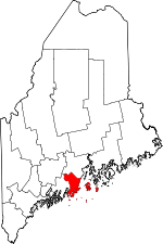 | |
| Towns | ||
| Plantation | ||
| Unorganized territory | ||
| CDPs | ||
| Other villages | ||