Hockley Brook
| Hockley Brook | |
|---|---|
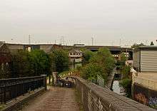 The brook (right) near its end, with the Birmingham & Fazeley canal alongside. | |
| Etymology | Aston |
| Basin | |
| River mouth | River Tame |
| Progression | Trent - Humber - North Sea |
| Features | |
| Tributaries |
|
Hockley Brook is a brook, or stream, in north Birmingham, England. It rises just outside the city, in Smethwick, and runs though Black Patch Park and then through the city's Soho, Hockley and Aston districts, to its confluence with the River Tame, beneath Gravelly Hill Interchange. From there, its waters flow, via the Trent, to the Humber Estuary and the North Sea. At the eastern end, it is known to locals as Aston Brook, giving its name to Aston Brook Street.
It previously marked the boundary between Birmingham (then Warwickshire) and Smethwick (then Staffordshire); between the then Staffordshire country villages of Handsworth and Smethwick;[1] and between Birmingham and Aston, before the city absorbed the latter district.
The brook once fed several mills[2] and provided water for Matthew Boulton's Soho Manufactory.[3]
In post-World War II years, it was culverted (buried in pipes) for much of its length.
Local historian and artist Ron "Smudge" Smith titled his 1998 autobiography A Paddle in Hockley Brook.[4]
Features
| Point | Coordinates (links to map & photo sources) |
Notes |
|---|---|---|
| Source | 52°29′48″N 1°56′40″W / 52.496614°N 1.944522°W | |
| Start of main underground section | 52°29′46″N 1°55′10″W / 52.496046°N 1.919417°W | |
| End of main underground section | 52°29′59″N 1°52′21″W / 52.499775°N 1.872478°W | |
| Confluence with River Tame | 52°30′29″N 1°51′37″W / 52.508184°N 1.860258°WRiver Tame) |
References
- ↑ Ted Rudge Brumroamin: Birmingham and Midland Romany Gypsy and Traveller Culture. Birmingham City Council Department of Leisure & Community Services (2003)
- ↑ "All Saints - WAR ENG". University of Essex. Retrieved 25 October 2011.
- ↑ "Pubs of Winson Green in Birmingham". Midlands Pubs. Retrieved 25 October 2011.
- ↑ Smith, Ron (1998). A Paddle in Hockley Brook (4th ed.). Waveney Publ. ISBN 0-9523849-0-6.
External links
Coordinates: 52°29′46″N 1°55′10″W / 52.496046°N 1.919417°W