Hohenbocka
Hohenbocka (Lower Sorbian Hory Bukow, Polish Buków[2]) is a municipality in the Oberspreewald-Lausitz district, in southern Brandenburg, Germany.
Demography
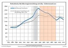
Development of Population since 1875 within the Current Boundaries (Blue Line: Population; Dotted Line: Comparison to Population Development of Brandenburg state; Grey Background: Time of Nazi rule; Red Background: Time of Communist rule)
Hohenbocka:
Population development within the current boundaries[3]
| Year |
Population |
|
|
|---|
| 1875 | 700 |
| 1890 | 700 |
| 1910 | 1 000 |
| 1925 | 1 164 |
| 1933 | 1 300 |
| 1939 | 1 538 |
| 1946 | 1 697 |
| 1950 | 1 630 |
| 1964 | 1 465 |
| 1971 | 1 435 |
|
|
| Year |
Population |
|
|
|---|
| 1981 | 1 269 |
| 1985 | 1 181 |
| 1989 | 1 134 |
| 1990 | 1 098 |
| 1991 | 1 082 |
| 1992 | 1 076 |
| 1993 | 1 092 |
| 1994 | 1 098 |
| 1995 | 1 109 |
| 1996 | 1 113 |
|
|
| Year |
Population |
|
|
|---|
| 1997 | 1 139 |
| 1998 | 1 165 |
| 1999 | 1 187 |
| 2000 | 1 210 |
| 2001 | 1 209 |
| 2002 | 1 195 |
| 2003 | 1 194 |
| 2004 | 1 191 |
| 2005 | 1 177 |
| 2006 | 1 161 |
|
|
| Year |
Population |
|
|
|---|
| 2007 | 1 146 |
| 2008 | 1 127 |
| 2009 | 1 113 |
| 2010 | 1 098 |
| 2011 | 1 041 |
| 2012 | 1 022 |
|
|
Detailed data sources are to be found in the Wikimedia Commons.[4]
References