Lauchhammer
Lauchhammer is a town in the Oberspreewald-Lausitz district, in southern Brandenburg, Germany. It is situated on the Black Elster river, approx. 17 km west of Senftenberg, and 50 km north of Dresden.
Demography
Development of Population since 1875 within the Current Boundaries (Blue Line: Population; Dotted Line: Comparison to Population Development of Brandenburg state; Grey Background: Time of Nazi rule; Red Background: Time of Communist rule)
Recent Population Development (Blue Line) and Forecasts
Lauchhammer:
Population development within the current boundaries (2013)[2]
| Year |
Population |
|---|
| 1875 | 4 627 |
| 1890 | 6 054 |
| 1910 | 10 151 |
| 1925 | 17 259 |
| 1933 | 19 734 |
| 1939 | 22 467 |
| 1946 | 28 063 |
| 1950 | 27 524 |
| 1964 | 32 757 |
| 1971 | 31 854 |
|
|
| Year |
Population |
|---|
| 1981 | 27 102 |
| 1985 | 26 626 |
| 1989 | 25 756 |
| 1990 | 24 945 |
| 1991 | 23 882 |
| 1992 | 23 911 |
| 1993 | 23 682 |
| 1994 | 23 386 |
| 1995 | 22 948 |
| 1996 | 22 551 |
|
|
| Year |
Population |
|---|
| 1997 | 22 022 |
| 1998 | 21 684 |
| 1999 | 21 353 |
| 2000 | 20 769 |
| 2001 | 20 276 |
| 2002 | 19 826 |
| 2003 | 19 407 |
| 2004 | 19 060 |
| 2005 | 18 697 |
| 2006 | 18 396 |
|
|
| Year |
Population |
|---|
| 2007 | 18 021 |
| 2008 | 17 593 |
| 2009 | 17 276 |
| 2010 | 16 956 |
| 2011 | 15 877 |
| 2012 | 15 624 |
| 2013 | 15 252 |
|
|
References


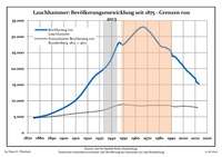 Development of Population since 1875 within the Current Boundaries (Blue Line: Population; Dotted Line: Comparison to Population Development of Brandenburg state; Grey Background: Time of Nazi rule; Red Background: Time of Communist rule)
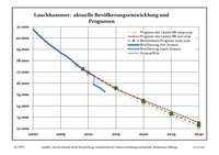 Recent Population Development (Blue Line) and Forecasts