Holme St Cuthbert
| Holme St. Cuthbert | |
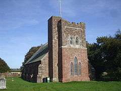 The church at Holme St. Cuthbert, constructed from local sandstone. |
|
 Holme St. Cuthbert |
|
| Population | 465 (2011)[1] |
|---|---|
| OS grid reference | NY104470 |
| Civil parish | Holme St. Cuthbert |
| District | Allerdale |
| Shire county | Cumbria |
| Region | North West |
| Country | England |
| Sovereign state | United Kingdom |
| Post town | Maryport |
| Postcode district | CA15 |
| Dialling code | 01900 |
| Police | Cumbria |
| Fire | Cumbria |
| Ambulance | North West |
| EU Parliament | North West England |
| UK Parliament | Workington |
Coordinates: 54°48′38″N 3°23′37″W / 54.8106°N 3.3935°W
Holme St. Cuthbert (occasionally Holme St. Cuthberts; pronounced and occasionally written Holme Saint Cuthbert) is a small hamlet and civil parish in the borough of Allerdale, in the county of Cumbria, United Kingdom. The hamlet is located approximately 23 miles to the south-west of Carlisle, Cumbria's county town, and was historically in the county of Cumberland.
The Civil Parish
The civil parish of Holme St. Cuthbert is a rural area, and includes the village of Mawbray and the hamlets of Aikshaw, Beckfoot, Cowgate, Dubmill, Edderside, Goodyhills, Hailforth, Jericho, New Cowper, Newtown, Pelutho, Plasketlands, Salta, and Tarns.[2] It is bordered to the north by the civil parish of Holme Low, to the east by Holme Abbey, to the south by Allonby along the Black Dub beck, and to the south-east by Westnewton. On its western side, the parish meets the Solway Firth, and has approximately four miles of coastline.
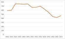
There were 421 residents in 160 households at the 2001 census,[3] and at the 2011 census, that number had risen to 465 residents in 185 households,[4] an increase of 10.5% in ten years. Despite the recent increase, however, the parish's population remains well below where it was in the 19th and early 20th centuries. In 1871-2, the population was given as 821,[5] and steadily declined in the years to at least 1961,[6] when it reached similar levels to those recorded in 2011.
Mawbray, being the largest village in the parish, is the hub of the community. Mawbray's village hall is frequently used for a wide range of activities,[11] and the Lowther Arms in Mawbray has been a popular spot for food and drink with residents of the parish since it re-opened in 2014 after two periods of closure in the 2000s and early 2010s.[12]
Before becoming a parish of its own in 1857,[13] Holme St. Cuthbert was listed as a quarter of the parish of Holme Cultram by at least 1801. The quarter was centred around Mawbray - then known as Old Malbray. Holme St. Cuthbert was also known as St. Cuthbert's township at that time.[14]
During the Second World War, 43 evacuees from Newcastle-Upon-Tyne and the surrounding area were billeted to farms in the parish.[15]
Holme St. Cuthbert parish council took a stand against plans by the British government to use west Cumbria as a disposal and storage site for nuclear waste. The process, called Managing Radioactive Waste Safely (MRWS) drew strong objections from the community at a meeting on the subject, and the council accordingly adopted a motion calling for west Cumbria to withdraw from the MRWS process. The main reasons for objecting were concerns about geology, damage to local tourism, and safety. Furthermore, the council stated that they had "no confidence" in their right to withdraw from the process as it progressed.[16]
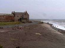
Extremes of weather are uncommon in the parish, but one serious danger is from the sea. With over four miles of coastline in the parish, and a major road (the B5300) sticking very close to the shore, storms and even very high tides are a threat. In 2014 the sea wall at Dubmill Point, near Salta, was breached in several places, and a £130,000 repair scheme was commissioned by Cumbria County Council.[17][18]
The Hamlet
Holme St. Cuthbert itself is particularly small. While it is home to the parish church,[19] church hall, and the local primary school,[20] there are very few houses.[21] There are two school buildings - the main building and a second, smaller one which serves as both the sports hall and canteen. Separating the two buildings is a car park, shared between the school and church.
St. Cuthbert's Church was constructed of locally quarried sandstone, and remains in use today. The primary school, though it caters to less than 50 pupils, has been rated as "outstanding" by school inspectors Ofsted.[22] The church and school were built in 1845.[23] The opening of the church in that year meant that the hamlet was no longer part of the parish of Holme Abbey, but instead was to become the namesake of a new parish.
The hamlet lies along the road which runs from the B5300 coast road at Mawbray to the B5301 at Tarns. There is also a junction in the hamlet, where a side roads leads past the church hall to Goodyhills, less than a quarter of a mile away, and Jericho. There are no regular public transport links, though a school bus stops in the hamlet bound for the Nelson Thomlinson school in Wigton. The nearest stop on a regular bus service is at Mawbray, where services run every two hours toward Maryport in the south and Silloth-on-Solway in the north. The nearest railway station is at Aspatria, five-and-a-half miles to the south-east, where trains on the Cumbrian Coast line run approximately once an hour north toward Carlisle and south toward Whitehaven, and occasionally Barrow-in-Furness and Lancaster.
Etymology
The name is derived from Old Norse, where the Norse word "holmr" meant "islet". Hence, "Holme St. Cuthbert" means "St. Cuthbert's islet".[24][25] Saint Cuthbert, for whom the church is named, was an early Anglo-Saxon Saint who is most famous for his association with Lindisfarne Gospels. While it is unlikely he visited the parish, he definitely visited Carlisle during his lifetime,[26] and is celebrated across the north of England and southern Scotland.
See also
References
- ↑ "Parish population 2011". Retrieved 18 June 2015.
- ↑ http://www.cumbriaobservatory.org.uk/instantatlas/CumbriaGeographyAtlas/atlas.html
- ↑ "Holme St Cuthbert (parish): Key Figures for the 2001 Census". Office for National Statistics. Retrieved 16 January 2016.
- ↑ "Neighbourhood Statistics - Lead Key Figures for Holme St. Cuthbert parish". Retrieved 15 February 2015.
- ↑ "Vision of Britain - Holme St. Cuthbert". Retrieved 18 February 2015.
- ↑ "Vision of Britain - Holme St. Cuthbert historical population". Retrieved 18 February 2015.
- ↑ Parson & White (1976) [1821]. History, directory and gazetteer of Cumberland & Westmorland with Furness and Cartmel. Michael Moon. p. 340. ISBN 0 904131 12 2.
- ↑ "Vision of Britain - Holme St. Cuthbert CP through time". Retrieved 19 August 2015.
- ↑ "Non Metropolitan District of Allerdale: Parish headcounts". Office for National Statistics. Retrieved 16 January 2016.
- ↑ "Neighbourhood Statistics - Lead Key Figures for Holme St. Cuthbert parish". Office for National Statistics. Retrieved 15 February 2015.
- ↑ https://www.facebook.com/pages/Culterham-hall-Mawbray/352423119039
- ↑ http://www.solwaybuzz.co.uk/Issues/issue_130/page_all.pdf Solway Buzz, December 2014, page 7.
- ↑ "Solway Plain Churches". Retrieved 25 July 2016.
- ↑ Parson & White (1976) [1821]. History, directory and gazetteer of Cumberland & Westmorland with Furness and Cartmel. Michael Moon. p. 341. ISBN 0 904131 12 2.
- ↑ "Holme St Cuthbert history group - The Evacuees".
- ↑ "Holme St. Cuthbert parish council letter - MRWS" (PDF).
- ↑ "BBC News - Cumbria coastal floods leave tons of debris". Retrieved 22 December 2014.
- ↑ "Cumbria County Council - Dubmill Point sea defence repairs underway". Retrieved 22 December 2014.
- ↑ http://www.visitcumbria.com/wc/holme-st-cuthbert-St-cuthberts-church/
- ↑ http://www.hstcuth.cumbria.sch.uk
- ↑ https://www.google.it/maps/@54.8106062,-3.3931406,190m/data=!3m1!1e3
- ↑ http://www.cumberlandnews.co.uk/news/kind-caring-school-outstanding-says-ofsted-1.170315
- ↑ http://www.carlislediocese.org.uk/our-churches/parishes-clergy/solway/6330.html
- ↑ Armstrong, A. M.; Mawer, A.; Stenton, F. M.; Dickens, B. (1950). The place-names of Cumberland. English Place-Name Society, vol.xxi. Part 2. Cambridge: Cambridge University Press. p. 295.
- ↑ Armstrong, A. M.; Mawer, A.; Stenton, F. M.; Dickens, B. (1952). The place-names of Cumberland. English Place-Name Society, vol.xxii. Part 3. Cambridge: Cambridge University Press. p. 478.
- ↑ http://myweb.tiscali.co.uk/hstchg/anglos.htm
External links
| Wikimedia Commons has media related to Holme St Cuthbert. |
- Cumbria County History Trust: Holme St. Cuthbert (nb: provisional research only – see Talk page)
- http://www.visitcumbria.com/wc/chw21.htm
- http://www.axcis.co.uk/schools-directory/Holme-St-Cuthbert-Primary-School/28512