Holy Trinity Church, Sunderland
elevation.jpg)
Holy Trinity is a church in Sunderland. It was opened in 1719 as the church for the newly created Parish of Sunderland.[1]
It is a listed building and is one of the oldest buildings in the East End of Sunderland.[1][2]
It is unknown who built the church, but what is known for sure is that Daniel Newcombe – who was appointed rector – and William Etty were involved in some of its design.[3][4] A plaque marking its Grade I listed building status credits Etty as the designer.[5] In its early years, the building was also home to the Select Vestrymen — in effect the town council — and the library[5] and the mechanical fire pump.
The church is no longer used for regular worship. This grade 1 listed building is in the care of the Churches Conservation Trust,[6] and is being restored with support from The Heritage Lottery Fund and other funders.
History
- 1712 — Local merchants campaign for a new church to be built.
- 1719 — First recorded baptisms, of Primus Barwick and Mary Whiton, on July 25.
- 1719 — Church consecrated on September 5.
- 1735 — Near-circular apse with Venetian window added by Daniel Newcombe, as the church initially had no chancel.[7]
- 1803 — Gallery added.Roof reconstructed by Thomas Wilson and windows re-glazed.
- 1838 — Memorial erected to Revd Robert Gray, rector from 1819 to 1838.
- 1856 — Clockface on tower added.[8]
- 1842 — Gallery extension constructed, but later removed.
- 1900 (circa) — Windows re-glazed for the second time.
- 1936 — Organ built.
- 1939–1945 — slight war damage.
- 1980s — building in need of expensive repairs.
- 1988 — cost of renovation and dwindling congregation cause the final service to be held on June 26, and church the closes a few days later.
Gallery
.jpg) Jack Crawford memorial in the graveyard
Jack Crawford memorial in the graveyardelevation.jpg) Southern (side) elevation
Southern (side) elevation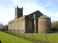 View of apse with tower in background
See also
| Wikimedia Commons has media related to Holy Trinity, Sunderland. |
- Grade I listed buildings in Tyne and Wear
- List of churches preserved by the Churches Conservation Trust in Northern England
References
- 1 2 BBC Wear Online. "Holy Trinity Church - photo gallery (image 1)". Retrieved 2007-04-07.
- ↑ Wearside Online. "Holy Trinity Church". Retrieved 2007-04-07.
- ↑ "tomorrows-history.com - Church of the Holy Trinity". Archived from the original on 2007-09-11. Retrieved 2007-04-07.
- ↑ Sunderland Public Library Service. "Local Studies Centre Factsheet No. 3 - Old Sunderland Parish Church" (PDF). Archived from the original (PDF) on 2007-09-27. Retrieved 2007-04-07.
- 1 2 BBC Wear Online. "Holy Trinity Church - photo gallery (image 4)". Retrieved 2007-04-07.
- ↑ Holy Trinity Church, Sunderland, Tyne & Wear, Churches Conservation Trust, retrieved 18 October 2016
- ↑ Church Gazetteer. "Sunderland, Holy Trinity". Archived from the original on 2004-03-28. Retrieved 2004-04-07.
- ↑ BBC Wear Online. "Holy Trinity Church - photo gallery (image 3)". Retrieved 2007-04-07.
Coordinates: 54°54′28″N 1°22′08″W / 54.907714°N 1.369006°W