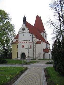
Horní Stropnice
| Horní Stropnice | |||
|---|---|---|---|
| Municipality | |||
 | |||
| |||
 Horní Stropnice | |||
| Coordinates: 48°45′41″N 14°44′11″E / 48.76139°N 14.73639°ECoordinates: 48°45′41″N 14°44′11″E / 48.76139°N 14.73639°E | |||
| Country |
| ||
| Region | South Bohemian | ||
| District | České Budějovice | ||
| Area | |||
| • Total | 79.95 km2 (30.87 sq mi) | ||
| Elevation | 543 m (1,781 ft) | ||
| Population (2011) | |||
| • Total | 1,551 | ||
| • Density | 19/km2 (50/sq mi) | ||
| Postal code | 373 35 | ||
| Website | http://www.horni-stropnice.cz | ||
Horní Stropnice (German Strobnitz) is a village and municipality (obec) in České Budějovice District in the South Bohemian Region of the Czech Republic.
The municipality covers an area of 79.95 square kilometres (30.87 sq mi), and has a population of 1,592 (as at 31 December 2007).
Horní Stropnice lies approximately 31 kilometres (19 mi) south-east of České Budějovice and 149 km (93 mi) south of Prague.
Notable residents
- Wenzel Jaksch (1896–1966), politician
References
| Wikimedia Commons has media related to Horní Stropnice. |
This article is issued from Wikipedia - version of the 4/7/2016. The text is available under the Creative Commons Attribution/Share Alike but additional terms may apply for the media files.