Horsemonger Lane Gaol
Horsemonger Lane Gaol (also known as the Surrey County Gaol or the New Gaol) was a prison close to present-day Newington Causeway in Southwark, south London.
History
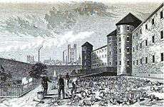
Constructed between 1791 and 1799 to a design by George Gwilt the Elder, architect surveyor to the county of Surrey, this was once the largest prison in the county, and was adjacent to Sessions House, a court building also designed by Gwilt. It was built to replace the old county gaol housed at what had been the nearby 'White Lion Inn' on Borough High Street, Southwark (informally called the 'Borough Gaol') dating from the Tudor period.
Horsemonger Lane remained Surrey’s principal prison and place of execution up to its closure in 1878. It was a common gaol, housing both debtors and criminals, with a capacity of around 300 inmates. In total, 131 men and four women were executed there between 1800 and 1877, the gallows being erected on the flat roof of the prison's gatehouse.
By 1859, the gaol was no longer known as 'Horsemonger Lane' following the road's change of name to Union Road (today: Harper Road), being renamed Surrey County Gaol (although its alternative name, the New Gaol, the gaol should not be confused with the New Prison, located north of the River Thames in Clerkenwell).
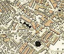
The gaol was demolished in 1881 and the site is today a public park, Newington Gardens, adjacent to the present Inner London Crown Court, opened in January 1921.
Literary connections
In 1849, Charles Dickens attended the public hangings outside the gaol of husband and wife Frederick and Maria Manning, who had killed a friend for his money and buried him under the kitchen floor. Dickens wrote to The Times condemning such public spectacles.[1]
Dickens later based the character of Hortense in Bleak House on Maria Manning, while Mrs Chivery's tobacco shop in Little Dorrit is located on Horsemonger Lane.[2] Executions at Horsemonger Lane are also mentioned in Sarah Waters' novel Fingersmith.
Inmates
- Edward Marcus Despard (executed at the gaol on 21 February 1803)
- Leigh Hunt
- Maria Manning (executed at the gaol, alongside her husband, on 13 November 1849)
- William Chester Minor
- Robert Taylor
- Arthur Tooth
- Margaret Waters (executed at the gaol on 11 October 1870)
- Thomas Cathie Wheeler. Held April 1852 following matricide committed by him. At his Old Bailey trial he was sent to Broadmoor as insane, to be detained at Her Majesty's pleasure.
See also
References
- Horsemonger Lane Gaol
- London footprints: Crime & Punishment
- 'The Old Kent Road', Old and New London: Volume 6 (1878), pp. 248-55. URL: http://www.british-history.ac.uk/report.asp?compid=45279. Date accessed: 19 December 2006.
- Old Towns of England, London in 1839, Pt 6
- Index to deaths, 1798-1878, in Surrey County Gaol
- ↑ http://www.capitalpunishmentuk.org/mannings.html Mannings murder and execution
- ↑ Dickens' London map
Coordinates: 51°29′52″N 0°05′46″W / 51.4977°N 0.0960°W