Hrušovany (Chomutov District)
| Hrušovany | |||
|---|---|---|---|
| Municipality | |||
 | |||
| |||
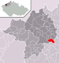 Location in Chomutov District | |||
 Hrušovany Location in the Czech Republic | |||
| Coordinates: 50°23′14″N 13°29′54″E / 50.38722°N 13.49833°ECoordinates: 50°23′14″N 13°29′54″E / 50.38722°N 13.49833°E | |||
| Country |
| ||
| Region | Ústí nad Labem | ||
| District | Chomutov | ||
| Area | |||
| • Total | 12.57 km2 (4.85 sq mi) | ||
| Elevation | 300 m (1,000 ft) | ||
| Population (2006) | |||
| • Total | 412 | ||
| • Density | 33/km2 (85/sq mi) | ||
| Postal code | 431 43 | ||
| Website | http://www.obec-hrusovany.cz | ||


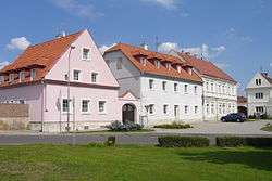
Hrušovany is a village and municipality (obec) in Chomutov District in the Ústí nad Labem Region of the Czech Republic.
The municipality covers an area of 12.57 square kilometres (4.85 sq mi), and has a population of 412 (as at 28 August 2006).
Hrušovany lies approximately 12 kilometres (7 mi) south-east of Chomutov, 49 km (30 mi) south-west of Ústí nad Labem, and 74 km (46 mi) north-west of Prague.
People
- Theodor Veidl[1]
References
This article is issued from Wikipedia - version of the 4/7/2016. The text is available under the Creative Commons Attribution/Share Alike but additional terms may apply for the media files.