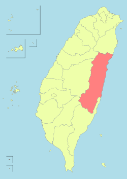
Hualien County
| Hualien County 花蓮縣 | |||
|---|---|---|---|
| County | |||
 | |||
| |||
 | |||
| Coordinates: 23°58′33.86″N 121°36′17.32″E / 23.9760722°N 121.6048111°ECoordinates: 23°58′33.86″N 121°36′17.32″E / 23.9760722°N 121.6048111°E | |||
| Country | Taiwan | ||
| Region | Eastern Taiwan | ||
| Seat | Hualien City | ||
| Largest city | Hualien City | ||
| Boroughs | 1 cities, 12 (2 urban, 10 rural) townships | ||
| Government | |||
| • County Magistrate | Fu Kun-chi (independent) | ||
| Area | |||
| • Total | 4,628.5714 km2 (1,787.1014 sq mi) | ||
| Area rank | 1 of 22 | ||
| Population (December 2014) | |||
| • Total | 333,392[1] | ||
| • Rank | 20 of 22 | ||
| Time zone | National Standard Time (UTC+8) | ||
| Website | |||
| Symbols | |||
| Bird | Maroon Oriole (Oriolus traillii) | ||
| Flower | Lotus (Nymphaeaceae) | ||
| Tree | Peepul (Ficus religiosa) | ||


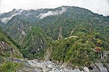
Hualien County (Chinese: 花蓮縣; pinyin: Huālián Xiàn) has the largest area of all counties in Taiwan, and is located on the country's mountainous eastern coast. It is the northern terminus of the Hualien-Taitung Line and the southern terminus of the North-Link Line of the Taiwan Railway Administration. In the Provincial Highway System, Hualien County is connected to other counties via the Suhua Highway, Huatung Highway, Hualien-Taitung Coast Highway and the Central Cross-Island Highway. Hualien County is famous for tourism. Tourism spots include the Taroko National Park and Yushan National Park and its coastline is well suited for biking purposes.
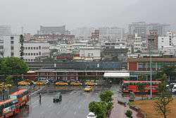
Hualien City is the county seat of Hualien County and has the largest population.
History
Modern-day Hualien City was originally called Kiray (Chinese: 奇萊; Pe̍h-ōe-jī: Kî-lâi), after the Sakiraya Taiwanese aborigines and their settlement.[2]
Spanish settlers arrived in 1622 to pan for gold. Picking up the sounds of native words, these settlers called the area Turumoan (多羅滿; To-lô-boán). Han Chinese settlers arrived in 1851. Qing Dynasty records give the name of the region as Huilan (洄瀾; Hoê-liân; "eddies") due to the whirling of waters in the delta.
Empire of Japan
During Taiwan's Japanese colonial period (1895-1945) the island's Japanese governors opted not to transliterate the name "Kiray" because the Japanese pronunciation of the word resembled the Japanese word for "dislike, disgusting" (嫌い kirai). The official name became Karen Harbour (花蓮港 Karenkō). Karenkō Prefecture consisted of modern-day Hualien County. Toward the end of World War II the Governor-General of Taiwan moved many Japanese residents of Taiwan to the area to develop agriculture.
Republic of China
After Japan's surrender in 1945, the rule of Taiwan was passed to the Kuomintang government of the Republic of China. Hualien was established as a county named Hualien County of Taiwan Province on 25 December 1945.
Few years later, the Kuomintang soon became refugees in Taiwan following the rise of Communism in China (1949) but continued to govern the island according to the Republic of China constitution. In 1951 Hualien was the first county in Taiwan to be governed according to the ROC local autonomy law.
In the 1990s Taiwan transformed itself into a self-governing multiparty democracy. Today the Hualien area serves as the key population centre on the east coast as well as the one of five main life circle regions in Taiwan. (Taipei, Taichung, Tainan, Kaohsiung)
A great white shark was caught off Hualien County on May 14, 1997. Reportedly almost 7 meters in length and weighing 4000 kg, it is the largest specimen ever recorded.
Geography
Hualien County is situated in eastern Taiwan Island. It faces the Pacific Ocean to the east, Central Mountain Range to the west bordering Taichung City, Nantou County and Kaohsiung City, Yilan County to the north and Taitung County to the south. It stretches around 137.5 km from north to south with its width ranging from 27 to 43 km long from east to west. Its area is about 4,628.57 km2 and occupies one eight of Taiwan total area.
Despite its vast area, only 7% of the county area occupied by people. The remaining area is occupied by rivers (7%) and mountains (87%). Mountains are composed of Central Mountain Range in the west and Haian Range in the east. The main rivers in the county are the Hualian River, Xiuguluan River and their branches. The plains stretch along the valleys between both mountain ranges with a width around 3–6 km. Due to the restriction of its landscape, Hualien people reside mostly on the alluvial fans of the Huatung Valley plains.[3]
Government


Administrative divisions
Hualien County is divided into 1 city, 2 urban townships, 7 rural townships and 3 mountain indigenous townships. Some towns have Japanese names because these towns were named by Japanese during the Japanese ruling period from 1895 to 1945. Hualien City is the county seat and houses the Hualien County Government and Hualien County Council. The current Magistrate of Hualien County is non-partisan Fu Kun-chi.[4]
| English | Japanese |
|---|---|
| City | |
| Hualien City (花蓮市) | Karen (花蓮) |
| Urban townships | |
| Fenglin Township (鳳林鎮) | |
| Yuli Township (玉里鎮) | Tamasato (玉里) |
| Rural townships | |
| Fengbin Township (豐濱鄉) | Toyohama (豊浜) |
| Fuli Township (富里鄉) | Tomisato (富里) |
| Guangfu Township (光復鄉) | |
| Ji'an Township (吉安鄉) | Yoshiyasu (吉安) |
| Ruisui Township (瑞穗鄉) | Mizuho (瑞穂) |
| Shoufeng Township (壽豐鄉) | |
| Xincheng Township (新城鄉) | |
| Mountain indigenous townships | |
| Wanrong Township (萬榮鄉) | |
| Xiulin Township (秀林鄉) | |
| Zhuoxi Township (卓溪鄉) | |
Politics
Hualien County voted one Democratic Progressive Party legislator to be in the Legislative Yuan during the 2016 Republic of China legislative election.[5]
Demographics and culture
| Historical population | ||
|---|---|---|
| Year | Pop. | ±% |
| 1985 | 361,549 | — |
| 1990 | 352,233 | −2.6% |
| 1995 | 358,981 | +1.9% |
| 2000 | 353,630 | −1.5% |
| 2005 | 345,303 | −2.4% |
| 2010 | 338,805 | −1.9% |
| 2015 | 331,945 | −2.0% |
| Source:"Populations by city and country in Taiwan". Ministry of the Interior Population Census. | ||
.svg.png)
Population
Hualien County has 333,392 inhabitants as of December 2014 and is divided into 1 city and 12 townships. Its late development means that many aboriginal cultures such as Ami, Atayal, Bunun, Truku, Sakizaya and Kavalan are well-preserved. As of 2014, aborigines make up 27.5% of the population of Hualien County (about 91,675).[6] The Hakka people comprise about 30% of inhabitants.[1]
The county has seen a negative population growth over the past few years due to emigration to other places outside Hualien County with an average reduction of 1,393 people per year over the past 18 years.
According to a 2015 survey on national happiness index, Hualien County was rated as the happiest place to live in Taiwan among other 20 counties and cities due to the residents happiness driven by strong levels of satisfaction with work-life balance, living condition, education, environmental quality and the performance of the local government.[7]
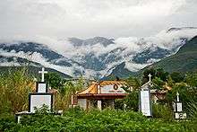
Belief
The internationally famous Buddhist Tzu Chi foundation is headquartered in Hualien City. There are also many temples around the county. Buddhism and Folk religions are popular in Hualien County.[8] Hualien County also has the highest concentration of Roman Catholics in Taiwan at 9.46% of the population.[9]
Sports
Hualien County is home to the Hualien Stadium and Hualien Baseball Stadium.
Because of its awesome scenic view, fresh air, fine weather, and plenty of well-maintained bike trails, Hualien County is a popular destination for cyclist enthusiasts and marathon runners. Many cycling tournaments and marathon events are held each year in Hualien County. For example, Taiwan KOM Challenge[10] and Taroko Gorge Marathon.[11]
Education
The Hualien County Department of Education lists in all 6 institutions of higher learning within the county's borders as well as 15 high schools, 35 junior high schools and 151 elementary schools, though some of the listed elementary campuses have been closed for years due to their remote location or to low enrollments. Hualien County is home to National Dong Hwa University, Tzu Chi University, Taiwan Hospitality and Tourism University, Dahan Institute of Technology and Tzu Chi College of Technology.
Energy

Hualien County houses the hydroelectric Bihai Power Plant with an installed capacity of 61.2 MW and coal-fired Hoping Power Plant with a capacity of 1,320 MW, the fourth largest coal-fired power plant in Taiwan. Both power plants are located in Xiulin Township.
Tourist attractions
Hualien County boasts many tourist attractions from nature to museums.
Nature
National parks in the county are Taroko National Park and Yushan National Park. The county is also home to several mountains and cliffs, such as Hehuan Mountain, Pingfeng Mountain, Qilai Mountain and Qingshui Cliff. Other nature tourism includes the Liyu Lake, Rareseed Ranch and Chihsingtan Beach.
Museums
Museums and historical buildings in Hualien County are Pine Garden, Chihsing Tan Katsuo Museum and Hualien County Stone Sculptural Museum.
Theme parks
Theme parks in the county is Farglory Ocean Park.
Temples and shrines
Places of worship or shrines are Hualien Martyrs' Shrine, Eternal Spring Shrine and Xiangde Temple.
Transportation

- Hualien Airport
- Taiwan Railway Administration - North-Link Line and Hualien-Taitung Line
- Provincial Highway No.8 (Central Cross-Island Highway)
- Provincial Highway No. 9 (Su'ao-Hualien and Hualien-Taitung Highway)
- Provincial Highway No. 11 (Hualien-Taitung Coast Highway)
- Provincial Highway No. 14
- Provincial Highway No. 16
- Provincial Highway No. 23 (Fuli-Donghe Highway)
- Provincial Highway No. 30 (Yuchang Highway)
- County Road No.193
- Port of Hualien
- Heping Cement Port
Gallery
 Cyclists at Fuli Township
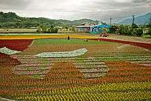 Farmers paint with flowers
 Farmer's residence
 Rice Paddy
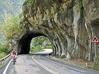 Biking at Taroko Gorge
 Bus on the narrow road
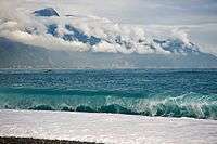 Qixingtan with the Central Mountain Range in the background.
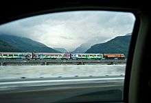 Formosa Express tourist train
 The Chihsing Tan Katsuo Museum and former fish-flake factory
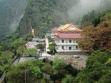 Xiangde Temple
 Jiqi Bay
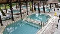 Hot Spring & Spa at Deluxe Butterfly Valley Resort
 River in Butterfly Valley
Relative location
 |
|
| ||
| |
|
Philippines Sea (Pacific Ocean) | ||
| ||||
| | ||||
| |
See also
References
- 1 2 "Aborigines now make up 28% of Hualien County".
- ↑ "撒奇萊雅族_認識本族". TAIWAN INDIGENOUS PEOPLES CULTURE PARK. Retrieved 3 December 2014.
- ↑ "縣府各樓層平面圖 - 花蓮縣政府全球資訊服務網-首頁".
- ↑ "INTERVIEW: Hualien commissioner Fu targets debt".
- ↑ "2016 The 14th Presidential and Vice Presidential Election and The 9th Legislator Election".
- ↑ "Amis remains Taiwan's biggest aboriginal tribe at 37.1% of total".
- ↑ http://www.chinapost.com.tw/taiwan/local/hualien/2015/10/02/447335/Hualien-County.htm
- ↑ "花蓮市公所-英文版-".
- ↑ Cheney, David M. "Mr". Catholic Hierarchy. Retrieved 11 July 2016.
- ↑ "2015 Taiwan KOM Challenge".
- ↑ "Taroko Gorge Marathon 2016". Event Carnival.
External links
| Wikimedia Commons has media related to Hualien County. |
- Hualien County Government Website (Chinese) (English)
- East Coast National Scenic Area
- Taroko National Park
- Hualien delicious cuisine Introduction
- Ah-Taiwan: Life in Formosa - Taichung to Hualien
- Hualien Outdoors - Hiking and River Tracing Information in Hualien County
| Special municipalities (6) |  | |
|---|---|---|
| Provincial cities (3) | ||
| Counties (13) | ||
| ||
Cities and townships of Hualien County | ||
|---|---|---|
| Cities | | |
| Urban townships | ||
| Rural townships | ||
| Mountain indigenous townships | ||