Humber Forts
The Humber Forts are two large fortifications in the mouth of the Humber estuary in northern England: Haile Sand Fort (53°32′4″N 0°2′1″E / 53.53444°N 0.03361°E)[1] and Bull Sand Fort (53°33′43″N 0°4′3″E / 53.56194°N 0.06750°E).[2]
History
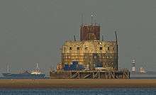
The two forts were planned in 1914 to protect the entrance to the estuary. They stand 59 feet (18 m) above the water and have a diameter of 82 feet (25 m). There was accommodation for 200 soldiers. Started in May 1915, they took more than four years to build and construction was not finished until December 1919.
During the Second World War they were reactivated and modernised. The forts were regularly attacked by enemy aircraft. During this time, they installed a netting to prevent enemy submarines from travelling up the estuary to Hull or Grimsby. The forts were finally abandoned by the military in 1956.[1][2]
Haile Sand Fort or Sand Haile Fort[3] is the smaller of the two and is situated around the low-water mark between Cleethorpes and Humberston on the Lincolnshire coast.[1] In February 2016 the fort was put on the market for £350,000.[4]
Haile sand fort was reduced in price in May this year, and is currently on the market for £300,000.
Bull Sand Fort is 1.5 miles (2.4 km) from shore off Spurn Head. It is a 4-storey concrete building with 12-inch (300 mm) of armour on the seaward side, and originally armed with four 6-inch guns.[5] It was built with great difficulty as its sandbank is 11 feet (3.4 m) below low water.
In 1987 it was given a Grade II Listed Building status.[2][6] In 1997 it was sold to the Streetwise Charitable Trust, who are restoring the fort for use as a drug rehabilitation facility.[7][8] Administratively, it is within the East Riding of Yorkshire and civil parish of Easington, East Riding of Yorkshire.[9]
See also
References
- 1 2 3 Historic England. "Haile Sands Fort (1429147)". PastScape. Retrieved 13 December 2012.
- 1 2 3 Historic England. "Bull Sand Fort (915963)". PastScape. Retrieved 13 December 2012.
- ↑ Oliver, Richard (August 2012). "Filling the gap" (PDF). Sheetlines The journal of THE CHARLES CLOSE SOCIETY for the Study of Ordnance Survey Maps. 94. Retrieved 4 April 2016.
- ↑ "Haile Sand wartime fortress for sale". BBC News. BBC. 24 February 2016. Retrieved 24 February 2016.
- ↑ "Bull Sand Fort (TA371092)" (PDF). Retrieved 22 March 2013.
- ↑ Historic England. "Details from image database (166549)". Images of England. Retrieved 13 December 2012.
- ↑ "History of the Project". An Island of Hope. Streetwise Charitable Trust. Retrieved 22 March 2013.
- ↑ "Drugs detox plan for WWI fort". BBC News Online. BBC. 22 May 2006. Retrieved 11 July 2008.
- ↑ John Morris Associates. "Southfield Farm Wind Turbine Landscape and Visual Assessment" (PDF). East Riding of Yorkshire Council. p. 61. Retrieved 31 January 2015.
External links
 Media related to Bull Sand Fort at Wikimedia Commons
- Media related to Haile Sand Fort at Wikimedia Commons
- Humber Forts page on North East Lincolnshire Council website
- Island of Hope Charitable Trust