Hurricane Danielle (2010)
| Category 4 major hurricane (SSHWS/NWS) | |
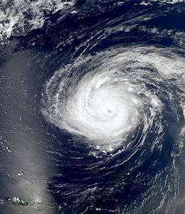 Hurricane Danielle at peak intensity on August 27 | |
| Formed | August 21, 2010 |
|---|---|
| Dissipated | September 3, 2010 |
| (Extratropical after August 30) | |
| Highest winds |
1-minute sustained: 130 mph (215 km/h) |
| Lowest pressure | 942 mbar (hPa); 27.82 inHg |
| Fatalities | 1 direct |
| Damage | Minimal |
| Areas affected | Bermuda, United States East Coast |
| Part of the 2010 Atlantic hurricane season | |
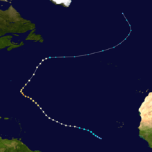
Hurricane Danielle was the first of four Category 4 hurricanes during the 2010 Atlantic hurricane season.[1] The sixth tropical depression, fourth named storm, second hurricane, and first major hurricane of the season,[2] Danielle developed as a typical Cape Verde-type hurricane from a tropical wave on August 21. Quickly intensifying, the new tropical depression became a tropical storm eighteen hours after formation on August 22, and it reached category 2 on August 24. Also on August 24, Hurricane Danielle weakened back to a category 1 hurricane, but it returned to category 2 strength on August 25. Further intensification occurred and Danielle became a Category 4 hurricane with peak winds of 130 miles per hour (210 km/h) on August 27. It then weakened, and finally dissipated on August 30. The hurricane was the first in a rapid succession of eleven named storms, which ended in late September.[1]
Meteorological history
On August 20, a tropical wave that had formed two days earlier off Africa's western coast interacted with a large tropical disturbance in the Intertropical Convergence Zone.[3] This disorganized disturbance covered an area from the southwest of Senegal to the south of the Cape Verde Islands while slowly moving west. The National Hurricane Center (NHC) began monitoring the system, initially giving this area of disturbed weather a 20% chance of development.[4] As it moved through favorable conditions, the system became more organized and began circulating at a low level. On August 20, 8:00 am EDT, the National Hurricane Center gave the disturbance a 40% chance of becoming a tropical cyclone during the following 48 hours.[3][5] The NHC stated that a broad area of low pressure had formed, and conditions were favorable for further development. The system continued to organize, and the chance was raised to the "high" category on August 21 at 2:00 pm EDT, indicating at least 60% probability of development into a tropical cyclone within the following 48 hours.[6] The tropical disturbance became banded and the convection became even more organized.[3]
Late that afternoon, the system was designated as Tropical Depression Six.[7] As the depression tracked slowly westward, it quickly intensified. The following day, it was upgraded to Tropical Storm Danielle, the fourth tropical storm of the season.[8] Slow intensification ensued as Danielle headed generally westward and eventually became the second hurricane of the season on August 23, with hurricane-force winds extending outward for a 10-mile (16 km) radius.[1][9] Hurricane Danielle reached an initial peak intensity on August 24 at category 2 with a maximum wind speed of 100 mph (160 km/h; 87 kn) and hurricane-force winds extending out for 30 miles (48 km),[10] However, later that day, Danielle began to rapidly weaken as it encountered an area of high wind shear and dry air. Danielle weakened to a category 1 hurricane with 75 mph (121 km/h; 65 kn) winds late on August 24.[3] Danielle quickly re-intensified early on the night of August 24–25, and it had hurricane-force winds in a 30 miles (48 km) radius from the center.[11] Further intensification was gradual, and Danielle again reached category 2 strength late on August 25, and an eye was present on satellite images. It had hurricane-force winds extending outwards 40 miles (64 km) from the center.[12] After a few days of gradual strengthening, Danielle began to rapidly intensify on August 27, and became the first major hurricane of the season with winds of 120 mph (190 km/h; 100 kn). Hurricane-force winds extended out for 50 miles (80 km), and tropical storm-force winds extended out for 205 miles (330 km).[13] Continuing the rapid intensification, Hurricane Danielle briefly became a category 4 hurricane on August 27, when it was situated 545 miles (877 km) southeast of Bermuda, attaining its peak intensity with winds of 135 mph (217 km/h; 117 kn) and a minimum barometric pressure of 94.2 kPa (27.82 inHg). The hurricane-force winds were in a radius of 60 miles (97 km), and the tropical storm-force winds extended out for 205 miles (330 km) from the center.[14]
However, on August 28, Danielle encountered a large middle-level to upper-level weather trough moving off the coast of the eastern United States into the Atlantic Ocean. This pushed Danielle north-northeast.[3][15] The inner of Danielle's two eye walls eroded as the hurricane weakened.[16] During this time, Hurricane Danielle's outflow exposed the core of the more southerly Hurricane Earl. However, Hurricane Earl (then a tropical storm) retained strong circulation, and the center eventually moved back into the convection flow.[17] The outflow from Danielle kept Earl a tropical storm before Danielle accelerated north and northeastward.[18] As Danielle moved into a region with cooler sea surface temperatures and higher wind shear, it began to weaken at a steady pace and slowly began its extratropical transition. Danielle weakened to a category 1 hurricane on August 29, and became a tropical storm on the afternoon of August 30. Accelerating northeastward, Danielle completed the extratropical transition later that day. During the next few days, the extratropical remnants of Hurricane Danielle moved across the northern Atlantic Ocean,[19] and were forecast to move into the area of Greenland and Iceland over the next five days.[20] However, on September 3, Danielle's remnants dissipated after 72 hours in the cold waters of the northern Atlantic Ocean.[3][21]
Preparations and impact
On August 27, a tropical storm watch was issued on Bermuda before being canceled during the afternoon of August 28 because Danielle turned sharply east.[3] However, it still triggered an advisory concerning high surf and large waves on Bermuda.[22]
Hurricane Danielle and Hurricane Earl caused strong ocean swells and rip currents on the coasts of New Jersey, Delaware, and Maryland.[23] which swept people out to sea. In Florida, around 250 people from Ocean City were swept out to sea, and at least one person was drowned by the riptides. At least 70 more people had to be rescued off the remaining coast of eastern central Florida.[24] On August 31, despite being more than 475 miles (764 km) from Newfoundland, Tropical Storm Danielle still caused 10 feet (3.0 m) waves on its shores.[25]
Researchers exploring the sunken remnants of the RMS Titanic were forced to leave the area when Danielle approached on August 29.[26]
See also
- Timeline of the 2010 Atlantic hurricane season
- 2010 Atlantic hurricane season
- Other storms of the same name
References
- 1 2 3 "Hurricane Season 2010 Scorecard". The Weather Channel. Retrieved January 23, 2011.
- ↑ "Review of the 2010 Atlantic Hurricane Season". National Weather Service Weather Forecast Office. National Oceanic and Atmospheric Administration. Retrieved January 23, 2011.
- 1 2 3 4 5 6 7 Kimberlain, Todd B. (December 15, 2010). "Tropical Cyclone Report on Hurricane Danielle" (PDF). National Hurricane Center. Retrieved January 25, 2011.
- ↑ Berg, Robbie / Pasch, Richard (August 19, 2010). "Tropical Weather Outlook, 2 p.m. EDT, August 19, 2010". National Hurricane Center. Retrieved November 3, 2010.
- ↑ Blake, Erik (August 20, 2010). "Tropical Weather Outlook, 8 a.m. EDT, August 20, 2010". National Hurricane Center. Retrieved November 3, 2010.
- ↑ Blake, Erik (August 21, 2010). "Tropical Weather Outlook, 2 p.m. EDT, August 21, 2010". National Hurricane Center. Retrieved November 3, 2010.
- ↑ Blake, Erik (August 21, 2010). "Tropical Depression Six Advisory Number One". National Hurricane Center. Retrieved November 3, 2010.
- ↑ Berg, Robbie (August 22, 2010). "Tropical Storm Danielle Advisory Number Five". National Hurricane Center. Retrieved November 3, 2010.
- ↑ Berg, Robbie (August 23, 2010). "Hurricane Danielle Advisory Number Nine". National Hurricane Center. Retrieved November 3, 2010.
- ↑ Kimberlain, Todd (August 24, 2010). "Hurricane Danielle Advisory Number Eleven". National Hurricane Center. Retrieved November 3, 2010.
- ↑ Berg, Robbie (August 24, 2010). "Hurricane Danielle Advisory Number Fourteen". National Hurricane Center. Retrieved November 3, 2010.
- ↑ Blake, Erik (August 25, 2010). "Hurricane Danielle Advisory Number Eighteen". National Hurricane Center. Retrieved November 3, 2010.
- ↑ Brennan, Michael (August 27, 2010). "Hurricane Danielle Advisory Number Twenty-Three". National Hurricane Center. Retrieved November 3, 2010.
- ↑ Brennan, Michael (August 27, 2010). "Hurricane Danielle Advisory Number Twenty-Four". National Hurricane Center. Retrieved November 3, 2010.
- ↑ Roberts; Avila (August 28, 2010). "Hurricane Danielle Discussion 30". National Hurricane Center. Retrieved January 23, 2011.
- ↑ Brennan (August 28, 2010). "Hurricane Danielle Discussion 28". National Hurricane Center. Retrieved January 23, 2011.
- ↑ Avila (August 28, 2010). "Tropical Storm Earl Discussion 14". National Hurricane Center. Retrieved January 23, 2011.
- ↑ Brennan (August 29, 2010). "Tropical Storm Earl Discussion 16". National Hurricane Center. Retrieved January 23, 2011.
- ↑ Kimberlain, Todd (August 31, 2010). "Hurricane Danielle Advisory Number Thirty-Nine". National Hurricane Center. Retrieved November 3, 2010.
- ↑ Huttner, Paul (August 30, 2010). "Atlantic Roars: Tropical Storm in Iceland?". Minnesota Public Radio. Retrieved January 24, 2011.
- ↑ Prosise, Scott (2010). 2010 Hurricane Season (PPT). NOAA Hurricane Conference. Tim Holley and Matthew Glazewski. Ocean Prediction Center. Retrieved January 24, 2011.
- ↑ CNN Wire Staff (August 27, 2010). "Bermuda Prepares for Large Waves from Hurricane Danielle". CNN. Retrieved February 10, 2011.
- ↑ Auletta, Kate (August 30, 2010). "Hurricanes Danielle & Earl Create Rough Waters For End-Of-Summer Vacationers". The Huffington Post. Retrieved January 23, 2011.
- ↑ Muskus, Jeff (August 30, 2010). "Hurricane Riptides Roil Atlantic Coast: 1 Dead, 1 Missing". The Huffington Post. Retrieved January 23, 2011.
- ↑ Gutro, Rob (August 31, 2010). "Hurricane Season 2010: Danielle (Atlantic Ocean)". Hurricanes/Tropical Cyclones. National Aeronautics and Space Administration. Retrieved January 23, 2011.
- ↑ "Titanic Explorers Take Cover from Hurricane". CBC News. August 30, 2011. Retrieved July 16, 2011.
External links
| Wikimedia Commons has media related to Hurricane Danielle (2010). |
Tropical cyclones of the 2010 Atlantic hurricane season | ||
|---|---|---|
 | ||
| ||