Iecava (river)
| Iecava | |
|---|---|
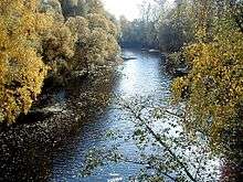 The Iecava river in autumn near Ozolnieki village | |
| Country |
|
| Basin | |
| Main source | Jaunjelgava Municipality, Latvia |
| River mouth | Lielupe, Latvia |
| Basin size | 2,172 km2 (839 sq mi)[1] |
| Physical characteristics | |
| Length | 155 km (96 mi)[2] |
The Iecava is a river in Latvia. Its source is formed from several springs near the village of Daudzese in Jaunjelgava municipality. Its mouth is located 4 km below the town of Jelgava on the Lielupe river.[3]
The Iecava river flows through Taurkalne and Upmale low land where its river banks are mainly wooded.[4] Near the town of Iecava it crosses the Zemgale low land and it reaches Lielupe river in Tīreļi low land.
The main water source (more than 50%) for the Iecava is meltwater from melting snow, whereas water from groundwaters is minimal (4-5%); as a result the river is usually in spate in the springs and has low water level in summers.[5]
The Iecava has around 400 tributaries (including rivers, streams and ditches),[6] the biggest of them are:
Left bank:
Kuma - 6 km
Ģirupe - 12 km
Smārde - 12 km
Ģedulis - 11 km
Īkstrums - 23 km:
Right bank:
Sudmaļupe - 6 km
Svētupe 6 km
Dzērvīte - 11 km
Briede - 10 km
Vēršupe - 15 km
Smakupe 26 km
Jāņupe - 20 km
Biržiņa - 16 km
Misa - 108 km
References
- ↑ Lielāko upju un to baseinu izvietojums (The location of the biggest rivers and their basins in Latvia, in Latvian)
- ↑ Lielāko upju un to baseinu izvietojums (The location of the biggest rivers and their basins in Latvia, in Latvian)
- ↑ Lielāko upju un to baseinu izvietojums (The location of the biggest rivers and their basins in Latvia, in Latvian)
- ↑ Lielāko upju un to baseinu izvietojums (The location of the biggest rivers and their basins in Latvia, in Latvian)
- ↑ Lielāko upju un to baseinu izvietojums (The location of the biggest rivers and their basins in Latvia, in Latvian)
- ↑ Lielāko upju un to baseinu izvietojums (The location of the biggest rivers and their basins in Latvia, in Latvian)
| Wikimedia Commons has media related to Iecava river. |
Coordinates: 56°41′13″N 23°41′58″E / 56.6869°N 23.6994°E