Isle of Pines (New Caledonia)
| Native name: <span class="nickname" ">Île des Pins Kunyié Nickname: l'île la plus proche du paradis | |
|---|---|
|
Upi Bay, Isle of Pines, New Caledonia | |
| Geography | |
| Archipelago | New Caledonia |
| Administration | |

The Isle of Pines (French: Île des Pins; name in Kanak language Kwênyii: Kunyié) is an island located in the Pacific Ocean, in the archipelago of New Caledonia, an overseas collectivity of France. The island is part of the commune (municipality) of L'Île-des-Pins, in the South Province of New Caledonia. The Isle of Pines is nicknamed l'île la plus proche du paradis ("the closest island to Paradise"). It has snorkeling and scuba diving in and around its lagoon. Species of tropical fish and corals can be seen in the transparent water.
The island is around 22°37′S 167°29′E / 22.617°S 167.483°ECoordinates: 22°37′S 167°29′E / 22.617°S 167.483°E and measures 15 km (9.3 mi) by 13 km (8.1 mi). It lies southeast of Grande Terre, New Caledonia's main island and is 100 kilometres (62 mi) southeast of the capital Nouméa. There is one airport (code ILP) with a 1,097 m (3,599 ft) runway. The Isle of Pines is surrounded by the New Caledonia Barrier Reef.
The inhabitants of the island are mainly native Melanesian Kanaks and the population is 2,000 (estimated 2006) (1989 population 1,465).
The island is rich with animal life and is home to unusual creatures such as the Crested Gecko Rhacodactylus ciliatus and the world's largest gecko Rhacodactylus leachianus.
The pic Nga is the island's highest point, at 262 metres (860 ft) elevation. River Ouro is the longest river.
History
Melanesian people lived of the island for over 2000 years before the island was first visited by Europeans. Captain James Cook in 1774 saw the island and renamed it on his second voyage to New Zealand. Cook gave the island its name after seeing the tall native pines (Araucaria columnaris). He never disembarked onto the island, but as he saw signs of inhabitance (smoke) assumed it was inhabited. In the 1840s Protestant and Catholic missionaries arrived, along with merchants seeking sandalwood.
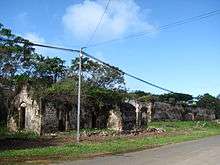
The French took possession of the island in 1853 at which time the native Kunies opted for the Catholic religion. In 1872 the island became a French penal colony, home to 3,000 political deportees from the Paris Commune.
Sights
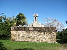
The ruins of a penal colony can be seen in the village of Ouro in the west of the island. The water tower of Ouro which was built by prisoners in 1874/75 and renovated in 2005 is still used today.
On the cemetery Cimetière des Déportés near Ouro a pyramide-shaped memorial and the graves of 300 deportees who died here between 1872 and 1880 can be seen.
External links
| Wikivoyage has a travel guide for Île des Pins. |
| Wikimedia Commons has media related to Île des Pins. |
- (English) www.isle-of-pines.com General and tourist information about the Isle of Pines
- Audio interview with Isle of Pines resident about life on the Isle of Pines
- Jane's Isle of Pines Page
- Isle of Pines photos
![]() Île des Pins travel guide from Wikivoyage
Île des Pins travel guide from Wikivoyage