Ilola
| Ilola Gladas | |
|---|---|
| City District | |
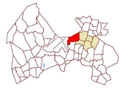 Location on the map of Vantaa, with the district in red and the Koivukylä major region in light brown | |
| Coordinates: 60°19′44″N 25°00′50″E / 60.32889°N 25.01389°ECoordinates: 60°19′44″N 25°00′50″E / 60.32889°N 25.01389°E | |
| Country |
|
| City |
|
| Major region | Koivukylä |
| Area | |
| • Total | 3.9 km2 (1.5 sq mi) |
| Population (1.1.2014)[1] | |
| • Total | 4,578 |
| • Density | 1,200/km2 (3,000/sq mi) |
| Time zone | GMT +2 |
| Postal Code(s) | 01390 |
| Website |
web |
Ilola (Swedish: Gladas) is a city district of the municipality of Vantaa, Finland. It is located in the northern part of the administrative district of Koivukylä. It is bordered to the west by the district of Lentokenttä, to the south by Ruskeasanta, to the east by Asola, and to the north by the municipality of Tuusula. Ilola has a population of 4,578 (as of 1.1.2014), and its housing is mostly owner-occupied separate and terraced houses, with an average size particularly high for Vantaa, at 90 square metres (970 sq ft). The district was primarily developed in the 1980s and 1990s, when it was one of Vantaa's fastest growing districts.
References
- ↑ Vantaan väestö 2013/2014 (PDF) (Report). Vantaa: City of Vantaa, Tietopalveluyksikkö. 20 August 2014. p. 33. ISBN 978-952-443-480-5. Archived from the original (PDF) on February 2, 2015. Retrieved May 2015. Check date values in:
|access-date=(help)
| Myyrmäki (Myrbacka) area |
|  |
|---|---|---|
| Kivistö area |
| |
| Aviapolis area |
| |
| Tikkurila (Dickursby) area |
| |
| Koivukylä (Björkby) area |
| |
| Korso area |
| |
| Hakunila (Håkansböle) area |
| |
This article is issued from Wikipedia - version of the 11/29/2016. The text is available under the Creative Commons Attribution/Share Alike but additional terms may apply for the media files.