Indiana State Road 110
| ||||
|---|---|---|---|---|
 | ||||
| Route information | ||||
| Maintained by INDOT | ||||
| Length: | 18.880 mi[1] (30.384 km) | |||
| Western segment | ||||
| Length: | 2.485 mi[1] (3.999 km) | |||
| West end: |
| |||
| East end: |
| |||
| Eastern segment | ||||
| Length: | 16.395 mi[1] (26.385 km) | |||
| West end: |
| |||
| Major junctions: |
| |||
| East end: |
| |||
| Location | ||||
| Counties: | Fulton, Jasper, Marshall | |||
| Highway system | ||||
| ||||

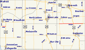
State Road 110 in Northern Indiana consists of two discontinuous east–west segments. Neither segment passes through any towns.
Route description
The western portion of State Road 110 is 2.5 miles (4.0 km) long and connects State Road 10 with U.S. Route 231 in Jasper County.
The eastern portion runs along the border between Fulton County and Marshall County; it is 16.4 miles (26.4 km) long and connects State Road 17 at the west end with State Road 25 at the east end, and has an interchange with U.S. Route 31 south of Argos.
Major intersections
| County | Location | mi[1] | km | Destinations | Notes | ||
|---|---|---|---|---|---|---|---|
| Jasper | Keener Township | 0.000 | 0.000 | Western terminus of SR 110 | |||
| Walker Township | 2.485 | 3.999 | Eastern terminus of the western section of SR 110 | ||||
| Gap in route | |||||||
| Marshall | Union Township | 2.486 | 4.001 | Western terminus of the eastern section of SR 110 | |||
| 5.324 | 8.568 | Southern terminus of SR 117 | |||||
| Walnut Township | 12.552 | 20.200 | |||||
| Tippecanoe Township | 18.880 | 30.384 | Eastern terminus of SR 110 | ||||
| 1.000 mi = 1.609 km; 1.000 km = 0.621 mi | |||||||
References
- 1 2 3 4 Indiana Department of Transportation (July 2015). Reference Post Book (PDF). Indianapolis: Indiana Department of Transportation. Retrieved October 13, 2016.
External links
This article is issued from Wikipedia - version of the 10/13/2016. The text is available under the Creative Commons Attribution/Share Alike but additional terms may apply for the media files.