Indiana State Road 144
| ||||
|---|---|---|---|---|
 | ||||
| Route information | ||||
| Maintained by INDOT | ||||
| Length: | 11.964 mi[1] (19.254 km) | |||
| Western section | ||||
| Length: | 7.155 mi[1] (11.515 km) | |||
| West end: |
| |||
| East end: |
| |||
| Eastern section | ||||
| Length: | 4.808 mi[1] (7.738 km) | |||
| West end: |
| |||
| East end: |
| |||
| Location | ||||
| Counties: | Morgan, Johnson | |||
| Highway system | ||||
| ||||

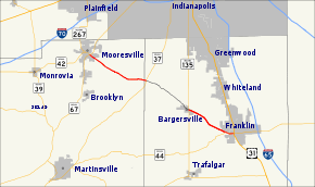
State Road 144 in the U.S. State of Indiana is a highway that exists in two short sections south of Indianapolis.
History
It was formerly Indiana State Road 267. It was combined with Indiana State Road 44 and ended at US 31 in Franklin.
Route Description
The western half section has a west terminus at Indiana State Road 67 in Mooresville and has an east terminus at Indiana State Road 37 near Waverly. The eastern half section has a west terminus at Indiana State Road 135 in Bargersville and has an east terminus at Indiana State Road 44 in Franklin.The middle one-third of its run, from Indiana State Road 37 in the west to Indiana State Road 135 to the east is known as CR 144. It was previously signed with County Road 144 signs at its west and east ends at 37 and 135 respectively. It is also known as Old Plank Road in Bargersville. It is one of the very few county roads in Indiana with a numerical designation identical to that of an adjoining state road, similar to how it is done in Florida.
Major intersections
| County | Location | mi[1] | km | Destinations | Notes | ||
|---|---|---|---|---|---|---|---|
| Morgan | Mooresville | 0.000 | 0.000 | Western terminus of SR 144; route continues west as SR 42 | |||
| Johnson | White River Township | 7.155 | 11.515 | Eastern terminus of the western section of SR 144. Proposed future I-69 Interchange. Route continues east as CR 144 | |||
| Gap in route | |||||||
| Bargersville | 7.156 | 11.516 | Western terminus of the eastern section of SR 144. Route continues west as CR 144 | ||||
| Franklin | 11.964 | 19.254 | Eastern terminus of the western section of SR 44;[2] Eastern terminus of SR 144; Route continues as West Jefferson Street | ||||
| 1.000 mi = 1.609 km; 1.000 km = 0.621 mi | |||||||
References
- 1 2 3 4 Indiana Department of Transportation (July 2015). Reference Post Book (PDF). Indianapolis: Indiana Department of Transportation. Retrieved September 22, 2016.
- ↑ "Franklin takes control of highway through city". Archived from the original (web) on October 22, 2014.