Bargersville, Indiana
| Bargersville, Indiana | |
|---|---|
| Town | |
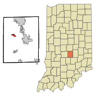 Location in the state of Indiana | |
| Coordinates: 39°31′12″N 86°9′56″W / 39.52000°N 86.16556°WCoordinates: 39°31′12″N 86°9′56″W / 39.52000°N 86.16556°W | |
| Country | United States |
| State | Indiana |
| County | Johnson |
| Townships | White River, Union |
| Area[1] | |
| • Total | 4.93 sq mi (12.77 km2) |
| • Land | 4.93 sq mi (12.77 km2) |
| • Water | 0 sq mi (0 km2) |
| Elevation[2] | 820 ft (250 m) |
| Population (2010)[3] | |
| • Total | 4,013 |
| • Estimate (2012)[4] | 6,217 |
| • Density | 814.0/sq mi (314.3/km2) |
| Time zone | EST (UTC-5) |
| • Summer (DST) | EST (UTC-5) |
| ZIP code | 46106 |
| Area code | 317 |
| FIPS code[2][5] | 18-03394 |
| GNIS ID[2][5] | 430487 |
| Website |
www |
Bargersville is a town in White River and Union townships, Johnson County, Indiana, United States. The population was 4,013 at the 2010 census.
History
Bargersville was established in 1906 when the railroad was extended to that point. It took its name from Old Bargersville, Indiana.[6]
Geography
Bargersville is located at 39°31′12″N 86°9′56″W / 39.52000°N 86.16556°W (39.519928, -86.165570).[7]
According to the 2010 census, Bargersville has a total area of 4.93 square miles (12.77 km2), all land.[1]
Demographics
| Historical population | |||
|---|---|---|---|
| Census | Pop. | %± | |
| 1880 | 77 | — | |
| 1920 | 290 | — | |
| 1930 | 282 | −2.8% | |
| 1940 | 297 | 5.3% | |
| 1950 | 413 | 39.1% | |
| 1960 | 586 | 41.9% | |
| 1970 | 873 | 49.0% | |
| 1980 | 1,647 | 88.7% | |
| 1990 | 1,681 | 2.1% | |
| 2000 | 2,120 | 26.1% | |
| 2010 | 4,013 | 89.3% | |
| Est. 2015 | 6,846 | [8] | 70.6% |
2010 census
As of the 2010 census,[3] there were 4,013 people, 1,492 households, and 1,055 families residing in the town. The population density was 814.0 inhabitants per square mile (314.3/km2). There were 1,692 housing units at an average density of 343.2 per square mile (132.5/km2). The racial makeup of the town was 95.6% White, 1.1% African American, 0.3% Native American, 1.0% Asian, 0.4% from other races, and 1.6% from two or more races. Hispanic or Latino of any race were 2.1% of the population.
There were 1,492 households of which 41.0% had children under the age of 18 living with them, 56.0% were married couples living together, 9.9% had a female householder with no husband present, 4.8% had a male householder with no wife present, and 29.3% were non-families. 21.8% of all households were made up of individuals and 5% had someone living alone who was 65 years of age or older. The average household size was 2.69 and the average family size was 3.18.
The median age in the town was 33.2 years. 29.2% of residents were under the age of 18; 7.2% were between the ages of 18 and 24; 32.6% were from 25 to 44; 23.2% were from 45 to 64; and 7.7% were 65 years of age or older. The gender makeup of the town was 51.2% male and 48.8% female.
2000 census
As of the 2000 census,[10] there were 2,120 people, 770 households, and 588 families residing in the town. The population density was 1,941.4 people per square mile (751.0/km²). There were 787 housing units at an average density of 720.7 per square mile (278.8/km²). The racial makeup of the town was 99.10% White, 0.05% African American, 0.19% Native American, 0.14% Asian, 0.05% from other races, and 0.47% from two or more races. Hispanic or Latino of any race were 0.47% of the population.
There were 770 households out of which 43.0% had children under the age of 18 living with them, 60.3% were married couples living together, 11.6% had a female householder with no husband present, and 23.6% were non-families. 18.8% of all households were made up of individuals and 5.1% had someone living alone who was 65 years of age or older. The average household size was 2.74 and the average family size was 3.12.
In the town the population was spread out with 30.4% under the age of 18, 8.8% from 18 to 24, 35.0% from 25 to 44, 19.4% from 45 to 64, and 6.5% who were 65 years of age or older. The median age was 31 years. For every 100 females there were 100.9 males. For every 100 females age 18 and over, there were 97.6 males.
The median income for a household in the town was $48,264, and the median income for a family was $50,417. Males had a median income of $37,139 versus $24,205 for females. The per capita income for the town was $19,499. About 3.7% of families and 4.3% of the population were below the poverty line, including 5.1% of those under age 18 and 1.3% of those age 65 or over.
Education
Most of Bargersville is in Center Grove Community School Corporation, served by Center Grove High School. Small sections of Bargersville are in Franklin Community Schools, served by Franklin Community High School.[11]
References
- 1 2 "G001 - Geographic Identifiers - 2010 Census Summary File 1". United States Census Bureau. Retrieved 2015-07-13.
- 1 2 3 "Feature ID 430487". Geographic Names Information System. United States Geological Survey. Retrieved June 30, 2014.
- 1 2 "American FactFinder". United States Census Bureau. Retrieved 2012-12-11.
- ↑ "Incorporated Places and Minor Civil Divisions Datasets: Subcounty Resident Population Estimates: April 1, 2010 to July 1, 2012". United States Census Bureau. Archived from the original on June 17, 2013. Retrieved 2013-06-25.
- 1 2 "FIPS55 Data: Indiana". FIPS55 Data. United States Geological Survey. February 23, 2006. Archived from the original on June 18, 2006. Retrieved June 30, 2014.
- ↑ Baker, Ronald L. (October 1995). From Needmore to Prosperity: Hoosier Place Names in Folklore and History. Indiana University Press. p. 60. ISBN 978-0-253-32866-3.
This village, first called New Bargersville, was named for Old Bargersville, q.v., formerly called Bargersville, too. It was founded in 1906 when a railroad came through here.
- ↑ "US Gazetteer files: 2010, 2000, and 1990". United States Census Bureau. 2011-02-12. Retrieved 2011-04-23.
- ↑ "Annual Estimates of the Resident Population for Incorporated Places: April 1, 2010 to July 1, 2015". Retrieved July 2, 2016.
- ↑ "Census of Population and Housing". Census.gov. Archived from the original on May 11, 2015. Retrieved June 4, 2015.
- ↑ "American FactFinder". United States Census Bureau. Archived from the original on September 11, 2013. Retrieved 2008-01-31.
- ↑ "SCHOOL DISTRICT REFERENCE MAP (2010 CENSUS): Johnson County, IN." U.S. Census Bureau. Retrieved on December 5, 2016.
External links
Municipalities and communities of Johnson County, Indiana, United States | ||
|---|---|---|
| Cities | ||
| Towns | ||
| Townships | ||
| Unincorporated communities |
| |
| Footnotes | ‡This populated place also has portions in an adjacent county or counties | |