Indiana State Road 48
| ||||
|---|---|---|---|---|
 | ||||
| Route information | ||||
| Maintained by INDOT | ||||
| Length: | 62.426 mi[1] (100.465 km) | |||
| Existed: | October 1, 1926[2] – present | |||
| Western segment | ||||
| Length: | 29.963 mi[1] (48.221 km) | |||
| West end: |
| |||
| Major junctions: |
| |||
| East end: |
| |||
| Central segment | ||||
| Length: | 5.991 mi[1] (9.642 km) | |||
| West end: |
| |||
| East end: |
| |||
| Eastern segment | ||||
| Length: | 26.472 mi[1] (42.603 km) | |||
| West end: |
| |||
| East end: |
| |||
| Location | ||||
| Counties: | Clay, Dearborn, Greene, Monroe, Owen, Ripley, Sullivan | |||
| Highway system | ||||
| ||||

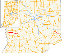
State Road 48 (SR 48) in the U.S. State of Indiana is an east–west state highway running through southern Indiana. It has three distinct and separate sections. The western terminus of SR 48 is at State Road 63 and the eastern terminus at U.S. Route 50.
Route description
Western section
The western section begins at SR 63 and heads east towards Jasonville. Passing through Shelburn at an intersection with U.S. Route 41 (US 41) and U.S. Route 150 (US 150). East of Jasonville SR 48 heads east towards Worthington. Northwest of Worthington SR 48 ends at State Road 157.[3]
Middle section
The middle section of SR 48 begins at an intersection with State Road 43 and SR 48 heads east towards Bloomington. The eastern terminus of this section is at an interchange with Indiana State Road 37 (SR 37) and State Road 45 (SR 45) in Bloomington.[4]
Eastern section
The eastern section begins at an intersection with State Road 229 and SR 48 heads east from that intersection. SR 48 passes through intersection with State Road 129, State Road 101, and State Road 148 before entering Lawrenceburg. In Lawrenceburg SR 48 has an intersection with US 50, this intersection is the eastern terminus of SR 48.[5]
Major intersections
| County | Location | mi[1] | km | Destinations | Notes | ||
|---|---|---|---|---|---|---|---|
| Sullivan | Fairbanks | 0.000 | 0.000 | Western terminus of SR 48 | |||
| Shelburn | 7.000 | 11.265 | |||||
| Clay | Coalmont | 15.908 | 25.601 | Southern terminus of SR 159 | |||
| Greene | Jasonville | 19.530 | 31.430 | ||||
| Worthington | 29.963 | 48.221 | Eastern terminus of the western section of SR 48 | ||||
| Gap in route | |||||||
| Monroe | Richland Township | 29.964 | 48.222 | Western terminus of middle section of SR 48 | |||
| Bloomington | 35.954 | 57.862 | Eastern terminus of middle section SR 48 | ||||
| Gap in route | |||||||
| Ripley | Napoleon | 35.955 | 57.864 | Western terminus of Eastern section | |||
| Delaware Township | 39.863 | 64.153 | |||||
| Franklin Township | 46.570 | 74.947 | |||||
| Dearborn | Aurora | 56.678 | 91.214 | ||||
| Lawrenceburg | 62.426 | 100.465 | Eastern terminus of SR 48 | ||||
| 1.000 mi = 1.609 km; 1.000 km = 0.621 mi | |||||||
See also
References
- 1 2 3 4 5 Indiana Department of Transportation (July 2015). Reference Post Book (PDF). Indianapolis: Indiana Department of Transportation. Retrieved October 15, 2016.
- ↑ "Road Numbers to Be Changed". The Hancock-Democrat. The Indianapolis News. September 30, 1926. Retrieved June 9, 2016 – via Newspapers.com.

- ↑ Google (2011-03-24). "overview map of the western section of SR 48" (Map). Google Maps. Google. Retrieved 2011-03-24.
- ↑ Google (2011-03-24). "overview map of the middle section of SR 48" (Map). Google Maps. Google. Retrieved 2011-03-24.
- ↑ Google (2011-03-24). "overview map of the eastern section of SR 48" (Map). Google Maps. Google. Retrieved 2011-03-24.