Indiana State Road 7
| ||||
|---|---|---|---|---|
 | ||||
| Route information | ||||
| Maintained by INDOT | ||||
| Length: | 40.8 mi[1] (65.6 km) | |||
| Major junctions | ||||
| South end: |
| |||
|
| ||||
| North end: |
| |||
| Location | ||||
| Counties: | Jefferson, Jennings, Bartholomew | |||
| Highway system | ||||
| ||||

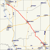
State Road 7 in the U.S. State of Indiana is located in southeast Indiana. It runs from northwest-to-southeast connecting the cities of Columbus and Madison.
History
SR 7's former terminus was in downtown Columbus. It has since been truncated east of it since SR 46 was rerouted around the city.
Major intersections
| County | Location | mi[1] | km | Destinations | Notes |
|---|---|---|---|---|---|
| Jefferson | Madison | 0.00 | 0.00 | Southern terminus of SR 7. | |
| 3.06 | 4.92 | ||||
| Lancaster Township | 7.85 | 12.63 | Eastern terminus of SR 250. | ||
| Jennings | Vernon | 21.66 | 34.86 | Southern end of SR 3 concurrency | |
| North Vernon | 23.84 | 38.37 | |||
| 24.83 | 39.96 | Northern end of SR 3 concurrency | |||
| Bartholomew | Elizabethtown | 40.31 | 64.87 | ||
| 40.76 | 65.60 | Northern terminus of SR 7 | |||
1.000 mi = 1.609 km; 1.000 km = 0.621 mi
| |||||
References
- 1 2 "INDOT Roadway Referencing System" (PDF). staff.
External links
This article is issued from Wikipedia - version of the 5/22/2016. The text is available under the Creative Commons Attribution/Share Alike but additional terms may apply for the media files.