Ingoldisthorpe
| Ingoldisthorpe | |
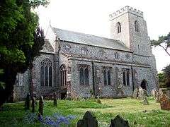 St Michael's church, Ingoldisthorpe |
|
 Ingoldisthorpe |
|
| Area | 5.63 km2 (2.17 sq mi) |
|---|---|
| Population | 849 (2011) |
| – density | 151/km2 (390/sq mi) |
| OS grid reference | TF 689 326 |
| Civil parish | Ingoldisthorpe |
| District | King's Lynn and West Norfolk |
| Shire county | Norfolk |
| Region | East |
| Country | England |
| Sovereign state | United Kingdom |
| Post town | KING'S LYNN |
| Postcode district | PE31 |
| Police | Norfolk |
| Fire | Norfolk |
| Ambulance | East of England |
| EU Parliament | East of England |
Coordinates: 52°51′52″N 0°30′27″E / 52.86438°N 0.50759°E
Ingoldisthorpe is a village and civil parish in the north-west of the English county of Norfolk. It is located approximately 9 miles (14 km) north-east of the town King's Lynn and 37 miles (60 km) from the county town of Norwich.[1]

Village sign for Ingoldisthorpe
The civil parish has an area of 5.63 km2 (2.17 sq mi) and in the 2001 census had a population of 780 in 336 households, including Sherborne the population increasing to 849 at the 2011 Census.[2] For the purposes of local government, the parish falls within the district of King's Lynn and West Norfolk.[3]
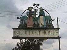
Ingoldisthorpe Village Sign
Notable residents
- William Hoste, Royal Navy captain during the Napoleonic Wars
Notes
- ↑ Ordnance Survey (2002). OS Explorer Map 250 - Norfolk Coast West. ISBN 0-319-21886-4.
- ↑ "Parish population 2011". Retrieved 28 August 2015.
- ↑ Office for National Statistics & Norfolk County Council (2001). Census population and household counts for unparished urban areas and all parishes. Retrieved December 2, 2005.
External links
| Wikimedia Commons has media related to Ingoldisthorpe. |
- Map sources for Ingoldisthorpe
- Information from Genuki Norfolk on Ingoldisthorpe.
This article is issued from Wikipedia - version of the 8/11/2016. The text is available under the Creative Commons Attribution/Share Alike but additional terms may apply for the media files.