Inishtooskert
| Native name: <span class="nickname" ">Inis Tuaisceart | |
|---|---|
_-_geograph.org.uk_-_220149.jpg) Inishtooskert, seen from the mainland | |
 Inishtooskert | |
| Geography | |
| Location | Atlantic Ocean |
| Coordinates | 52°07′50″N 10°34′42″W / 52.13045°N 10.57831°WCoordinates: 52°07′50″N 10°34′42″W / 52.13045°N 10.57831°W |
| Archipelago | Blasket Islands |
| Highest point | 172 |
| Administration | |
| Province | Munster |
| County | Kerry |
| Demographics | |
| Population | 0 |
| Inishtooskert | |
|---|---|
| Highest point | |
| Elevation | 172 m (564 ft) [1] |
| Prominence | 172 m (564 ft) [1] |
| Listing | Marilyn |
| Geography | |
| Location | County Kerry, Ireland |
| OSI/OSNI grid | Q235007 |
Inishtooskert (sometimes spelled Inishtooshkert[2]) (Inis Tuaisceart in Irish) is the northernmost of the Blasket Islands, County Kerry, Ireland.
Etymology
The Irish name means "northern island" and the English name is a phonetic spelling of the Irish name. The island is also known as An Fear Marbh (the dead man) or the sleeping giant due to its appearance when seen from the east (as in the photograph).
Nature
Inishtooskert holds important seabird colonies, as well as extensive ruins of ancient stone buildings.
Of particular note is the colony of European storm-petrels. With over 27,000 pairs in 2000 (Seabird 2000 survey), this is the largest colony in Ireland or Britain.
References
- 1 2 "Dingle West Area - Inishtooskert". MountainViews. Ordnance Survey Ireland. Retrieved June 13, 2015.
- ↑ Shima Journal
Photo gallery
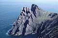 The northern cliffs of Inishtooskert
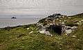 Early Medieval ecclesiastical site on the island
External links
![]() Media related to Inis Tuaisceart at Wikimedia Commons
Media related to Inis Tuaisceart at Wikimedia Commons
- Inishtooskert entry on www.earlychristianireland.org
Lists of Marilyns | |
|---|---|
This article is issued from Wikipedia - version of the 11/17/2016. The text is available under the Creative Commons Attribution/Share Alike but additional terms may apply for the media files.