Inkerman
| Inkerman Інкерман Инкерман İnkerman | |||
|---|---|---|---|
| |||
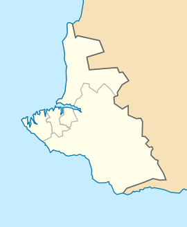 Inkerman Location of Inkerman within Sevastopol | |||
| Coordinates: 44°36′0″N 33°36′0″E / 44.60000°N 33.60000°ECoordinates: 44°36′0″N 33°36′0″E / 44.60000°N 33.60000°E | |||
| Country |
Disputed: | ||
| Region | Sevastopol | ||
| Location in Russia |
| ||
| Location in Ukraine |
| ||
| Elevation | 50 m (160 ft) | ||
| Population | |||
| • Total | 10,348 | ||
| Time zone | MSK (UTC+4) | ||
| Postal code | 299703 — 299709 | ||
| Area code | 8692 | ||
| Former names | Kalamita (until 1475), Belokamensk (1976 — 1991) | ||


Inkerman (Ukrainian: Інкерман, Russian: Инкерман, Crimean Tatar: İnkerman) is a city in the Crimean peninsula, currently subject to a territorial dispute between the Russian Federation and Ukraine. It is situated 5 kilometres east of Sevastopol, at the mouth of the Chernaya River that flows into Sevastopol Inlet (aka the North Inlet). Administratively, Inkerman is subordinate to the municipality of Sevastopol which does not constitute part of the Autonomous Republic of Crimea. Population: 10,348 (2014 Census).[1]
Inkerman is said to mean a "cave fortress" in Turkish. During the Soviet era (1976–1991) it was known as Bilokamiansk (Ukrainian: Білокам'янськ) or Belokamensk (Russian: Белокаменск), which literally means "White Stone City", as a reference to the soft white stone quarried in the area and commonly used for construction, but since then it has regained its pre-Soviet name.
History
The area has been inhabited since ancient times. The cave monastery of St. Clement was founded near Inkerman in the 8th century by Byzantine icon-venerators fleeing persecution in their homeland. The monastery was closed during the Soviet era and several of its churches destroyed but is now in restoration and brought back into use.
Kalamita (Greek: Καλαμίτα) was a medieval fortress built in the 8th-9th century on a strategic cliff overlooking the estuary and later expanded in the 14th century. In 1475 Kalamita was taken by the Turks and named Inkerman. After the Treaty of Küçük Kaynarca in 1774 the fortress was abandoned and fell into ruin, but a small settlement at the base of the cliff remained.
The town became the centre of worldwide attention in 1854 during the Crimean War, when Inkerman was the scene of the Battle of Inkerman and the Battle of Chernaya River, both victorious for the French and the British troops.
During the Soviet times, a large underground ammunition warehouse of the Black Sea Fleet was situated under rocky cliffs in the Inkerman area. The storage was abandoned in the 1970s after an explosion that damaged the facility but did not detonate all its stockpiles. However, no efforts to secure the site were made until the 1990s when local residents began salvaging explosives which led to a number of deaths. Ukrainian Army engineer corps started extracting and decommissioning outdated ammunition in 2000 under a special government program.
Inkerman has since largely returned to its pre-war obscurity, serving as a suburb of Sevastopol linked to the downtown core by commuter ferries. One of the major Crimean wineries featuring the Inkerman label is located in the adjacent area. A popular hiking trail leading into Crimean Mountains begins just east of the town.
A horse in the Household Cavalry Blues and Royals has been named after the town and battle.
The left flank company of the 1st Battalion Grenadier Guards, which holds the traditions of the disbanded 3rd Battalion (which played a large part of the battle) is named after the town and battle. Now known as the Inkerman Company, or by its nickname "The Ribs".
Gallery
_1.309_INKERMANN.jpg) Inkerman around 1830
Inkerman around 1830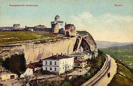 Inkerman Cave Monastery around 1910.
 Inkerman orthodox men's cave monastery of St.Clement in 2009.
See also
External links
- (English) (Russian) (Ukrainian) Official Sevastopol city website
- (Russian) Inkerman
- (Russian) Panoramas of Inkerman
- ↑ Russian Federal State Statistics Service (2014). "Таблица 1.3. Численность населения Крымского федерального округа, городских округов, муниципальных районов, городских и сельских поселений" [Table 1.3. Population of Crimean Federal District, Its Urban Okrugs, Municipal Districts, Urban and Rural Settlements]. Федеральное статистическое наблюдение «Перепись населения в Крымском федеральном округе». ("Population Census in Crimean Federal District" Federal Statistical Examination) (in Russian). Federal State Statistics Service. Retrieved January 4, 2016.