Inn (river)
| Inn | |
|---|---|
 Map highlighting the Inn | |
| Other name(s) | Romansh: En |
| Country | Switzerland, Italy, Austria, Germany |
| Basin | |
| Main source |
Swiss Alps (Lägh dal Lunghin) 2,484 m (8,150 ft) 46°25′00″N 9°40′35″E / 46.41673°N 9.67645°E |
| River mouth |
Danube (Passau) 291 m (955 ft) 48°34′25″N 13°28′38″E / 48.57353°N 13.47713°ECoordinates: 48°34′25″N 13°28′38″E / 48.57353°N 13.47713°E |
| Basin size | 26,130 km2 (10,090 sq mi) |
| Physical characteristics | |
| Length | 517 km (321 mi) |
| Discharge |
|
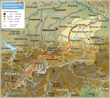
The Inn (Latin: Aenus;[1] Romansh: En) is a river in Switzerland, Austria and Germany. It is a right tributary of the Danube and is 517 kilometres (321 mi) long. The highest point of its drainage basin is the summit of Piz Bernina, at 4,049 metres (13,284 ft). The Engadine, the valley of the En, is the only Swiss valley from which its waters ends in the Black Sea (via the Danube).
Geography
The source is located in the Swiss Alps, west of St. Moritz in the Engadine region, which is named after the river (Romansh Engiadina; Latin vallis Eniatina). Shortly after it leaves its source, the Inn flows through the largest lakes on its course, Lake Sils and Lake Silvaplana. It runs north-eastwards, entering Austria, and from Landeck eastwards through the Austrian state of Tyrol and its capital, Innsbruck (bridge over the Inn), and crosses the border into Bavaria near Kufstein.
On Bavarian territory the river runs northwards and passes Rosenheim, Wasserburg am Inn, and Waldkraiburg; then it turns east, runs through Mühldorf and Neuötting and is enlarged by two major tributaries, the Alz and the Salzach.
From here to the Danube, it forms the border between Germany (Bavaria) and Austria (Upper Austria). Towns on this last section of the river are Simbach on Inn, Braunau am Inn and Schärding. There are numerous small towns, including Braunau am Inn in Austria, and Marktl am Inn in Bavaria, Germany.
In Passau the Inn finally enters the Danube (as does the Ilz river there). Although the Inn has a greater average flow than the Danube when they converge in Passau, and its watershed contains the Piz Bernina also the highest point in the Danube watershed, the Inn is considered a tributary of the Danube, which has a greater length, drains a larger surface area, and has a more consistent flow. The Inn is the only river originating in Switzerland that ends in the Black Sea (via the Danube).
Tributaries

- Right tributaries (in downstream order): Flaz, Spöl, Clemgia, Faggenbach, Pitzbach, Ötztaler Ache, Melach, Sill, Ziller, Alpbach, Wildschönauer Ache, Brixentaler Ache, Weißache, Kaiserbach, Rohrdorfer Ache, Sims, Murn, Alz, Salzach, Enknach, Mattig, Ach, Antiesen, Pram
- Left tributaries (in downstream order): Beverin, Schergenbach, Sanna, Gurglbach, Brandenberger Ache, Kieferbach, Auerbach, Kirchbach, Mangfall, Attel, Isen, Rott
- Hartberg (river)
Flow
Average monthly flow (m³/s) of the Inn in Passau
Years 1921/2006[2]

2013 flood
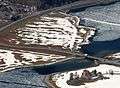
On June 3, 2013, the discharge of the Inn in Passau reached 6,820 m3/s (241,000 cu ft/s)[2] and the water levels reached 12.85 m (42.2 ft), the highest recorded historic flood level since 1501.[3] The historic centre of Passau, where the Danube, Inn and Ilz converge, was flooded severely.
2013 flood image gallery
.jpg) The "Old City" (Die Altstadt) of Passau. In front the Danube River
The "Old City" (Die Altstadt) of Passau. In front the Danube River Water level marks on the Town Hall in Passau
Hydroelectric power plants
Currently, there are 23 hydroelectric power plants on the Inn. 17 of them are operated by Verbund AG.[4] The power plants are listed beginning at the headwaters:
| Dam | Nameplate capacity (MW) | Annual generation (Mio. kwh) |
|---|---|---|
| Islas[5] | 4.3 | 17 |
| Ova Spin[6] | 50 | 100 |
| Pradella[7] | 288 | 1,000 |
| Imst[8] | 89 | 550 |
| Kirchbichl[9] | 19.3 | 131 |
| Langkampfen[10] | 31.5 | 169 |
| Oberaudorf-Ebbs | 60 | 268 |
| Nussdorf | 48 | 245.8 |
| Rosenheim | 35 | 179.5 |
| Feldkirchen | 38 | 204 |
| Wasserburg | 29 | 165.7 |
| Teufelsbruck | 25 | 150.4 |
| Gars | 30 | 169.2 |
| Jettenbach | 6 | 30.2 |
| Töging | 85 | 564.6 |
| Neuötting | 26 | 159.4 |
| Perach | 19 | 128.4 |
| Stammham | 23 | 136.4 |
| Braunau-Simbach | 100 | 550 |
| Ering-Frauenstein | 72 | 434 |
| Egglfing-Obernberg | 84 | 485 |
| Schärding-Neuhaus | 96 | 541.8 |
| Passau-Ingling | 86 | 504.7 |
Image gallery
 Bridge over the Inn at Silvaplana, Upper Engadine (CH)
.jpg) Inn between Susch and Lavin, Lower Engadine
Inn between Susch and Lavin, Lower Engadine The Inn in Scuol, Lower Engadine (CH)
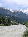
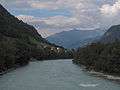 between Stein and Pfunds in the Inn Valley (A)
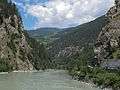 between Aussengufer and Fliess in the Inn Valley (A)
 between Nesselgarten and Prutz in the Inn Valley (A)
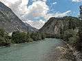 near Landeck (A)
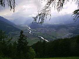
 The Inn in Innsbruck (A)
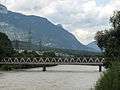 Rotholz, bridge across the Inn
References
- ↑ Richard J.A. Talbert, ed. (2000). Barrington Atlas of the Greek and Roman World: Map-By-Map Directory. I. Princeton, NJ and Oxford, UK: Princeton University Press. p. 171. ISBN 0691049459.
- 1 2 "Statistik Passau Ingling / Inn" (in German). www.hnd.bayern.de. Retrieved 2016-04-05.
- ↑ "Central Europe Hit by Rains, Floods and Landslides: AIR Analysis". www.insurancejournal.com. 2013-04-06. Retrieved 2016-04-05.
- ↑ "VERBUND on the Inn". Verbund. Retrieved 2016-01-18.
- ↑ "Elektrizitäts-Produktion" (in German). www.stmoritz-energie.ch. Retrieved 2016-01-18.
- ↑ "Zentrale Ova Spin" (in German). Engadiner Kraftwerke. Retrieved 2016-01-18.
- ↑ "Zentrale Pradella" (in German). Engadiner Kraftwerke. Retrieved 2016-01-18.
- ↑ "Kraftwerk Imst" (in German). Tiwag. Retrieved 2016-01-18.
- ↑ "Kraftwerk Kirchbichl" (in German). Tiwag. Retrieved 2016-01-18.
- ↑ "Kraftwerk Langkampfen" (in German). Tiwag. Retrieved 2016-01-18.
External links
| Wikimedia Commons has media related to Inn River. |
- Inn (district and river) in Romansh, German, French and Italian in the online Historical Dictionary of Switzerland.
| Countries |  | |
|---|---|---|
| Cities | ||
| Tributaries | ||
| See also | ||