Rosenheim
| Rosenheim | ||
|---|---|---|
|
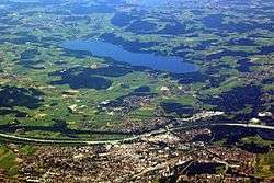
2010 aerial photo of Rosenheim and Simssee. | ||
| ||
 Rosenheim | ||
| Coordinates: 47°51′0″N 12°8′0″E / 47.85000°N 12.13333°ECoordinates: 47°51′0″N 12°8′0″E / 47.85000°N 12.13333°E | ||
| Country | Germany | |
| State | Bavaria | |
| Admin. region | Oberbayern | |
| District | urban district | |
| Government | ||
| • Mayor | Gabriele Bauer[1] (CSU) | |
| Area | ||
| • Total | 37.22 km2 (14.37 sq mi) | |
| Population (2015-12-31)[2] | ||
| • Total | 61,844 | |
| • Density | 1,700/km2 (4,300/sq mi) | |
| Time zone | CET/CEST (UTC+1/+2) | |
| Postal codes | 83001-83028 | |
| Dialling codes | 08031 | |
| Vehicle registration | RO | |
| Website | rosenheim.de | |

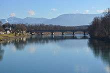
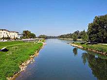
The independent city of Rosenheim (Central Bavarian: Rousnam) is located in the centre of the district of Rosenheim (Upper Bavaria), and is also the seat of administration of this region. It is located on the west bank of the Inn at the confluence of the rivers Inn and Mangfall, in the Bavarian Alpine Foreland. It is the third largest city in Upper Bavaria with over 61,000 inhabitants and one of 23 administrative centres in Bavaria. Rosenheim is therefore the economic centre and the busiest place in the region.
Geography
The population of the town proper is approximately 60,000 inhabitants with up to 125,000 in the surrounding area. Rosenheim is situated in the Upper-Bavarian Alpine Foothills, 450 metres (1,476 feet) above sea level and covers an area of 37.52 square kilometres (14.49 sq mi). The capital of Bavaria, Munich, is 52 kilometres (32 miles) away in North-West direction from Rosenheim. Rosenheim station is at the junction of the Munich–Rosenheim, the Rosenheim–Salzburg and the Munich–Innsbruck lines.
The landscape around Rosenheim was formed during the last ice age from the advancement of the Inn Valley Glacier and later from the Rosenheim lake. The lake existed about 10,000 years ago, covering the whole Inn valley as far as Wasserburg am Inn, about 25 km north of Rosenheim.
Even today in many places around the city the former shoreline can be recognised where the former flat lake bed changes suddenly into relatively steep embankment.
Neighbouring communities
| Großkarolinenfeld | Schechen | ||
| Kolbermoor | |
Stephanskirchen | |
| |||
| | |||
| Raubling | Rohrdorf |
City neighborhoods
|
Southbound on the Railway Line:
|
Northbound on the Railway Line:
|
History
Rosenheim's development can be traced from its location on intersecting major trade routes. Even in early times, the city's intersecting traffic stimulated its development as a market town. It subsequently evolved from a market to a salt trade and then railway town to today's wood and college town.
Pons Aeni
Crucial to the establishment of Rosenheim were the Inn and the corresponding Inntal. The Romans arrived in the year 15 BC under the leadership of Drusus and Tiberius. They founded to the East right of the Inn the province Noricum and to the west of the Inn Rhaetia. The colonizers built a road through the burner to Castra Regina, and one running east-west road from Iuvavum to Augusta Vindelicum. The intersection of these two enormously important trade routes were protected by a military station whose name was "Pons Aeni". Less frequently used terms were "Ponte Aoni", "Ad enum" or "stations Enensis". The Romano Celtic settlement existed for some 500 years with that name. Pons was between Aeni Isinisca (Aying) and Bedaium, as shown on the Roman road map Tabula Peutingeriana from the 4th century. The name "Pons Aeni" can still be recognised in local place names, "Pfunzen" in the name of the district "Langenpfunzen" and "Leonhardspfunzen".[3]

Origin of the city name
The origin of the city's name is not completely clear. First mentioned in 1234, Rosenheim castle is on the eastern bank of the Inn, on today's castle hill, overlooking a new bridge over the Inn. Perhaps the name comes from the Rosenheim Rose emblem of the Wasserburger Earl Hall, who built the castle. Another theory is that originally the name Ross was derived from the Rössern steeds that were used in medieval times to pull the river transport vessels, and for which there were large stables in Rosenheim. Still in use today the street names Am Esbaum (the tree on which the horses were grazing) or Am Roßacker are possible indications.
Another theory suggests that there could be a kindred word Roas, Roze oder Ried, that used to mean swamp and peat bogs, which are still to be found around Rosenheim - evident also by the name of the neighboring town of Rosenheim Kolbermoor. An example of the old names, the nearby village of Riedering. Maybe the name is also derived from Rosenheim personal names Roso/Hrodo. The most beautiful word for word theory is that formerly 'Rose' used to mean a beautiful girl. It was well known among the Inn boatmen that there were many beauties to admire in this city! The sailors of the town liked to control what was called "home of the Rose" - in other words Rosenheim.
Development of Rosenheim
At about the time the first mention of Rosenheim castle in 1234, a settlement of boatmen developed on the western shore. The area around the Inn Bridge was not developed for a long time due to marshy soil at the proximity of the mouth of the Mangfall, so the settlement was located several hundred meters away. The centre of Rosenheim is therefore not directly on the riverside.

Market Rosenheim
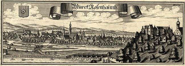
The town quickly grew in importance as a hub for all types of goods that were transported to the Inn (livestock, grain, silk, arms, salt), and received the 1328 Markets status. The Rosenheim ship masters made Rosenheim very wealthy during this era through the transport of goods, due to the location between Hall in Tirol the Inn and onwards to the Danube down to Vienna and Budapest. Until about 1600 the settlement had grown into one of the largest and most important markets in Bavaria, even though City status was only attained in 1864 from the Bavarian King Ludwig II.
Rosenheim experienced economic decline during the 17th century in the wake of the decline of Inn Shipping Company and the consequences of the Thirty Years' War. There were also a plague epidemic (1634) and a market fire (1641).

In the 19th century Rosenheim developed as an economic centre in the Southeast of Bavaria due to brine. In 1810 an early type of wooden pipeline brought brine from the salt mines in the area Reichenhall and Traunstein to Rosenheim. Boiling the salt made Rosenheim the centre of Bavarian salt production until 1958.
Expansion of the railways brought early connection to the railway. In 1858 Rosenheim station was inaugurated, which however would soon be too small and prove a hindrance for further urban development, in 1876 the station moved to its present site. The old railway line was the straight through road (now the Town Hall and Prince Regent Street, main Rosenheimer transport axis, from the northwest to the southeast of the city), the roundhouse of the first station now serves as an exhibition center, the old station is directly opposite the 1878 City Hall - and is used in the ZDF-evening series "Die Rosenheim-Cops" as the backdrop of the police headquarters.
The economic boom of the late 19th and early 20th century made the Gründerzeit - and Art Nouveau (and its regional characteristics, the Swiss chalet style) the most important architectural style, which now determines the townscape. It was built in the emerging civic centre to the present Town Hall and the Lutheran Church of the Redeemer in Rosenheim for rare Gothic Revival-style brick for the widening Evangelical Lutheran Church.
At the beginning of the 20th century,Rosenheim had nine breweries which are still preserved in the names of some restaurants (Duschl-, Hof-, Mail-, Pernloher-, Stern-, Weißbräu). The only survivors being "Auerbräu" and "Flötzinger Bräu" and supply, among others, the "Märzenbier" for the "Rosenheimer Herbstfest", as well as the Bierbichler Weißbräu.
Rosenheim in the Nazi era
The number of Jews living in Rosenheim was high compared to other Bavarian cities. However, at the start of the 20th century, the Jewish community consisted of about 50 people. The request to the city council for establishment of a separate Jewish religious association, with reference to the Bavarian-Jewish legislation, was refused, so the Rosenheim Jews remained attached to the state capital, where their dead also had to be buried. Even the funeral of the First World War fallen son of a Jewish merchant based in Rosenheim at the city cemetery was refused and was "the biggest disappointment and the bitterest pain" for the father.
With the creation of the first local Nazi group outside of Munich in 1920, the Rosenheim Jews saw increasing hostility. Centre of hate campaigns was the Rosenheim School. A scandal occurred in June 1920, after a reader accused the writer of a letter titled "Rosenheimer Jews" in the local press, who wanted to repeal the provisions of the Versailles Treaty and held military exercises at the Rosenheim School. Seven members of the high school and a member of the "Chiemgau" then raided a villa inhabited by Jews in the Herbststrasse. The college of the city of Rosenheim, on 29 July 1920 came to the conclusion that
… es sei bedauerlich, dass die Bewegung zur Bekämpfung eines volksausbeuterischen Judentums […], die in ihrem Wesen gewiß berechtigt sei, durch solche Auswüchse in Mißkredit komme.
"... it was regrettable that the people's movement to fight exploitative Jews[...], which certainly was justified in its nature, has been discredited." Protests of the Bavarian Jewish Central Association were unsuccessful, only an unmistakable message of the Bavarian Interior Ministry September 1920 was able to maintain peace.
On 1 April 1933, shortly after the Nazi seizure of power, guards were set up in front of Jewish shops, warning against buying in these stores, but to desist assault and criminal damage. A large proportion of the population ignored these calls. The shops were therefore still frequented, much to the annoyance of Nazi activists who acted with the backing of then-Mayor Gmelch. Despite the support of the population, six of the eleven Jewish business owners gave up their businesses by 1937.
The assassination of German diplomat vom Rath by the Jew Herschel Grynszpan on 7 November 1938 in Paris, was taken as a final opportunity to strike against the Jews. The SA came on 10 November at 3–4 o'clock in the morning with 8 to 10 men to the last two Jewish shops and destroyed their inventory and merchandise.
The fate of many Rosenheim Jews is documented. Those who could, emigrated, mostly in the United States. However, many failed entry and exit applications, and many died in concentration camps.[4]
Bombing during the Second World War
From the beginning of bombing raids on German cities in the spring of 1942, Rosenheim was not spared. In November 1943 there were shelters for only 650 people for a city population of approximately 22,000. However, by February 1944 shelters had been built for about 6400 people and in conjunction with other shelters a total of 10,525 people could be protected.
During 14 bomb attacks, 201 people were killed and 179 injured. The focus of the air attacks was the railway station and the railway tracks, as Rosenheim was an important transportation hub between Munich, Salzburg and Innsbruck. The neighbouring communities of Ziegelberg, Stephanskirchen, Westerndorf St. Peter and Oberpfaffenhofen were also hit. The first air attack was on 20 October 1944 at lunch time from 12:47 to 13:17 o'clock with over a hundred aircraft dropping 1,000 bombs, leaving 27 dead and 59 wounded. The heaviest air raid took place on 18 April 1945. From 14:40 to 14:55 around 200 to 1300 aircraft dropped bombs in the area around the station, resulting in 53 dead and 36 injured, in addition, this attack also made 800 people homeless. The station building was almost completely destroyed and railway tracks were destroyed over a length of 20 kilometers. The last air attacks were made on 19 and 21 April 1945. During the war the majority of at least 173 unexploded bombs were recovered. In 1964, the Oberbayerische Volksblatt reported that the approximate location of 38 undiscovered unexploded ordnance was known.[4]
History timeline
|
Population growth

The population growth rate in the last 10 years was about 3 Percent.
|
|
¹ Census results
Coat of arms
The emblem of the city of Rosenheim shows a white rose on a red background. This may indicate the former arms of Wasserburg am Inn have returned, because Wasserburg ruled Rosenheim until 1247. The oldest known seal of the city of Rosenheim was built in 1374 and already shows the rose, which has not changed since. The only exception is a picture by Philipp Apian, which was painted around the year 1568 and shows a border around the rose.[12]
There is also a Logo for the city of Rosenheim, containing the same rose which is present on the coat of arms.
Culture and Sights

Theater
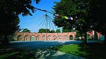
The Culture and Congress Centre Rosenheim (KU'KO) was built on the site of the brine works, demolished in 1967. Inaugurated on October 2, 1982 as the town hall, now the Culture and Congress Centre Rosenheim has evolved over the years into a national event centre. Today in the 3000-square-foot multipurpose building approximately 400 events are held annually.
Museums
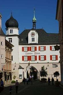
Since 1885, the Mittertor has housed the Municipal Museum with a large collection (about 5000 exhibits) of the cultural history of the town and district of Rosenheim, from the prehistory and early history and Roman times to the recent city history in the 20th century. It is one of the most important regional history collections in South East Upper Bavaria.
The Inn Museum houses the hydraulic engineering and marine technology collection of the Rosenheim Water Management Office and is located in the historic river master's Bruckbaustadel at the Inn Bridge. With many original objects, the museum displays the Inn Shipping Company, the source of Rosenheim's prosperity in the Middle Ages, in the past centuries. In addition, the museum provides facts about the river landscape and river engineering, geology, settlement history, marine engineering, bridge design and the development of waterways.
The Wood technology Museum was established in 1990 in the listed Ellmaierhaus. It is housed on the first floor, which is accessed via the so-called Jacob's ladder. At more than 400 square meters of exhibition space displays this unique museum, which is closely related to the timber town of Rosenheim and its training centres for wood occupations, wood as a raw material, its importance and processing past and present. The exhibition shows not only the end products, but also their production and the necessary tools. Regular special exhibitions complete the offer of the Wood technology Museum.
The Municipal Gallery of 1935-1937 was built by German Bestelmeyer. Every year, six art exhibitions are held here. In addition to contemporary art, also exhibitions of works from the 19th and 20th century are held. A thematic focus is the art from the region and the Munich School.
The Lokschuppen is an internationally renowned exhibition centre with annually changing exhibitions in the former railways round house.
The brine pump house is one of the few monuments in the city which recall time from 1810 to 1958 of Rosenheim's brine industry.[13] As part of the National Exposition salt makes history, the city renovated the historic, listed building and set up an exhibition room about Rosenheim's brine history. Admission is only possible with city guides or by agreement with the Metropolitan Museum.
The Klepper museum houses various exhibits, on the one hand the history of the Klepper-Boote show coats and tents. On the other hand, it is also dedicated to the development of the company Klepper, who was once the biggest employer in the city.
Buildings
See also list of monuments in Rosenheim, only in German

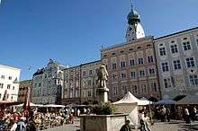
The Mittertor (the sole survivor of five market gates) was the eastern gate of the market before 1350, which was then protected with a double ditch. Since the 15th century, it separated the interior from the exterior of the market served as a customs office. Until the 19th century it also contained several municipal facilities such as the town clerk's office. After the great fire in 1641 the city of Rosenheim onion dome was built and later extended into a long building. At its core is the Mittertor the oldest building in town. On the façade to the side of the square is the emblem of Louis Rosenheim, with the white rose against a red background. The Bavarian crest can also be seen here.
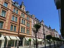
Munich streets Münchener Strasse follows the Gillitzerblocks, also called "small pedestrian zone." Immediately apparent are the magnificently restored "Gründerzeitfassaden". The name Gillitzerblocks come from their builder Thomas Gillitzer. At the end of the 19th century he obtained a relatively large area of land, for its day, and built 15 houses, including the Hotel Deutscher Kaiser. Since the 1960s, the once self-contained Gründerzeit ensemble has altered with new construction and renovations. Only the façades in Münchener Strasse have been preserved and restored to the original.
The Quest-Kunstmühle (art mill) was built from 1855 to 1916 in several phases as industrial complexes. It was renovated in the 1990s and now serves as a restaurant and office space. The Quest-Kunstmühle Power station is located on the Mangfallkanal.
The Art Mill houses the exhibition halls of the Rosenheim arts club. The approximately 200 square metres (2,153 sq ft) upper floor of the former art mill holds exhibitions of contemporary artists, exchange exhibitions with other art associations and activities accompanying the exhibition.
The Rosenheim ballroom was built in the former Rosenheim Hofbräus buildings. The hall with ballroom and vaulted cellar was built in 1878. It was renovated in 1994 and since 2001 has been used as an event space, with its many possible uses of the centre of the eastern town of Rosenheim.
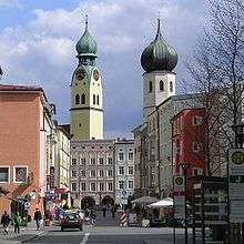
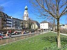
The town's landmark is the gothic spire (65 m (213 ft)) of the parish church St. Nikolaus (1,450 m (4,757 ft)) with its baroque onion dome (1,641 m (5,384 ft)).
| Name | Sculptor |
|---|---|
| Wasserrad | Josef Hamberger |
| Stehende | Rolf Märkl |
| Liegende | Marianne Lüdicke |
| Mensch und Pferd | Prof. Heinrich Kirchner |
| Norne | Louise Stomps |
| Passantengruppe | Erika Maria Lankes |
| Stele | Alfred Regnat |
Parks
The Kunstwiese shows three-dimensional contemporary art works by artists from Rosenheim all year round.
The Riedergarten was created in 1729 as a private herb garden by Rosenheim pharmacist Johann Rieder. It was sold to the city in 1925 by physician Dr. Herman Rieder for use as a summer garden. In 2002 the garden was redesigned by the opening up of a previously culverted stream, adding a modern character.
Since 1987 the Salingarten, in front of the Culture and Congress Centre Ku'Ko, has been used as a sculpture garden. Large sculptures by important sculptors from Rosenheim and environment can be seen here.
International relations
Famous people
_2008.11.24_009.jpg)
- Nicholas McCarthy (born 1974), English musician
- Siegfried Fischbacher
- Hermann Göring (1893-1946), leading German politician of the NSDAP, war criminal
- George Dzundza (born 1945), actor
- Nadine Samonte (born 1988), actress
- Hans-Ulrich Rudel
- Tobias Schweinsteiger (born 1982), brother of Bastian Schweinsteiger, former football player
- Edmund Stoiber, (born 1941), politician and jurist, former Minister President of Bavaria (CSU)
- Mark Benecke (born 1970), biologist
- Jupp Kapellmann (born 1949), former German footballer
- Lars Bender (born 1989), footballer
- Sven Bender (born 1989), footballer
- Martin Tomczyk (born 1981), auto racing driver
- Annemarie Schneider
- Ray Manzarek (1939-2013), American musician, member of The Doors

Famous neighbour cities
Twin towns – Sister cities
| Rosenheim is twinned with: | ||
| | Lazise in Italian Lake Garda, since 1974 | |
| | Briançon (France), since 1979 | |
| | Greiz (Thüringen), since 1991 | |
| | Ichikawa (Japan), since 2004 | |
| Beersheba (Israel), since 1983 | ||
| Rosenheim is friendly with: | ||
| | Kufstein (Austria) | |
See also
References
- ↑ Oberbürgermeisterin Gabriele Bauer Stadt Rosenheim (2014)
- ↑ "Fortschreibung des Bevölkerungsstandes". Bayerisches Landesamt für Statistik und Datenverarbeitung (in German). June 2016.
- ↑ Stefan Trux, Franz Hilger: Rosenheim – Tor zum Inntal. S. 12.
- 1 2 Rosenheim im Dritten Reich; Beiträge zur Stadtgeschichte, herausgegeben vom Kulturamt der Stadt Rosenheim 1989
- ↑ Joseph von Klöckel: Rosenheim mit seiner Heilquelle und Umgegend im Jahre 1815 beschrieben, 1. Bd.: Rosenheim mit seiner Heilquelle, München 1815, hier: S. 19
- 1 2 Stempfle: Chronik der Stadt Rosenheim 1860–1890, in: Das bayerische Inn-Oberland 43 (1981), S. 73–148
- ↑ Das bayerische Oberland am Inn 6 (1907), S. 69
- ↑ Brockhaus Kleines Konversations-Lexikon. Band 2. 5. Auflage. Leipzig 1911, S. 557.
- ↑ Sachkartei im Stadtarchiv Rosenheim
- ↑ Wendelstein Nr. 64 (1950)
- ↑ Oberbayerisches Volksblatt 26. Juli 1946
- ↑ Wappenverzeichnis: http://www.ngw.nl/int/dld/r/rosenhei.htm
- ↑ Ludwig Gassner: Rosenheim und dessen Umgebung. Für Fremde und Einheimische unter besonderer Berücksichtigung des Heilbades Rosenheim. Rosenheim 1865 (online).
External links
- Official Site (German)
- Fachhochschule Rosenheim (German)
-
 Chisholm, Hugh, ed. (1911). "Rosenheim". Encyclopædia Britannica (11th ed.). Cambridge University Press.