Interstate 194 (Michigan)
| ||||
|---|---|---|---|---|
|
Sojourner Truth Downtown Parkway The Penetrator | ||||
|
I-194 highlighted in red | ||||
| Route information | ||||
| Auxiliary route of I-94 | ||||
| Maintained by MDOT | ||||
| Length: | 3.374 mi[1] (5.430 km) | |||
| Existed: | 1961[2][3] – present | |||
| Major junctions | ||||
| South end: |
| |||
|
| ||||
| North end: |
| |||
| Location | ||||
| Counties: | Calhoun | |||
| Highway system | ||||
| ||||

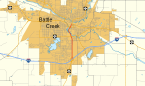
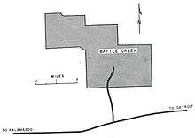
Interstate 194 (I-194) is a 3.4-mile-long (5.5 km), north–south freeway between downtown Battle Creek and I-94 in the southern portion of the city. The highway has been designated the Sojourner Truth Downtown Parkway by the state after the abolitionist Sojourner Truth, who was active in the Battle Creek area. Locals refer to the freeway by its semi-official nickname,"The Penetrator". I-194 is the only three-digit spur or loop route off I-94 in the state of Michigan and runs concurrently throughout its length with M-66, which continues both north and south from the termini of I-194. The freeway was initially opened in 1961 and completed in its current form in 1966. The highway was named in 1976 for Truth in honor of her local connections to the area.
Route description
Part of the much longer highway, I-194 starts when M-66 widens out to a full freeway just south of I-94 near Beckley Road. The start of I-194 is marked by the full cloverleaf interchange. It is numbered as exit 98 along I-94 and exit 1 using I-194's mileage along the I-194/M-66 freeway. The roadway crosses Minges Creek north of the I-94 interchange. To the west of the freeway are residential subdivisions; the eastern side is marked by gently-rolling, wooded terrain.[4] This section of I-194 carries 26,300 vehicles on an average day according to annual average daily traffic surveys done by the Michigan Department of Transportation (MDOT) in 2007.[5] Of these vehicles, 1,200 trucks were included in the totals.[6]

After crossing Golden Avenue, I-194 curves to the northwest to meet the M-96 (Columbia Avenue) interchange. The freeway runs underneath the Columbia Avenue overpass before running parallel to the west bank of the Kalamazoo River. The freeway crosses the river at the southern end of Lower Mill Pond. Curving back around to the northeast, I-194 meets Business Loop I-94 (BL I-94, Dickman Road).[4] Here the AADT counts average 24,400 vehicles a day.[5] The freeway ends at an at-grade intersection with Hamblin Avenue, and continuing north of the intersection, the highway becomes just M-66. BL I-94 runs east of the freeway end on Hamblin Avenue to connect to Michigan Avenue.[4] All of I-194 is listed on the National Highway System, a system of strategically important highways,[7] and it is concurrent with M-66 for the length of the freeway.[8]
History
From its initial opening in 1961[2][3] until 1964,[9] I-194 also carried the BL I-94 and M-78 designations. BL I-94 was rerouted in Battle Creek to Martin Luther King Drive and M-78 in 1964, and M-78 was replaced by M-66 in 1965.[10] The last change to the I-194 routing was the extension of the northern end of the freeway from Columbia Avenue to Michigan Avenue in 1966.[11] At the time, MDOT's predecessor, the Michigan State Highway Department, called all auxiliary Interstate Highways "Penetrator" when planning the freeway network in the state;[12] a name which stuck to I-194.[13]
Born Isabella Baumfree in 1797, Sojourner Truth settled in the Battle Creek area in the 1840s. She travelled through the Midwest and New England speaking against slavery and for women's rights. She lived in the area until her death in 1883. Her connection to the state of Michigan was honored by the state American Revolution Bicentennial Commission in 1976 which urged the Michigan Legislature to name a highway in her honor. Public Act 93 of 1976 named all of M-66 in Calhoun County as the Sojourner Truth Memorial Highway. The highway was dedicated to her on May 21, 1976.[14]
The Cereal City Development Corporation (CCDC) asked the Legislature to amend the memorial designation in 1993. They felt the highway was better known to locals as The Penetrator, and they wished to restore emphasis to Truth, they asked for the "Sojourner Truth Downtown Parkway" name to be applied to "M-66 between Interstate 94 and Hamblin".[14] The Legislature passed Public Act 208 of 1993 to affect the change, restoring "the link between Sojourner Truth and the City of Battle Creek, which was once the center of abolitionist sentiment in the state."[14]
Exit list
The entire highway is in Battle Creek, Calhoun County.
| mi[1] | km | Exit[8] | Destinations | Notes | |
|---|---|---|---|---|---|
| 0.000 | 0.000 | 1 | Signed as exits 1A (east) and 1B (west); I-194 starts concurrent with M-66, I-94 exit 98B; cloverleaf interchange | ||
| 2.048 | 3.296 | 2 | |||
| 3.161 | 5.087 | 3 | |||
| 3.374 | 5.430 | Hamblin Avenue | At-grade intersection; freeway ends and highway continues as M-66 | ||
1.000 mi = 1.609 km; 1.000 km = 0.621 mi
| |||||
See also
 Michigan Highways portal
References
- 1 2 Michigan Department of Transportation & Michigan Center for Shared Solutions and Technology Partnerships (2009). MDOT Physical Reference Finder Application (Map). Michigan Department of Transportation. Retrieved April 9, 2010.
- 1 2 Michigan State Highway Department (1960). Official Highway Map (Map). Scale not given. Lansing: Michigan State Highway Department. Battle Creek inset. OCLC 12701120, 81552576. (Includes all changes through July 1, 1960)
- 1 2 Michigan State Highway Department (1961). Official Highway Map (Map). Scale not given. Lansing: Michigan State Highway Department. Battle Creek inset. OCLC 12701120, 51857665. (Includes all changes through July 1, 1961)
- 1 2 3 Google (November 14, 2008). "Battle Creek, MI" (Map). Google Maps. Google. Retrieved November 14, 2008.
- 1 2 Michigan Department of Transportation (2007). Battle Creek AADT Map (PDF) (Map). Lansing: Michigan Department of Transportation. Retrieved October 7, 2008.
- ↑ Michigan Department of Transportation (2007). Commercial Battle Creek AADT Map (PDF) (Map). Lansing: Michigan Department of Transportation. Retrieved October 7, 2008.
- ↑ Michigan Department of Transportation (April 23, 2006). National Highway System, Michigan (PDF) (Map). Lansing: Michigan Department of Transportation. Retrieved October 7, 2008.
- 1 2 Michigan Department of Transportation (2008). Michigan: Official Department of Transportation Map (Map). c. 1:221,760. Lansing: Michigan Department of Transportation. Battle Creek inset. OCLC 42778335.
- ↑ Michigan State Highway Department (1964). Official Highway Map (Map). Scale not given. Lansing: Michigan State Highway Department. Battle Creek inset. OCLC 12701120, 81213707.
- ↑ Michigan State Highway Department (1965). Official Highway Map (Map). Scale not given. Lansing: Michigan State Highway Department. Battle Creek inset. OCLC 12701120.
- ↑ Michigan Department of State Highways (1966). Official Highway Map (Map). Scale not given. Lansing: Michigan Department of State Highways. Battle Creek inset. OCLC 12701120.
- ↑ Richard, Tim (April 3, 1986). "I-275: The Interstate that Isn't". Observer. Livonia, MI. OCLC 22646576.
- ↑ Vander Meer, John J. (March 18, 2002). "Penetrator To Get $1.6M Face-Lift". Battle Creek Enquirer. pp. 1A, 7A. OCLC 33956507.
- 1 2 3 Barnett, LeRoy (2004). A Drive Down Memory Lane: The Named State and Federal Highways of Michigan. Allegan Forest, MI: Priscilla Press. p. 201. ISBN 1-886167-24-9. OCLC 57425393.
External links
- I-194 at Michigan Highways
- I-194 at Michigan Highway Ends
- I-194 at Kurumi.com
- I-194 Michigan at Interstate Guide
1Unsigned | ||