Interstate 283
| ||||
|---|---|---|---|---|
 | ||||
| Route information | ||||
| Auxiliary route of I-83 | ||||
| Maintained by PennDOT | ||||
| Length: | 2.907 mi[1] (4.678 km) | |||
| Existed: | 1972 – present | |||
| Major junctions | ||||
| South end: |
| |||
|
| ||||
| North end: |
| |||
| Location | ||||
| Counties: | Dauphin | |||
| Highway system | ||||
| ||||

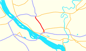
Interstate 283 (I-283), considered State Route 283 (SR 283) by PennDOT, is an auxiliary route of the Interstate Highway System located just east of Harrisburg, Pennsylvania, United States. It travels from the Harrisburg East interchange of I-76 (Pennsylvania Turnpike) north to I-83/US 322 (Capital Beltway) at the Eisenhower Interchange, with a connection to PA 283 near the south end. PA 283 (officially designated as SR 300 because of I-283) continues southeast to Lancaster as a freeway.
Route description

I-283 begins at the Harrisburg East interchange of I-76 (Pennsylvania Turnpike) in Lower Swatara Township, Dauphin County. Past the interchange tollbooth, the road continues north as a four-lane freeway and immediately reaches a cloverleaf interchange with the PA 283 freeway that also has access to PA 230 via Eisenhower Boulevard. I-283 continues north-northwest past business parks before entering areas of farms and woods, crossing into Swatara Township. The road enters commercial areas as it comes to a diamond interchange with PA 441. After that exit, the road continues northwest before turning north and passing an industrial park. I-283 comes to an end at the Eisenhower Interchange with I-83/US 322 (Capital Beltway), at which point the freeway continues north as part of I-83/US 322.[2][3]
Exit list
The entire route is in Dauphin County.
| Location | mi[1] | km | Old exit [4] | New exit [4] | Destinations | Notes | |
|---|---|---|---|---|---|---|---|
| Lower Swatara Township | 0.000 | 0.000 | - | - | Southbound exit and northbound entrance; Harrisburg East exit of I-76 / Penna Turnpike, exit 247. | ||
| 0.016 | 0.026 | 2E | 1A | Last free exit southbound | |||
| 0.016 | 0.026 | 2W | 1B | To Eisenhower Boulevard | |||
| Swatara Township | 1.860 | 2.993 | 1 | 2 | |||
| 2.907 | 4.678 | 28 | 3A | I-83 south exit 46, north exit 46A; northbound exit and southbound entrance; Eisenhower Interchange. | |||
| 2.907 | 4.678 | 28 | 3B | I-83 south exit 46, north exit 46A; northbound exit and southbound entrance; Eisenhower Interchange. | |||
| 2.907 | 4.678 | 28 | 3C | Northbound exit and southbound entrance | |||
| 1.000 mi = 1.609 km; 1.000 km = 0.621 mi | |||||||
See also
 U.S. Roads portal
 Pennsylvania portal
References
- 1 2 Bureau of Maintenance and Operations (January 2015). Roadway Management System Straight Line Diagrams (Report) (2015 ed.). Pennsylvania Department of Transportation. Retrieved June 30, 2015.
- Dauphin County (PDF)
- ↑ Google (2010-12-04). "overview of Interstate 283" (Map). Google Maps. Google. Retrieved 2010-12-04.
- ↑ Dauphin County, Pennsylvania Highway Map (PDF) (Map). PennDOT. 2010. Retrieved 2010-11-30.
- 1 2 "Pennsylvania Exit Numbering" (PDF). Pennsylvania Department of Transportation. Retrieved October 2, 2007.