Pennsylvania Route 283
| |||||||
|---|---|---|---|---|---|---|---|
 | |||||||
| Route information | |||||||
| Maintained by PennDOT | |||||||
| Length: | 29.112 mi[1] (46.851 km) | ||||||
| Existed: | 1967 – present | ||||||
| Major junctions | |||||||
| West end: | South Eisenhower Boulevard in Highspire | ||||||
|
SR 3032 near Harrisburg | |||||||
| East end: |
| ||||||
| Location | |||||||
| Counties: | Dauphin, Lancaster | ||||||
| Highway system | |||||||
| |||||||

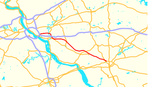
Pennsylvania Route 283 (PA Route 283 or PA 283, officially State Route 300 or SR 300 due to the presence of Interstate 283) is a 29-mile-long (47 km) state highway in the U.S. state of Pennsylvania. It connects Harrisburg to Lancaster as a freeway, paralleling the old U.S. Route 230 (now partly Pennsylvania Route 230). The number was assigned based on the proximity of Interstate 283, but Interstate 283 and PA 283 are not the same roadway; the two intersect at a cloverleaf interchange. Because the road is built to Interstate standards, it is one of the few non-interstate designated highways in Pennsylvania with a posted speed limit of 65 mph (105 km/h) for a considerable distance.
Route description
Dauphin County
PA 283 begins at an intersection with Eisenhower Boulevard (Quadrant Route 3001) near Highspire that connects to Pennsylvania Route 230. PA 283 is one of few Pennsylvania Highways to end at a Quadrant Route. From there, PA 283 intersects Interstate 283 at exit 1 and Interstate 76 (Pennsylvania Turnpike) at exit 247 (Harrisburg East exit) at a cloverleaf interchange. East of I-283 and I-76, PA 283 is a 29-mile-long (47 km) freeway. In Lower Swatara Township, PA 283 has an exit to the Airport Connector freeway (Quadrant Route 3032) that connects to Harrisburg International Airport and Pennsylvania Route 441. This exit has access to Penn State Harrisburg. East of PA 441, PA 283 has an exit to Union Street and Fulling Mill Road which are detours to PA 441. After crossing the Swatara Creek and entering Londonderry Township, PA 283 has an exit to Hummelstown on Vine Street. In Middletown, PA 283 passes over I-76/PA Turnpike and Pennsylvania Route 341. The next exit is an exit that leads to both PA 341 and PA 230.
Lancaster County
The first exit in Lancaster County is an exit to Pennsylvania Route 743. Just east of PA 743, PA 283 passes under Pennsylvania Route 241. In Mount Joy, PA 283 has an exit to Rheems and Elizabethtown. In Rapho Township, PA 283 interchanges with Pennsylvania Route 772. The next exit is split up into two interchanges that lead to the eastern terminus of PA 230 on the Harrisburg Pike. (East of here, PA 283 has a narrow median strip as it is using old Route 230.) In East Hempfield Township, PA 283 interchanges with Spooky Nook Road to Salunga. The next exit is a diamond interchange with the western terminus of Pennsylvania Route 722. In Manheim Township, PA 283 interchanges with Pennsylvania Route 741 and Pennsylvania Route 72. PA 283 terminates (ends) at an interchange with U.S. Route 30 in Lancaster. The first exit is to US 30 west, then the second exit is to Fruitville Pike, and the final exit is to US 30 east.[2][3]
History
PA 283 was first designated in Berks County, Pennsylvania on an approximately one mile road connecting Monocacy Station, Pennsylvania, to Monocacy, Pennsylvania. Between the two towns is the Schuylkill River, and the state owned the bridge which spanned it - one of the many bridges the state had been taking over since the passage of the Sproul Road Bill in 1911. The main road to the south, going through Monocacy Station was then designated as Pennsylvania Route 83 (today it is Pennsylvania Route 724). PA 283 connected 83 to the Benjamin Franklin Highway, US 422, on the north side in Monocacy. The Department of Highways removed the designation in 1946.
In 1961, the designation was revived in the suburbs of Harrisburg, Pennsylvania. It was designated on a section of Eisenhower Boulevard between then US 230 and the interchange at Interstate 83, replacing the retired US 230 Bypass route. This was only temporary designation, however, as an interstate highway connector between the Pennsylvania Turnpike and Interstate 83 was being built. The new interstate was built parallel to Eisenhower Boulevard. When the highway opened in 1969, it was designated Interstate 283, and the PA 283 designation on Eisenhower Boulevard was deleted.[4]
In 1971, construction began on highway connecting Harrisburg to Lancaster. In 1972, the highway was signed as PA 283; however, because state highways cannot be designated the same numbers as Interstate highways, the official, unsigned route number for the highway is SR 300. In 1987, when the Pennsylvania General Assembly passed a law reorganizing the Commonwealth's legislative and traffic routes into the Location Referencing System (LRS), Interstate 283 gained the LRS designation SR 0283, and Pennsylvania Route 283 gained the LRS designation SR 0300.
Exit list
| County | Location | mi[1] | km | Destinations | Notes |
|---|---|---|---|---|---|
| Dauphin | Lower Swatara Township | 0.000 | 0.000 | At-grade intersection, westbound exit, eastbound entrance | |
| 0.178 | 0.286 | I-76 / Penna Turnpike exit 247 (Harrisburg East) | |||
| 0.178 | 0.286 | I-283 exit 1A | |||
| 1.886– 1.896 | 3.035– 3.051 | Penn State Harrisburg | |||
| 2.940 | 4.731 | ||||
| Londonderry Township | 3.927 | 6.320 | Middletown, Hummelstown | Access via Vine Street | |
| 6.857 | 11.035 | West end of PA 341 Truck overlap eastbound | |||
| Lancaster | Mount Joy Township | 11.714 | 18.852 | East end of PA 341 Truck overlap eastbound | |
| 15.086 | 24.279 | Rheems, Elizabethtown | Access via Cloverleaf Road | ||
| Rapho Township | 20.148 | 32.425 | |||
| 21.339 | 34.342 | Esbenshade Road | Eastbound exit, westbound entrance | ||
| 21.996 | 35.399 | Eastern terminus of PA 230, westbound exit, eastbound entrance | |||
| East Hempfield Township | 22.654 | 36.458 | Salunga | Access via Spooky Nook Road | |
| 25.506 | 41.048 | Western terminus of PA 722, continues westbound as State Road | |||
| 27.171 | 43.727 | ||||
| Manheim Township | 27.984 | 45.036 | |||
| Lancaster | 28.610 | 46.043 | Eastbound exit, westbound entrance | ||
| 29.112 | 46.851 | Fruitville Pike | Eastbound exit, westbound entrance | ||
| 29.112 | 46.851 | Eastbound exit, westbound entrance | |||
1.000 mi = 1.609 km; 1.000 km = 0.621 mi
| |||||
See also
 U.S. Roads portal
 Pennsylvania portal
 Lancaster, Pennsylvania portal
References
| Wikimedia Commons has media related to Pennsylvania Route 283. |
- 1 2 Bureau of Maintenance and Operations (January 2015). Roadway Management System Straight Line Diagrams (Report) (2015 ed.). Pennsylvania Department of Transportation. Retrieved June 30, 2015.
- Dauphin County (PDF)
- Lancaster County (PDF)
- ↑ Pennsylvania Tourism and Transportation Map
- ↑ Rand Mcnally 2007 Atlas
- ↑ "Pennsylvania Highways: PA 251-PA 300". PAHighways.com. Retrieved March 2, 2015.