Interstate 840 (North Carolina)
| ||||
|---|---|---|---|---|
|
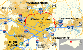
Open segments of I-840 in solid red, future segment in dashed red | ||||
| Route information | ||||
| Maintained by NCDOT | ||||
| Length: | 5.77 mi[1][2][3] (9.29 km) | |||
| Existed: | 2011 – present | |||
| Western segment | ||||
| Length: | 3.56 mi[1] (5.73 km) | |||
| West end: |
| |||
| East end: |
| |||
| Eastern segment | ||||
| Length: | 2.21 mi[2] (3.56 km) | |||
| West end: |
| |||
| East end: |
| |||
| Location | ||||
| Counties: | Guilford | |||
| Highway system | ||||
| ||||

Interstate 840 (I-840) is an Interstate Highway in the U.S. state of North Carolina. It is currently in two sections traversing 5.77 miles (9.29 km) total in Guilford County; when completed, it will form the northern section of the Greensboro Urban Loop.
Route description
I-840 currently exists in two segments that will eventually form the northern bypass around Greensboro.
The western segment, a divided six-lane urban freeway, begins at the interchange of I-40/I-73/US 421 and goes north for 3.56 miles (5.73 km) to Bryan Boulevard, where it terminates. Currently, this segment is signed as "Future" because it does not reconnect to another U.S. Route or Interstate; however, it has been a federally recognized interstate since 2011 despite the current banner. The entire route is in concurrency with I-73.
The eastern segment, a divided four-lane rural freeway, begins at US 70 (Burlington Road) and goes south for 2.21 miles (3.56 km) to the I-40/I-85/I-85 Bus interchange, its eastern terminus. The entire route is in concurrency with I-785. The eastern segment is currently unsigned with plans of it remaining as a hidden designation for I-840 until it connects with the western segment.
Both sections have a maximum speed limit of 65 miles per hour (105 km/h).
History
I-840 first appeared in the early 2000s as a proposed routing for the northern half of the Greensboro Urban Loop. In 2002, the first segment opened between US 70 and I-40/I-85; however, it was unsigned and designated as SR 3269; by 2006, Future I-840 signage was added at the US 70 interchange. In December 2007, a second segment opened along its routing between I-40/US 421 and Bryan Boulevard and was signed as Future I-73/I-840. In 2010, NCDOT submitted its official request, to both the AASHTO and the FHWA, to designate the two existing segments of the northern half of the Greensboro Urban Loop as I-840 and the 15.26-mile (24.56 km) unbuilt portion as Future I-840. AASHTO approved the request on October 29, 2010 followed by FHWA on August 2, 2011.[4] On September 2, 2011, NCDOT certified the route change establishing I-840.[5]
Construction on the northern half of the Greensboro Urban Loop resumed in 2013 with the 3.8-mile (6.1 km) segment, between Bryan Boulevard and Battleground Avenue (US 220), which will be signed as I-840.[6] In late 2014, a 5.5-mile (8.9 km) segment, between US 29 and US 70, also began construction; however, it will be signed as I-785 with I-840 as a hidden designation.[7]
Future

As of 2014, there are four segments of the northern half of the Greensboro Urban Loop to be completed.
- Western Loop (between Bryan Boulevard and US 220) — Construction began on the 3.8-mile (6.1 km) six-lane segment in 2013. At a cost of $123 million, it is expected to be completed in Spring 2018.[8][9][10]
- Western Loop (between US 220 and Lawndale Drive) — This 1.7-mile (2.7 km) six-lane segment is fully funded, at a cost of $54 million.[8][9][11]
- Eastern Loop (between Lawndale Drive and US 29) — This 6.0-mile (9.7 km) six-lane segment is fully funded. At a cost of $162 million, it will have interchanges at Yanceyville Street and North Elm Street.[8][12][13]
- Eastern Loop (between US 29 and US 70) — Construction began on the 5.5-mile (8.9 km) four-lane segment in late 2014. At a cost of $119 million, it will have an interchange at Huffine Mill Road. The project is expected to be completed in Spring 2018.[8][12]
Segments along the western loop will be designated as I-840 upon opening; segments along the eastern loop will have a hidden I-840 designation until it joins with the western loop, fully designating the entire northern half of the Greensboro Urban Loop. Long term plans call for two additional interchanges along I-840: Fleming–Lewiston Road (SR 2136) and Cone Boulevard (SR 2565). Plans for both interchanges have existed since 2004; however, because both are to be constructed after the I-840's completion, there is no current time table or funding for these two projects at this time.[8][14][15]
Exit list
The entire route is in Greensboro, Guilford County.
| mi[1][2] | km | Exit | Destinations | Notes | ||
|---|---|---|---|---|---|---|
| 0.0 | 0.0 | — | Continuation as I-73 and US 421 | |||
| 103A | North end of US 421 overlap; northbound exit left | |||||
| 103B | ||||||
| 1.6 | 2.6 | 104 | West Friendly Avenue | |||
| 3.6 | 5.8 | 3A | Bryan Boulevard – Downtown | Exit 107A (I-73) | ||
| 3B | Exit 107B (I-73); north end of I-73 overlap; eastbound exit, westbound entrance[6] | |||||
| Fleming–Lewiston Road | Future interchange (unfunded)[14] | |||||
| 6 | Future interchange (under construction)[6] | |||||
| 8 | Lawndale Drive | Future interchange (funded)[6][11] | ||||
| 10 | North Elm Street | Future interchanges (funded)[13] | ||||
| Yanceyville Street | ||||||
| 14 | Future interchange (under construction)[7] | |||||
| 16 | Cone Boulevard | Future interchange (unfunded)[7][15] | ||||
| 17 | Huffine Mill Road | Future interchange (under construction)[7] | ||||
| 18.6 | 29.9 | 18 | Eastbound exit and westbound entrance[7] | |||
| 20.8 | 33.5 | 21 | South end of I-785 overlap[7] | |||
| — | Continuation as I-85 | |||||
1.000 mi = 1.609 km; 1.000 km = 0.621 mi
| ||||||
See also
References
- 1 2 3 Google (August 30, 2013). "Interstate 840 - Western Section" (Map). Google Maps. Google. Retrieved August 30, 2013.
- 1 2 3 Google (August 30, 2013). "Interstate 840 - Eastern Section" (Map). Google Maps. Google. Retrieved August 30, 2013.
- ↑ "I-840 Route Change (2011-09-02)" (PDF). North Carolina Department of Transportation. September 2, 2011. Retrieved August 30, 2013.
- ↑ Vaughn, Don W. (October 29, 2010). "Report to the Standing Committee on Highways" (PDF) (Report). Biloxi, MS: American Association of State Highway and Transportation Officials. p. 10. Retrieved November 24, 2014.
- ↑ "US Route Change (2011-09-02)" (PDF). North Carolina Department of Transportation. September 2, 2011. Retrieved November 24, 2014.
- 1 2 3 4 "Signing Plan, Guilford County - Greensboro-Western Loop from South of SR 2137 (Old Oak Ridge Rd) to US 220 (Battleground Ave)" (PDF). North Carolina Department of Transportation. Retrieved November 24, 2014.
- 1 2 3 4 5 6 "Signing Plan, Guilford County - Greensboro Eastern Loop from North of US 70 Relocation to US 29 North of Greensboro" (PDF). North Carolina Department of Transportation. Retrieved November 24, 2014.
- 1 2 3 4 5 "NCDOT: Greensboro Urban Loop". North Carolina Department of Transportation. Retrieved August 31, 2013.
- 1 2 Project Map: U-2524 (PDF) (Map). North Carolina Department of Transportation. October 25, 2010. Retrieved August 31, 2013.
- ↑ Spencer, Jasmine (March 27, 2014). "Construction underway on Greensboro urban loop". High Point, NC: WGHP. Retrieved November 24, 2014.
- 1 2 "SPOT ID: H129623-D" (PDF). North Carolina Department of Transportation. May 29, 2014. Retrieved June 7, 2014.
- 1 2 Project Map: U-2525 (PDF) (Map). North Carolina Department of Transportation. October 18, 2010. Retrieved August 31, 2013.
- 1 2 "SPOT ID: H129623-C" (PDF). North Carolina Department of Transportation. May 29, 2014. Retrieved June 7, 2014.
- 1 2 "Fleming Road Extension/Western Urban Loop Interchange" (PDF). Greensboro DOT & North Carolina DOT. December 16, 2004. Retrieved August 31, 2013.
- 1 2 "Cone Boulevard Extension/Eastern Urban Loop Interchange" (PDF). Greensboro DOT & North Carolina DOT. August 17, 2004. Retrieved August 31, 2013.
External links
-
 Media related to Interstate 840 at Wikimedia Commons
 - Greensboro Urban Loop | AARoads Interstate Guide
- N.C. Roads.com: I-840
- NCDOT: Greensboro Urban Loop
| ||