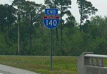
Interstate 140 (North Carolina)
| ||||
|---|---|---|---|---|
| John Jay Burney Jr. Freeway | ||||
_map.png) | ||||
| Route information | ||||
| Maintained by NCDOT | ||||
| Length: | 13.3 mi[1] (21.4 km) | |||
| Existed: | December 15, 2008[2] – present | |||
| Brunswick segment | ||||
| Length: | 6.5 mi (10.5 km) | |||
| West end: |
| |||
| East end: |
| |||
| New Hanover segment | ||||
| Length: | 6.8 mi (10.9 km) | |||
| West end: |
| |||
| East end: |
| |||
| Location | ||||
| Counties: | Brunswick, New Hanover | |||
| Highway system | ||||
| ||||


Interstate 140/North Carolina Highway 140 (I-140/NC 140) is a 13.3-mile (21.4 km) auxiliary Interstate Highway in the U.S. state of North Carolina. Broken in two segments, it serves as an incomplete bypass of Wilmington; providing a future direct route between the Grand Strand and Interstate 40. Officially known as the John Jay Burney Jr. Freeway, it is also known as the Wilmington Outer Loop, Wilmington Bypass and Northern Outer Loop.
Route description
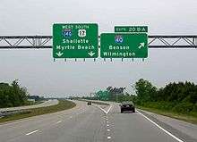
I-140 begins at its interchange with US 421 as a half cloverleaf northwest of downtown Wilmington.[3] From US 421, I-140 continues in a northeasterly direction where it crosses the Northeast Cape Fear River on the Dan Cameron Bridge.[4] After crossing the river, the route travels in an easterly direction where it meets North Carolina Highway 133 (NC 133) at Exit 18 as another half cloverleaf interchange in Wrightsboro.[5] From NC 133, I-140 continues to the east en route to its eastern terminus at a partial cloverleaf interchange with I-40 and US 17 in Murraysville.[6] The completed segment of I-140 is 6.7 miles (10.8 km) in length.[7]
The most notable feature of the existing route is the bridge spanning the Northeast Cape Fear River.[8] The bridge measures 1.43 miles (2.30 km) in length with a main span of 479 feet (146 m) and 82 feet (25 m) of vertical clearance above the river, Rat Island and adjacent marshlands.[9] Its construction consists of precast girders with cast-in-place decks leading to the main span consisting of cast-in-place cantilevered box girder elements.[9] In November 2005, the North Carolina Board of Transportation voted unanimously to name the I-140 bridge across the Northeast Cape Fear River in honor of former Wilmington mayor and businessman Dan Cameron.[10]
In an effort to protect scenic viewsheds for motorists utilizing the freeway, the Special Highway Overlay District of the New Hanover County Zoning Ordinance was adopted by the County Commission in June 2001.[11] Some of the restrictions of the overlay include the banning the construction of billboards, limiting outdoor storage and increasing setback requirements for structures adjacent to the roadway.[11][12] Only nine applications for billboards along I-140 were processed and approved prior to its passage.[11]
Dedicated and memorial names
I-140/NC 140 feature a two dedicated or memorialized stretches of freeway.
- Dan Cameron Bridge – Official North Carolina name of bridge over the Northeast Cape Fear River.
- Wilber E. Rabon Bridge – Official North Carolina name of bridge at the junction of I-140 and US 17, near Winnabow (approved: 02/06/2014).[13]
History
Preliminary designations
NCDOT may have tried two attempts to add I-140 in the state. The first appeared in the 1976 AAA map showing a proposed designation of I-140 between Beaucatcher Tunnel (US 70) and I-40 in east Asheville. The following year, the designation was changed to I-240, which would continue through Beaucatcher Tunnel (eventually through the Beaucatcher Cut when established) and replacing NC 191 to reconnect with I-40. It has not been confirmed if NCDOT actually submitted a request or not with AASHTO.
The second and confirmed preliminary designation was in 1999, when NCDOT submitted a request to AASHTO to designate 32.36 miles (52.08 km) of US 1 from I-40, in Raleigh, heading westerly to the future US 421 (Sanford Bypass) interchange, in Sanford. On April 17, 1999, the request was disapproved by the committee and has since been dropped.[14]
Northern Outer Loop
The idea of constructing a northern bypass for Wilmington was initially identified by the North Carolina Department of Transportation (NCDOT) as a need in 1972. The outer loop was viewed as a means to help relieve traffic congestion along Market Street and the Cape Fear Memorial Bridge through central Wilmington in New Hanover County [15] serving as both an additional crossing of the Cape Fear River and providing for better regional connectivity.[16] However, the project was not included as part of the department's construction schedule until 1989.[17] In 1991, NCDOT initiated the evaluation of a pair of proposed routes for the Northern Outer Loop.[18] The northern routing was to have been approximately 22 miles (35 km) in length and resulted in the relocation of 19 homes, 19 businesses, traversed 1,247 acres (5.05 km2; 1.95 sq mi) of wetlands, nine potential hazardous waste sites and five historic sites.[18] The southern routing was to have been approximately 20 miles (32 km) in length and resulted in the relocation of 58 homes, 8 businesses, traversed 2,064 acres (8.35 km2; 3.23 sq mi) of wetlands, seven potential hazardous waste sites and eight historic sites.[18]
In November 1994, North Carolina Board of Transportation elected to move forward with the southern routing.[19] The initial 5.8-mile (9.3 km) link between I-40 and US 421 was originally to begin construction in 1998 and open by 2001.[19] Due to significant opposition by both local residents and officials, NCDOT unveiled a revised routing in April 1996 that located the route 1-mile (1.6 km) north of the initial proposal.[20] This revised "central route" was selected as the final routing by NCDOT in April 1997.[17] At the time of its announcement, the route was estimated to cost $126.5 million to complete and result in the displacement of 20 homes, 8 businesses, the loss of 118 acres (0.48 km2; 0.18 sq mi) of wetlands and the loss of 290 acres (1.17 km2; 0.45 sq mi) of farmland lost.[17] Planning would continue through the late 1990s culminating with the first contract awarded for its construction in November 2000 for the I-40 interchange.[21]
I-140 designation
In 1997 local officials initially stated that an interstate designation was sought for the bypass.[22] In September 2002, the Federal Highway Administration announced that it would grant NCDOT's request and designate the Northern Outer Loop as Interstate 140.[23] The designation was to apply to the initial western segment constructed between I-40 and US 421 and the initial eastern segment constructed between I-40 and US 17.[23] At the time of its announcement, the designation was touted as a significant means to enhance economic development opportunities along its route in addition to potentially serving as a tie-in for moving the proposed eastern terminus of Interstate 74 from Myrtle Beach to Wilmington.[23] Later that month, it was announced the segment east of I-40, would be named the John J. Burney Freeway after the state senator and trustee of the University of North Carolina at Wilmington.[24]
The initial $36.7 million contract for construction of a 6.5-mile (10.5 km) segment of the eastern leg was awarded by NCDOT to Barnhill Contracting Company in November 2003.[25] Its construction had been delayed due to several conflicts including the handling of stormwater runoff into Futch Creek and a slight redesign of an off-ramp at the Porters Neck Road interchange to avoid a 450-year-old oak tree.[25][26] Construction of the eastern segment commenced on December 29, 2003.[27] As late as May 2005, NCDOT remained undecided as to whether or not to open only a portion of the road prior to completion of the elevated section due to the bridge section running behind schedule.[16] By summer NCDOT decided to open the first segment of I-140 to traffic on August 22, 2005.[28] Formally dedicated with Governor Mike Easley and U.S. Representative Mike McIntyre in attendance, the 3.2-mile (5.1 km) segment was located between I-40 and NC 133 (Castle Hayne Road).[28]
In June 2006, NCDOT announced two additional segments of the I-140 project would open by the end of the month.[29] Costing $187 million to complete, the US 17 expressway segment between Porters Neck Road and I-40 and the segment between NC 133 and US 421 both opened to traffic on June 30, 2006.[30] Concurrent with its opening, the routing of US 17 through Wilmington was also moved to the newly opened expressway. The previous routing of US 17 through Wilmington was changed to U.S. Highway 17 Business, and the US 17 Truck designation was removed from Military Cutoff Road and Oleander Drive upon the opening of the bypass with through trucks being directed to utilize the newly constructed freeway.[30]
Brunswick County construction
Originally, the freeway was scheduled to be extended from its current terminus at US 421 to US 74-76 first.[31] Construction began on this leg in 2014 and is scheduled to be the final segment of the route to open in 2017.[31]
In 2009, NCDOT announced plans to complete the southern portion of the western leg instead of the central portion requiring construction of a bridge across the Cape Fear River.[32] In response to this decision, city leaders from the town of Navassa filed a discrimination complaint against NCDOT claiming the town is frequently denied funding for infrastructure improvements and other projects.[33] Planning for future construction continued, and in March 2010 NCDOT awarded a $81.7 million contract to Barnhill Contracting Company.[34] The project involved the construction of the 6.118-mile (9.846 km) segment between the US 74/76 intersection and US 17 south of Leland.[34] Construction of the segment began in March 2010 as a result of receiving partial funding through the American Recovery and Reinvestment Act.[34]
As part of the expansion into Brunswick County, NCDOT designed several wildlife crossings to allow for the black bear and other animals to safely cross the corridor in the vicinity of the Battle Royal Natural Heritage Site.[35] The crossings included the extension of four bridges to provide some upland areas from animal crossings along water bodies and the construction of a 12-foot (3.7 m) by 6-foot (1.8 m) wildlife tunnel just north of the US 74-76 interchange.[35] This section of freeway was opened to traffic in September 2014.[36]
NC 140 designation
With the opening of the Brunswick segment, a new designation appeared, North Carolina Highway 140 (NC 140). On January 14, 2015, the Certification of Rulemaking was released confirming the establishment of the new designation along, not only the Brunswick segment, but all existing and future sections of the Wilmington bypass. The justification in the paperwork for using NC 140 was it would serve as a temporary designation until the entire bypass was complete and the remaining segments could be submitted to AASHTO approval as I-140.[37] The other rationalization was to provide an alternate designation for the entire Bypass if a proposal by NCDOT to return US 17 to the streets of Wilmington was enacted since only on the New Hanover segment is I-140 concurrent with US 17. NCDOT officials in the summer of 2014 called for returning US 17 to its original routing through Wilmington on Market Street, with the exception of placing a part of it on Military Cutoff Road and Oleander Drive, due to traffic volume on these roads being large enough to merit a route designation, which neither of these roads had. The proposal was endorsed by the Wilmington area Transportation Advisory Committee in August 2014.[38] AASHTO's Special Committee on U.S. Route Numbering approved the request on May 14, 2015.[39] It is not currently known when NC 140 signs will replace US 17 along the bypass.
Future
Construction for the remaining, missing link between US 421 and US 74/76 started in November 2014 with an expected date to open to traffic in fall 2017.[40]
A pair of additional exits have been proposed at both Blue Clay Road and the future extension of Military Cutoff Road. In 2002 the North Carolina Board of Transportation appropriated $10 million for the construction of an interchange at Blue Clay Road.[41] The interchange would serve in providing better access to both Wilmington International Airport and the Cape Fear Community College North Campus, and will be constructed sometime in the unspecified future.[29] The interchange at Military Cutoff Road would involve the extension of the road from its present terminus at Market Street approximately 4 miles (6.4 km) south.[42] Presently NCDOT has $18.1 million budgeted in 2012 to purchase the necessary right-of-way and move forward with preliminary engineering.[42]
A future toll road will extend this freeway 8 miles (13 km) further southeast, from US 17 to a terminus at US 421 and Independence Boulevard using the proposed Cape Fear Skyway bridge.[43]
Exit list
| County | Location | mi[7] | km | Exit | Destinations | Notes |
|---|---|---|---|---|---|---|
| Brunswick | | 0.0 | 0.0 | — | Continuation as US 17 | |
| | 1.0 | 1.6 | 1 | Left exit | ||
| Leland | 5.8 | 9.3 | 5 | Eastbound exit and westbound entrance | ||
| Mount Misery Road | Future interchange (under construction) | |||||
| Navassa | Cedar Hill Road | Future interchange (under construction) | ||||
| New Hanover | | 14.2 | 22.9 | 14 | South end of US 17 overlap, eastbound entrance and westbound exit | |
| NE Cape Fear River | 15.2 | 24.5 | Dan Cameron Bridge | |||
| Wrightsboro | 17.9 | 28.8 | 17 | |||
| Murraysville | 21.0 | 33.8 | 20A | Signed as exits 20A (west) and 20B (east) To UNC Wilmington | ||
| 20B | ||||||
| Kirkland | Military Cutoff Road | Future interchange (funded, construction to begin 2018) | ||||
| 25.7 | 41.4 | |||||
| 26.3 | 42.3 | — | Continuation as US 17 | |||
1.000 mi = 1.609 km; 1.000 km = 0.621 mi
| ||||||
References
- ↑ Google (July 4, 2013). "Interstate 140 (North Carolina)" (Map). Google Maps. Google. Retrieved July 4, 2013.
- ↑ "Vovici EFM Report: RN-08-03 (2008-12-15)" (PDF). North Carolina Department of Transportation. December 15, 2008. Retrieved July 4, 2013.
- ↑ Google (April 25, 2010). "Interstate 140/Exit 14 interchange" (Map). Google Maps. Google. Retrieved April 25, 2010.
- ↑ Google (April 25, 2010). "Interstate 140/Dan Cameron Memorial Bridge" (Map). Google Maps. Google. Retrieved April 25, 2010.
- ↑ Google (April 25, 2010). "Interstate 140/Exit 18 interchange" (Map). Google Maps. Google. Retrieved April 25, 2010.
- ↑ Google Maps street maps and USGS topographic maps, accessed April 25, 2010 via ACME Mapper
- 1 2 New Hanover County, North Carolina (PDF) (Map). NCDOT State Road Maintenance Unit - Mapping & Information Section. December 3, 2009. Retrieved December 18, 2010.
- ↑ McGrath, Gareth (February 27, 2000). "New roads should ease county's traffic problems". Star-News. Wilmington, NC. p. 14A.
- 1 2 "US-17 Wilmington Bypass". Miami, FL: GLF Construction Corporation. Retrieved April 26, 2010.
- ↑ Staff Report (November 3, 2005). "Bridge Named After Dan Cameron". Wilmington, NC: WECT TV6. Retrieved April 25, 2010.
- 1 2 3 Talton, Trista (November 5, 2002). "I-140 corridor will have more scenic views – Highway overlay zone means green space is a legal priority". Star-News. Wilmington, NC. p. 2B.
- ↑ New Hanover County Planning Department (March 2009). "Section 59.6: Special Highway Overlay District" (PDF). New Hanover County Zoning Ordinance. New Hanover County. pp. 72–73. Retrieved April 26, 2010.
- ↑ Staff (February 6, 2014). "Board of Transportation Meeting" (PDF). North Carolina Department of Transportation. p. 1113. Retrieved October 16, 2014.
- ↑ "Report of the Special Committee on U.S. Route Numbering to the Standing Committee on Highways, Saturday, April 17, 1999, Little Rock, Arkansas" (PDF). AASHTO. April 17, 1999. p. 5. Retrieved July 13, 2013.
- ↑ Enlarged Municipal & Suburban Areas of New Hanover County (Map). Sheet 3 of 6. Cartography by State Road Maintenance Unit – Mapping & Information Section. North Carolina Department of Transportation. December 9, 2009.
- 1 2 McGrath, Gareth (May 4, 2005). "Going up – Six months past due, the U.S. 17 Wilmington bypass bridge is still up in the air". Star-News. Wilmington, NC. p. 1B.
- 1 2 3 Hervey, Philip (April 24, 1997). "Northern Outer Loop; Central bypass route is chosen; 20 homes in path of U.S. 17 project". Star-News. Wilmington, NC. p. 1A.
- 1 2 3 Myers, Richard (June 11, 1994). "Northern Outer Loop; Environmental impact weighed for routes of planned roadway". Star-News. Wilmington, NC. p. 2B.
- 1 2 Hervey, Philip (November 5, 1994). "Board of transportation; 5.8-mile link between I-40 AND U.S. 421; State favors shorter of 2 routes for Outer Loop". Star-News. Wilmington, NC. p. 5B.
- ↑ Hervey, Philip (April 17, 1996). "Route moved; New plan for bypass brings little but groans". Star-News. Wilmington, NC. p. 2B.
- ↑ McGrath, Gareth (November 3, 2000). "1st U.S. 17 Wilmington bypass contract award is today". Star-News. Wilmington, NC. p. 1B.
- ↑ Fennell, Bettie (May 15, 1997). "Interstate status sought for bypass". Star-News. Wilmington, NC. p. 2B.
- 1 2 3 McGrath, Gareth (September 19, 2002). "Outer Loop named Wilmington's 2nd interstate". Star-News. Wilmington, NC. p. 1A.
- ↑ McGrath, Gareth (September 23, 2002). "Burney name goes on bypass". Star-News. Wilmington, NC. p. 1B.
- 1 2 McGrath, Gareth (November 6, 2003). "Awarding of contract moves loop forward". Star-News. Wilmington, NC. p. 1B.
- ↑ McGrath, Gareth (March 31, 2001). "Circling history; New highway to bypass aged tree". Star-News. Wilmington, NC. p. 1A.
- ↑ McGrath, Gareth (December 31, 2003). "Outer loop work starts eastward - Delays end for part of U.S. 17 project". Star-News. Wilmington, NC. p. 1A.
- 1 2 McGrath, Gareth (August 23, 2005). "First leg of I-140 is opened - road should ease area traffic". Star-News. Wilmington, NC. p. 1B.
- 1 2 McGrath, Gareth (June 20, 2006). "Two sections of Outer Loop opening soon". Star-News. Wilmington, NC. p. 1A. Retrieved April 25, 2010.
- 1 2 McGrath, Gareth (June 29, 2006). "Relief for commuters". Star-News. Wilmington, NC. p. 1A. Retrieved April 25, 2010.
- 1 2 Gannon, Patrick (July 15, 2009). "U.S. 17 bypass's Brunswick leg to be started earlier than planned". Star-News. Wilmington, NC. Retrieved April 26, 2010.
- ↑ Gannon, Patrick (September 16, 2009). "Navassa officials feeling bypassed by road-building schedule". Star-News. Wilmington, NC. Retrieved April 25, 2010.
- ↑ Little, Ken (October 15, 2009). "Navassa alleges DOT racial discrimination in U.S. 17 bypass schedule". Star-News. Wilmington, NC. Retrieved April 25, 2010.
- 1 2 3 Staff Reporters (March 10, 2010). "$81.7 million contract awarded for Brunswick segment of U.S. 17 bypass". Star-News. Wilmington, NC. Retrieved April 25, 2010.
- 1 2 McGrath, Gareth (November 29, 2009). "DOT to spend millions on 'critter crossings' for bears, other wildlife". Star-News. Wilmington, NC. Retrieved April 26, 2010.
- ↑ "After weather delays, next piece of Wilmington Bypass to open soon". wwaytv3.com. Retrieved 12 Dec 2014.
- ↑ "Route Changes (2015-01-14)" (PDF). North Carolina Department of Transportation. January 14, 2015. Retrieved February 17, 2015.
- ↑ McGrath, Gareth (August 27, 2014). "Committee endorses proposal to reroute U.S. 17 onto Wilmington city streets". Star-News. Wilmington, NC. Retrieved June 2, 2015.
- ↑ "SM 2015 USRN SCOH Report" (PDF). AASHTO. May 14, 2015. Retrieved June 2, 2015.
- ↑ "Work to start in November on bridges filling in Wilmington Bypass". wwaytv3.com. Retrieved 12 Dec 2014.
- ↑ McGrath, Gareth (September 22, 2002). "Budget includes highway project". Star-News. Wilmington, NC. Retrieved April 26, 2010.
- 1 2 Gannon, Patrick (August 23, 2007). "Traffic capacity at issue as I-140 link studied". Star-News. Wilmington, NC.
- ↑ Reynolds, David (April 22, 2010). "House District 17 hopefuls lukewarm on Skyway, port". Star-News. Wilmington, NC. Retrieved April 25, 2010.
External links
-
 Media related to Interstate 140 (North Carolina) at Wikimedia Commons
 - Media related to North Carolina Highway 140 at Wikimedia Commons
- Media related to Dan Cameron Bridge at Wikimedia Commons
- Interstate 140 North Carolina @ Interstate-Guide.com
- North Carolina @ SouthEastRoads.com - Interstate 140
- I-140 Wilmington Bypass @ NC Future Interstates
- I-140 Exit List
- NCRoads.com: I-140
| ||