Irazú Volcano National Park
| Irazú Volcano National Park | |
|---|---|
|
IUCN category II (national park) | |
|
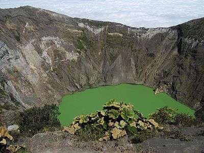
Irazú volcano crater | |
| Location | Costa Rica |
| Nearest city | Cartago |
| Coordinates | 9°58′44″N 83°51′7″W / 9.97889°N 83.85194°WCoordinates: 9°58′44″N 83°51′7″W / 9.97889°N 83.85194°W |
| Area | 20 km² |
| Established | 9 August 1955 |
| Governing body | National System of Conservation Areas (SINAC) |
Irazú Volcano National Park, or in Spanish the Parque Nacional Volcán Irazú, is a National Park in the Central Volcanic Conservation Area of Costa Rica that encompasses the area around the Irazú Volcano in Cartago Province which incorporates what used to be the Ruben Torres Rojas Forest Reserve now called the Prusia Forest Reserve. The volcano is still active although the last major eruptions were between 1963 and 1965, with occasional minor eruptions and some small lava flows since that time.
The park is the site of a reforestation project to restore the area which was destroyed by the eruptions. The forest is made up of conifers and other exotic and native species and also a native forest consisting mainly of oaks and alder, protecting the watershed of the Reventado River.
The Crater Principal lake has an unusual greenish yellow coloring caused by rainfall dissolving the minerals along the craters walls. It has also been known to change colour to rust-red depending on the minerals present. The inactive, dry Diego de la Haya crater sits just up to the right of the Crater Principal and is filled with volcanic ash.
External links
- Irazú Volcano National Park at Costa Rica National Parks
