Isis Temple
| Isis Temple | |
|---|---|
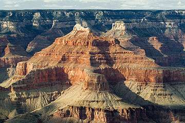
.jpg) Isis Temple id the structure on the right with the summit block | |
| Highest point | |
| Elevation | 7,006 ft (2,135 m) NGVD 29[1] |
| Prominence | 1,666 ft (508 m) [1] |
| Coordinates | 36°08′27″N 112°08′17″W / 36.1408156°N 112.137948°WCoordinates: 36°08′27″N 112°08′17″W / 36.1408156°N 112.137948°W [2] |
| Geography | |
 Isis Temple
| |
| Location |
Grand Canyon Coconino County, Arizona. U.S. |
| Topo map | USGS Shiva Temple |
| Geology | |
| Mountain type |
Coconino Sandstone-(prominence), Hermit Formation, Supai Group, Redwall Limestone, Muav Limestone, Bright Angel Shale, Shinumo Quartzite |
Isis Temple, in the Grand Canyon, Arizona, USA is a prominence below the North Rim, and adjacent Granite Gorge. The prominence lies north of the north bank of the west-flowing Colorado River, and is just north of Middle Granite Gorge. The Trinity Creek and canyon flow due-south at its west border; its north, and northeast border/flank is formed by Phantom Creek (Phantom Ranch) and canyon, a west tributary of Bright Angel Creek; the creeks intersect about 3 mi southeast, and 1 mi north of Granite Gorge.[3]
Isis Temple is about 5 mi directly north of Grand Canyon Village on the South Rim, Grand Canyon; the Village is the west terminus of Arizona Route 64-(East Rim Drive), and north terminus of U.S. 180, from Valle, Arizona, and Williams, (about 58 mi south).
Isis Temple is part of an uplifted, and sub-faulted block, (about 3.5 mi long x 2.0 mi wide),[4] with a sub-peak landform, Cheops Pyramid, 5,392 feet (1,643 m),[5] about 1600-ft (490 m) lower in elevation, and 1.0 mi[6] southeast of the Isis Temple prominence. The Isis prominence is composed of erosion resistant cliff-forming Coconino Sandstone.
Trails
The North Kaibab Trail accesses the Bright Angel Canyon route. Views of Isis Temple, or routes to the region are from the middle, or lower Bright Angel Canyon-Phantom Creek region, the flatlands around Isis, Cheops and the block southeast, called Utah Flats; one of the trails leads to the viewpoint at the Isis-Cheops Saddle. From the North Rim, the Tiyo Point Trail has views of Isis Temple from the north.
Geology
From Dana Butte region upon (west)-Tonto Trail, south Granite Gorge.
Right of Isis peak is the southwest cliff of the ridgeline: The Colonnade, at Tiyo Point; behind Isis peak is Tiyo Point, North Rim, and the Kaibab-Toroweap-Coconino Sandstone cliff sequence-(white-dark-white), and forested top, about 5.5-mi[7] from Dana Butte, Tonto Trail.
The prominence of Isis Temple is composed of the Coconino Sandstone, at 7,012 feet (2,137 m), (a similar elevation to the North Rim, Grand Canyon, Kaibab Plateau, and the Coconino is geologic member no. 2 of the 4 units of Permian age; unit 4, Kaibab Limestone makes up the Kaibab Plateau). Below the cliff-former Coconino Sandstone is eroded, slope-forming Hermit Shale, upon the uppermost Supai Group 'redbeds' member the cliff-forming, Esplanade Sandstone-(see Tuckup Trail). After the thick sequence of 'redbeds', the cliff-forming Redwall Limestone sits above highly eroded slopes of Muav Limestone and Bright Angel Shale. These slopes are deposited upon the cliff-forming unit of Shinumo Quartzite. The Shinumo Quartzite forms the cliff-base of Isis Temple, with highly erodable units forming the slopes below, the colorful, yellows, reds, and purplish colors from the Hakatai Shale, above the bottom Unkar Group member, Bass Formation-(in other photos shown as a well-bedded, grayish, multi-layered member, sitting on Vishnu Basement Rocks, at the top of Middle Granite Gorge).
The Shinumo Quartzite lies above the slope-forming unit of the Hakatai Shale, above Bass Formation. The two slope formers can be seen as reddish, yellowish, and purplish in photographs. From the south, three colorful slope-forming sections below the Shinumo Quartzite cliffs can be observed from a distance, one each below Isis Temple and Cheops Pyramid; a lower prominence has the third slope directly upon Granite Gorge, with the intersection of Bright Angel Creek/Canyon, located at the southeast section of the uplifted fault-block, that Isis Temple and Cheops Pyramid are part of.
Tapeats Sea, Shinumo Quartzite, and Unkar Group Horst
No Tapeats Sandstone was deposited upon the Shinumo Quartzite. In the Tapeats Sea, the marine transgression sequence of sandstone-(conglomerates)-shale-limestone found two 'mountain island' members, the Cardenas Basalt (sections), and the Shinumo Quartzite, as erosion resistant 'prominences'. Only the Bright Angel Shale and Muav Limestone were deposited above the 'mountain island' prominences; Tapeats Sandstone was deposited around the 'Shinumo Qurtzite island' perimeter, and can be seen in Bright Angel Canyon, west and northwest, the Phantom Creek drainage, north, and in the Trinity Creek drainage down the west perimeter, and upstream.
The Isis Temple-Cheops Pyramid is part of a localized fault-block, uplifted; (it also contains 3 sub-faults[8] within it, parallel to the fault at its north border, Phantom Creek);[9] the fault bordering the fault-block west, is down Trinity Creek; the fault east is the Bright Angel Fault, down Bright Angel Canyon, and on the south (South Rim side, 'south' of Middle Granite Gorge), through Garden Creek (canyon), of the Bright Angel Trail.
The Unkar Group, which forms the base of Isis Temple, consists of the Shinumo Quartzite, Hakatai Shale, and Bass Formation in descending order. The Unkar Group lies upon the Vishnu Basement Rocks, which are exposed in Lower, Middle, and Upper Granite Gorge. The Unkar Group, and other subdivisions of the (Grand Canyon Supergroup), are tilted, about 15 degrees, as seen in photographs, or while viewing in Grand Canyon.
List of geologic units of Isis Temple
The following is the list of geologic units below the Isis Temple prominence (for 5-member Unkar Group fault–block, members 3 through 1):
- Coconino Sandstone, (prominence, Permian unit 3 of 5 in Grand Canyon)
- Hermit Shale, Permian
- Supai Group, (4 units, Pennsylvanian-Permian)
- 4--Esplanade Sandstone, (Permian)
- 3--Wescogame Formation
- 2--Manakacha Formation
- 1--Watahomigi Formation
- (no Surprise Canyon Formation)
- Redwall Limestone
- Temple Butte Limestone
- Muav Limestone, (Tonto Group, unit 3 of 3)
- Bright Angel Shale, (Tonto Group, unit 2 of 3)
- 3--Shinumo Quartzite-(Unkar Group, 1,2,3 of 5)
- 2--Hakatai Shale
- 1--Bass Formation
- Vishnu Basement Rocks
Observation viewpoints
Isis Temple can be viewed from the South Rim, from the viewpoints, west and east of Grand Canyon Village, Arizona. Hopi Point (west), and Yavapai Point (east), are both at Grand Canyon Village, and due-south of Isis Temple.
Isis Temple can be viewed from the North Rim, Bright Angel Point region; Isis Temple prominence is about 3-mi due south of Tiyo Point-(Tiyo Point Trail), and Isis and Cheops Pyramid are about 5-mi southwest of Bright Angel Point.[10]
References
- 1 2 "Isis Temple". ListsOfJohn.com. Retrieved 2016-08-17.
- ↑ "Isis Temple". Geographic Names Information System. United States Geological Survey. Retrieved 2016-08-17.
- ↑ Arizona Road & Recreation Atlas, Benchmark Maps, p. 28.
- ↑ Arizona Road & Recreation Atlas, Benchmark Maps, p. 12-13.
- ↑ Arizona Road & Recreation Atlas, Benchmark Maps, p. 12-13.
- ↑ Arizona Road Atlas, Benchmark Maps, p. 12.
- ↑ Arizona Road & Recreation Atlas, Benchmark Maps, p. 28.
- ↑ Chronic, Halka. Roadside Geology of Arizona, from Section: "Grand Canyon National Park", pp. 279-287. Graphic, Faults of eastern Grand Canyon show a NW-SE trend superimposed on a NE-SW trend inherited from Precambrian time. In Grand Canyon these faults can be studied in three-dimensional detail. (about 35 faults shown), p. 286.
- ↑ Chronic, Halka. Roadside Geology of Arizona, p. 286.
- ↑ Arizona Road & Recreation Atlas, Benchmark Maps, p. 28.
Additional sources
- Arizona Road & Recreation Atlas, Benchmark Maps, 2nd Edition, c. 1998, 112 pages, pp. 28–29, 62-63.
- Arizona DeLorme Atlas & Gazetteer, 5th Edition, c. 2002, 76 pages, pp. 31, 23.
- Chronic, Halka. Roadside Geology of Arizona, c. 1983, 23rd printing, Mountain Press Publishing Co. 322 pages. pp. 229–232-(US 89A Marble Canyon – Fredonia), pp. 179–180. (softcover, ISBN 978-0-87842-147-3)
- Lucchitta, 2001. Hiking Arizona's Geology, Ivo Lucchitta, c 2001, Mountaineers's Books. (softcover, ISBN 0-89886-730-4)
External links
| Wikimedia Commons has media related to |
- Isis Temple, (at Phantom Creek, Trinity Creek, Bright Angel Canyon), above Granite Gorge (lat-long.com), coordinates, Coconino County, AZ
- Geologic map--Isis Temple and Bright Angel Fault region
- Geologic map: Isis Temple region & Bright Angel Fault, website photos
|
|

