Itaituba
| Itaituba, Pará, Brazil | |||
|---|---|---|---|
| City | |||
 | |||
| |||
| Nickname(s): "Golden City (Cidade Pepita, in Portuguese)" | |||
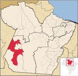 Location of Itaituba in the State of Pará, Brazil | |||
 Itaituba, Pará, Brazil Location of Itaituba in Brazil | |||
| Coordinates: 4°16′33″S 55°59′2″W / 4.27583°S 55.98389°W | |||
| Country |
Brazil | ||
| Region | North | ||
| State |
| ||
| Founded | December 15, 1856 | ||
| Government | |||
| • Mayor | Eliene Nunes (PSD) | ||
| Area | |||
| • Total | 62,040.947 km2 (23,954.144 sq mi) | ||
| Elevation | 15 m (49 ft) | ||
| Population (2011) | |||
| • Total | 97,704 | ||
| • Density | 1.57/km2 (4.1/sq mi) | ||
| Time zone | AST (UTC-4) | ||
| • Summer (DST) | DST no longer used (UTC-4) | ||
| Postal Code | 68180-000 | ||
| Area code(s) | 93 | ||
| HDI (2000) | 0.704 – medium | ||
| Website |
www | ||


Itaituba is a city and municipality located in the state of Pará, Brazil, and one of the most important socioeconomic centers in the western region of the State.[1]
Itaituba is the fifteenth largest city (by population) in the State of Pará,[2] third largest city in the western region, and has the thirteenth largest Gross Domestic Product in the State. The city is regarded as a medium-sized city,[3] and one of the fastest growing cities in the countryside of Brazil.[4] The name of the city origins from Tupi (an indigenous language), which literally means gravel place.[5]
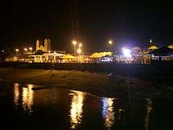
People from the city of Itaituba are known as itaitubenses. The city motto is cidade pepita, which translates as "golden city." The city is known for the intense gold mining activity in the valley of the Tapajós River, the multitude of landscapes (such as the sandy river beaches that are formed during the dry seasons, and also the waterfalls located in the district of São Luiz do Tapajós), and the Amazônia National Park.
History
Early History
The presence of Dutch, French, and English explorers in the estuary of the Amazon River has concurred for the settlement of Portuguese expeditionaries in the current territory of the State of Pará, and also for the expedition of Francisco Caldeira Castelo Branco which, in 1616, has founded the city of Belém.
After the foundation of the captaincy of Grão Pará, the foreigners were gradually expelled by the government, by means of various expeditions which had as goal to destroy the settlements created. Among these expeditions, the one headed by captain Pedro Teixeira reached for the first time (in 1626) the Tapajós River. This expedition established a friendly contact with native people in the site currently known as Alter-do-Chão bay. In 1639, Pedro Teixeira returned to the Tapajós River, being followed the Jesuits.
Several villages were founded by the Jesuits, along the Tapajós River, during this period. Some of these villages were "Tapajós", in 1661, "São José" (or Matapus), in 1722, "São Inácio" (or Tupinambaranas), in 1737, and Borari and Arapiuns.
During the administration of the governor and captain-general Francisco Xavier de Mendonça Furtado, the government retracted the Jesuits from these villages, and raised the Tapajós village to the category of town, with the denomination of Santarém. There were also changes in the villages of Borari and Arapiuns, in 1757, which were denominated Alter-do-Chão and Vila Franca, respectively. And, in 1758, the villages of São Inácio and São José were denominated as Boim and Pinhel.
_em_Itaituba.jpg)
During the administration of José de Nápoles Telo de Menezes the village of Aveiro was founded. In this village was installed, in 1781, the parish of Our Lady of Conception (Nossa Senhora da Conceição).
It is known, from the footage and historical evidence available, that the place of Itaituba already existed by the year of 1812, since it was mentioned in the travel list of Miguel João de Castro alongside the Tapajós River, as a center of exploration and trade of specialties of the High Tapajós.
With the Revolution of Cabanagem and the events that occurred during this period, the village of Brasília Legal was founded, in 1836, as a place for resistance of the rebels, on the left bank of the Tapajós River.
According to Ferreira Penna, in 1836 Itaituba was an indigenous village, belonging to the province of Grão Pará, in which a small military base was installed.
Among the most relevant people associated to the foundation of Itaituba, one of remarkable importance is Joaquim Caetano Corrêa, because of its pioneer work on the exploration of the tapajonic region, being even regarded as the founder of the municipally seat.
Itaituba depended on the parish of Pinhel until 1853, when it was transferred to the jurisdiction of Boim.
Geography
The city is located at latitude 04º16'34" S and longitude 55º59'01" W, on the left bank of the Tapajós River.
The municipality contains part of the Trairão National Forest, in which logging is permitted subject to a management plan.[6] It also contains part of the 724,965 hectares (1,791,430 acres) Altamira National Forest, a sustainable use conservation unit created in 1998.[7] It contains part of the Itaituba I and Itaituba II national forests, both established in 1998, which have a combined area of 610,472 hectares (1,508,510 acres).[8] It contains part of the Jamanxim National Park, a fully protected area.[9] It also holds part of the 538,151 hectares (1,329,800 acres) Rio Novo National Park, a conservation unit created in 2006.[10] It contains part of the Amaná National Forest, a 539,571 hectares (1,333,310 acres) sustainable use conservation unit created in 2006.[11]
Climate
The climate of the region is equatorial, with an average minimum daily temperature greater than 18 °C. Itaituba has a relative humidity of the air above 80% during almost all the months of the year. The rainy season includes the months of December to April, while the driest months are from July to October.
| Climate data for Itaituba, Pará, Brazil | |||||||||||||
|---|---|---|---|---|---|---|---|---|---|---|---|---|---|
| Month | Jan | Feb | Mar | Apr | May | Jun | Jul | Aug | Sep | Oct | Nov | Dec | Year |
| Average high °C (°F) | 31 (88) |
30 (86) |
31 (88) |
31 (88) |
31 (88) |
32 (90) |
32 (90) |
33 (91) |
33 (91) |
33 (91) |
33 (91) |
32 (90) |
32 (89) |
| Average low °C (°F) | 22 (72) |
22 (72) |
22 (72) |
23 (73) |
23 (73) |
22 (72) |
21 (70) |
22 (72) |
22 (72) |
23 (73) |
23 (73) |
23 (73) |
22 (72) |
| Average precipitation mm (inches) | 206 (8.11) |
292 (11.5) |
276 (10.87) |
231 (9.09) |
188 (7.4) |
109 (4.29) |
69 (2.72) |
91 (3.58) |
74 (2.91) |
84 (3.31) |
127 (5) |
201 (7.91) |
1,948 (76.69) |
| Source: The Weather Channel[12] | |||||||||||||
Culture
The biggest festival in Itaituba is Our lady de Santana's Party, for padroeira of the municipal district, the festivities are during the first fortnight of July and finishes with Círio's Procession, same month on the 26th, dedicated to that holy.
Transportation
The city is served by Itaituba Airport.
References
- ↑ "Encanto do Tapajós". Revista VoeTRIP. Spring. Archived from the original on January 2010. Retrieved December 21, 2011.
- ↑ "Population Estimate 2011". Population Estimate 2011. IBGE. Archived from the original on December 21, 2011. Retrieved December 21, 2011.
- ↑ "Regiões de Influência das Cidades – 2008". IBGE. Archived from the original on August 10, 2008. Retrieved September 19, 2010.
- ↑ "O Brasil em 10 vocações". Especial Cidades Médias – Almanaque. Revista Veja. September 1, 2010. Retrieved 9 September 2010.
- ↑ http://www.fflch.usp.br/dlcv/tupi/vocabulario.htm
- ↑ Plano de Manejo da Floresta Nacional do Trairão, Localizada no Estado do Pará (PDF), Brasília – DF: ICMBio, p. 4, retrieved 2016-05-19
- ↑ Unidade de Conservação: Floresta Nacional Altamira (in Portuguese), MMA: Ministério do Meio Ambiente, retrieved 2016-05-29
- ↑ Florestas Nacionais de Itaituba I e II (PA) (in Portuguese), Serviço Florestal Brasileiro, retrieved 2016-05-29
- ↑ Unidade de Conservação: Parque Nacional do Jamanxim (in Portuguese), MMA: Ministério do Meio Ambiente, retrieved 2016-05-19
- ↑ Unidade de Conservação: Parque Nacional do Rio Novo (in Portuguese), MMA: Ministério do Meio Ambiente, retrieved 2016-05-27
- ↑ Unidade de Conservação: Floresta Nacional do Amaná (in Portuguese), MMA: Ministério do Meio Ambiente, retrieved 2016-05-30
- ↑ "Climatology – Itaituba, Pará, Brazil – The Weather Channel".
External links
| Wikimedia Commons has media related to Itaituba. |
| Wikivoyage has a travel guide for Itaituba. |