Iullemmeden Basin

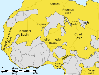
The Iullemmeden Basin is a major sub-Saharan inland basin in West Africa, extending about 1000 km north to south and 800 km east to west. It covers western Niger and portions of Algeria, Mali, Benin and Nigeria. It is named after the Iullemmeden, a federation of Tuareg people who live in the central region of Niger.[1] Its geographic range is largely coincident with the Azawagh region.[2]
The area of the Iullemmeden Basin seems to have started to subside in Permo-Triassic times, and to have experienced gradual downwarping during the Upper Cretaceous - Lower Tertiary times, while steadily filling with sediment. Two prominent fault trends run NNE-SSW through the center of the basin, while WSW-ENE faults trends are found in the northeast of the basin near the Aïr Mountains.[1] The sediments from Cambrian to Pleistocene times are 1,500 to 2,000 meters deep, with alternating layers formed when the basin was undersea and above sea level. Potentially valuable minerals include uranium and copper ores and coal and salt deposits. Niger is one of the world's largest producers of Uranium.[3]
References
- 1 2 Richard C. Selley (1997). "The Iullemmeden Basin". African basins. Elsevier. p. 89ff. ISBN 0-444-82571-1.
- ↑ Paris, François (1995). "L Bassin de I'Azawagh : peuplements et civilisations, du néolithique à l'arrivée de l'islam" (PDF). Milieux, sociétés et archéologues (in French). Karthala. p. 228. Retrieved 3 April 2012.
- ↑ "URANIUM GEOLOGY: NIGER, WEST AFRICA" (PDF). NWT Uranium Corporation. Retrieved 2010-12-18.
Further reading
- "ICONS atlas: AFR - Iullemmeden Basin". Earth Byte. Retrieved 2010-12-18.