Iupshara River
| Iupshara | |
| River | |
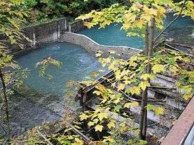 The Iupshara at its source | |
| Country | Georgia (Abkhazia[1]) |
|---|---|
| Source | Lake Ritsa |
| - coordinates | 43°28′17″N 40°32′01″E / 43.47139°N 40.53361°E |
| Mouth | |
| - location | Gega River |
| - coordinates | 43°24′34″N 40°27′44″E / 43.40944°N 40.46222°ECoordinates: 43°24′34″N 40°27′44″E / 43.40944°N 40.46222°E |
| Length | 12.6 km (8 mi) |
| Basin | 170 km2 (66 sq mi) |
The Iupshara (Georgian: იუფშარა, Russian: Юпшара) is a river in northern Abkhazia.[1] The river flows from Lake Ritsa to the Gega River, a tributary of the Bzyb River.
The total length of the river is 12.6 km (7.8 mi) with a gradient of 48.7 m/km (257 ft/mi). It drains an area of 170 km2 (66 sq mi). The highest discharge of the Iupshara is in May, 29.6 m3/s (1,050 cu ft/s), and the lowest in February, 0.94 m3/s (33 cu ft/s).[2]
References
- 1 2 Abkhazia's status is disputed. It considers itself to be an independent state, but this is recognised by only a few other countries. The Georgian government and most of the world's other states consider Abkhazia de jure a part of Georgia's territory. In Georgia's official subdivision it is an autonomous republic, whose government sits in exile in Tbilisi.
- ↑ "о водном путешествии с эл. 5 к.с. по р.р.Юпшара-Гега-Бзыбь, совершённому на катамаранах с 30 августа по 9 сентября 2005г. группой из г. Москвы под руководством Боброва А.В.". Retrieved 2016-11-27.
This article is issued from Wikipedia - version of the 12/5/2016. The text is available under the Creative Commons Attribution/Share Alike but additional terms may apply for the media files.