Ivyton, Kentucky
| Ivyton | |
|---|---|
| Unincorporated community | |
 Ivyton  Ivyton Location within the state of Kentucky | |
| Coordinates: 37°42′32″N 82°58′43″W / 37.70889°N 82.97861°WCoordinates: 37°42′32″N 82°58′43″W / 37.70889°N 82.97861°W | |
| Country | United States |
| State | Kentucky |
| County | Magoffin |
| Elevation | 984 ft (300 m) |
| Time zone | Eastern (EST) (UTC-5) |
| • Summer (DST) | EDT (UTC-4) |
| GNIS feature ID | 508324 |
Ivyton is an unincorporated community in Magoffin County, Kentucky, United States. It lies along Route 114 southeast of the city of Salyersville, the county seat of Magoffin County.[1] Its elevation is 984 feet (300 m).[2]
A post office was established in the community in 1883. The town was named for the natural abundance of ivy.[3]
References
- ↑ Rand McNally. The Road Atlas '06. Chicago: Rand McNally, 2006, p. 43.
- ↑ U.S. Geological Survey Geographic Names Information System: Ivyton, Kentucky, Geographic Names Information System, 1979-09-20. Accessed 2008-01-03.
- ↑ Rennick, Robert M. (1987). Kentucky Place Names. University Press of Kentucky. p. 151. Retrieved 2013-07-26.
Municipalities and communities of Magoffin County, Kentucky, United States | ||
|---|---|---|
| City | 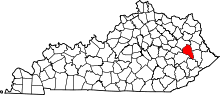 | |
| Unincorporated communities | ||
This article is issued from Wikipedia - version of the 10/11/2016. The text is available under the Creative Commons Attribution/Share Alike but additional terms may apply for the media files.