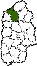
Iziaslav Raion
| Iziaslav Raion Ізяславський район | |||
|---|---|---|---|
| Raion | |||
| |||
 | |||
| Country |
| ||
| Region | Khmelnytskyi Oblast | ||
| Established | March 7, 1923 | ||
| Admin. center | Iziaslav | ||
| Subdivisions |
List
| ||
| Government | |||
| • Governor | Mihail S. Borisyuk | ||
| Area | |||
| • Total | 1,250 km2 (480 sq mi) | ||
| Population | |||
| • Total | 45,233 | ||
| • Density | 36/km2 (94/sq mi) | ||
| Time zone | EET (UTC+2) | ||
| • Summer (DST) | EEST (UTC+3) | ||
| Postal index | 30300—30375 | ||
| Area code | 380-3852 | ||
| Website |
izadm | ||

Iziaslav Raion (Ukrainian: Ізяславський район) is a raion in Khmelnytskyi Oblast in Ukraine. Its administrative center is Iziaslav. Its population is 46,745 inhabitants (2011).[1] It was established in 1923. One city and ninety-one villages are located in Iziaslavskyi Raion.
Geography
Iziaslav Raion is a part of Volhynia. It is one out 20 raions of Khmelnytskyi Oblast. It is a large raion and ranks as the 2th among the largest with respect to the total area (1,258 km2 corresponding to 6.1% of the total area of Khmelnytskyi Oblast).
Iziaslav Raion is southwest of Rivne Oblast (Ostroh Raion), northeast of Slavuta Raion, west of Shepetivka Raion, north of Krasyliv Raion, and northeast of Teofipol Raion and Bilohiria Raion. The Horyn, Vilia, Homora, Hnylyi Rig and other rivers flow through the district. There are rail lines through the district (Shepetivka—Ternopil and Shepetivka—Starokostiantyniv).
History
From 1923 to 1932 the district was part of the Shepetivka region, then from 1932 to 1937 it was part of the Vinnytsia region. Following that from 1937 to 1954 it was part of the Kamenets Podolsk region. Since 1954 it has been part of the Khmelnytskyi region. Finally Iziaslavskyi Raion was formed September 23, 1959.[2]
References
External links
- ic.km.ua/~izrda (Ukrainian)
-
 Media related to Iziaslav Raion at Wikimedia Commons
 |
Radyvyliv Raion, Rivne Oblast | Slavuta Raion | | |
| Bilohiria Raion | |
Shepetivka Raion | ||
| ||||
| | ||||
| Teofipol Raion | Krasyliv Raion |
| Raions | |||||||
|---|---|---|---|---|---|---|---|
| Cities |
| ||||||
| |||||||