Jackson Creek (Victoria)
| Jackson | |
| Saltwater River Western Branch, Gisborne Creek, Macedon River, Saltwater River, Saltwater Creek[1] | |
| Creek | |
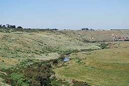 The narrow valley cut by Jackson Creek near Clarkefield | |
| Name origin: After early Colonial settlers, 'Hungry' William Jackson[2] | |
| Country | Australia |
|---|---|
| State | Victoria |
| Regions | Victorian Midlands (IBRA), Greater Melbourne |
| Local government area | Macedon Ranges Shire |
| Part of | Port Phillip catchment |
| Tributaries | |
| - left | Riddells Creek |
| - right | Longview Creek |
| Suburbs | Gisborne, Sunbury |
| Source | Macedon Ranges, Great Dividing Range |
| Source confluence | Distill, Gisborne and Slaty creeks |
| - location | within Rosslynne Reservoir, northwest of Gisborne |
| - elevation | 459 m (1,506 ft) |
| - coordinates | 37°28′9″S 144°34′4″E / 37.46917°S 144.56778°E |
| Mouth | confluence with the Deep Creek to form the Maribyrnong River |
| - location | west of Melbourne Airport |
| - elevation | 42 m (138 ft) |
| - coordinates | 37°40′10″S 144°48′16″E / 37.66944°S 144.80444°ECoordinates: 37°40′10″S 144°48′16″E / 37.66944°S 144.80444°E |
| Length | 71 km (44.1 mi) |
| National park | Organ Pipes NP |
| Reservoir | Rosslynne Reservoir |
 Contour map of the Maribyrnong River basin; Jackson Creek rises midpoint between the 400–500-metre (1,300–1,600 ft) contour line. | |
| Wikimedia Commons: Jackson Creek (Victoria) | |
| [3] | |
The Jackson Creek (sometimes incorrectly spelled as Jacksons Creek[1]) is a watercourse of the Port Phillip catchment, located in the outer northern suburbs of Melbourne, in the Australian state of Victoria.
Location and features

Formed by the confluence of the Distill, Gisborne and Slaty creeks that drain the southern parts of the Macedon Ranges, part of the Great Dividing Range through the Black Forest, the Jackson Creek rises northwest of Gisborne, within the Rosslynne Reservoir. The creek flows east, then south, then south by east, joined by two minor tributaries before reaching its confluence with the Deep Creek to form the Maribyrnong River west of Melbourne Airport.[3] In its upper reaches the creek flows east in a broad shallow valley in the Bullengarook area, then enters the deeper, narrower valley that characterises the remainder of the watercourse. The creek flows through the town of Gisborne before turning generally southwards to flow through Sunbury eventually to join with Deep Creek south of Bulla, where the two waterways form the Maribyrnong River. The deep and relatively narrow valley cut by the creek in its southward course through the surrounding basalt plains is particularly prominent at such places as Emu Bottom and the Organ Pipes National Park. The creek descends 417 metres (1,368 ft) over its 71-kilometre (44 mi) course.[3]
The incised meanders of the Jackson Creek demonstrate the downcutting of the Newer Volcanics and have formed rapids and small falls, along with outcrops of columnar basalts and tessellated pavements, for example at the Organ Pipes National Park near the Calder Freeway, a prominent display of basaltic columns so named because they look like organ pipes. Upstream, a bluestone flour mill near the falls south of Sunbury harnessed the major drop in river levels.[4]
Etymology
The creek was named after the early Colonial settlers William Jackson and his brother, Samuel,[2] who named the township of Sunbury after Sunbury-on-Thames, in Surrey, England when it was established in 1857.
By inference, as Deep Creek has been called the east branch of the Maribyrnong River,[5] Jackson Creek could be considered the west branch. The creek has also historically been called Saltwater River Western Branch, Gisborne Creek, Macedon River, Saltwater River, and Saltwater Creek.[1][6]
Crossings
Named and other significant bridges and crossing points along Jackson Creek include but are not limited to the following:
- Holden Bridge (early concrete beam bridge replacing an earlier ford on Bulla - Diggers Rest Road)
- Jacksons Creek bridge (Sunbury, historic twin arch bluestone bridge, pedestrians only)
- Sunbury railway viaduct (constructed 1859 for Bendigo Rail Line)
- Black Hill Bridge (Settlement Road)
- Old Jacksons Creek Bridge (pedestrians only)
- Jacksons Creek Bridge (Riddell Road)
- Calder Freeway
- Gisborne - Kilmore Road
- Aitken Street
- Waterloo Flat Road
See also
References
- 1 2 3 "Jackson Creek: 18034". VICNAMES. Government of Victoria. Retrieved 15 April 2014.
- 1 2 "Jackson Creek: 18034: Historical information". VICNAMES. Government of Victoria. 10 May 2012. Retrieved 15 April 2014.
- 1 2 3 "Map of Jackson Creek, VIC". Bonzle Digital Atlas of Australia. Retrieved 15 April 2014.
- ↑ Rosengren, Neville (1986). "Sites of Geological and Geomorphological Significance in the Western Region of Melbourne". Victoria: Department of Primary Industry.
- ↑ Victorian Municipal Directory. Brunswick: Arnall & Jackson. 1956. p. 791.
- ↑ Melway Greater Melbourne Street Directory. Glen Iris: Melway. various editions, 1991-2006. 197. Check date values in:
|date=(help)
Waterways of the Greater Melbourne catchment, Victoria, Australia | |
|---|---|
| Ocean inlets, harbours and bays | |
| Rivers | |
| Creeks |
|
| Lagoons and lakes | |
| Adjoining rivers and bays | |
| |
| Port Phillip sub-catchment |
|
|---|---|
| Western Port sub-catchment | |
| |