Jambi
| Jambi Province Provinsi Jambi جمبي | |||
|---|---|---|---|
| Province | |||
|
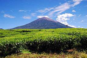
Mount Kerinci, the highest peak in Sumatra Island | |||
| |||
|
Motto: Sepucuk Jambi Sembilan Lurah (Malay proverb) (One united Jambi, formed from nine regional entities) | |||
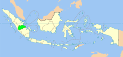 Location of Jambi in Indonesia | |||
| Coordinates: 1°35′S 103°37′E / 1.583°S 103.617°ECoordinates: 1°35′S 103°37′E / 1.583°S 103.617°E | |||
| Country | Indonesia | ||
| Capital | Jambi City | ||
| Government | |||
| • Governor | Zumi Zola (National Mandate Party) | ||
| • Vice Governor | Fachrori Umar | ||
| Area | |||
| • Total | 50,058.16 km2 (19,327.56 sq mi) | ||
| Population (2014 Estimate) | |||
| • Total | 3,412,459 | ||
| • Density | 68/km2 (180/sq mi) | ||
| Demographics | |||
| • Ethnic groups | Malay (38%), Javanese (28,8%), Kerinci (10%), Minangkabau (5,2%), Batak (3,43%), Banjarese (3,3%), Buginese (3,1%), Sundanese (2,56%), Tionghoa (1,2%), Other (4,41%)[1] | ||
| • Religion | Muslim (96.5%), Christian (3%), Buddhist (1%), Hindu (0.117%) | ||
| • Languages | Indonesian, Jambi Malay, Kerinci, Kubu | ||
| Time zone | WIB (UTC+7) | ||
| Vehicle registration | BH | ||
| HDI |
| ||
| HDI rank | 16th (2014) | ||
| Website | jambiprov.go.id | ||

Jambi (Indonesian: Provinsi Jambi, Jawi: جمبي), is a province of Indonesia. It is located on the east coast of central Sumatra and its capital is Jambi.
The province has a land area of 50,058.16 km2, and it has a population of 3,092,265 according to the 2010 Census;[2] by January 2014 this had risen to 3,412,459.
History
Jambi was the site of the Srivijayan kingdom that engaged in trade throughout the Strait of Malacca and beyond. Jambi succeeded Palembang, its southern economic and military rival, as the capital of the kingdom. The movement of the capital to Jambi was partly induced by the 1025 raid by pirates from the Chola region of southern India, which destroyed much of Palembang.
In the early decades of the Dutch presence in the region (see Dutch East India Company in Indonesia), when the Dutch were one of several traders competing with the British, Chinese, Arabs, and Malays, the Jambi Sultanate profited from trade in pepper with the Dutch. This relationship declined by about 1770, and the sultanate had little contact with the Dutch for about sixty years.
In 1833, minor conflicts with the Dutch (the Indonesian colonial possessions of which were now nationalised as the Dutch East Indies) who were well established in Palembang, meant the Dutch increasingly felt the need to control the actions of Jambi. They coerced Sultan Facharudin to agree to greater Dutch presence in the region and control over trade, although the sultanate remained nominally independent. In 1858 the Dutch, apparently concerned over the risk of competition for control from other foreign powers, invaded Jambi with a force from their capital Batavia. They met little resistance, and Sultan Taha fled upriver, to the inland regions of Jambi. The Dutch installed a puppet ruler, Nazarudin, in the lower region, which included the capital city. For the next forty years Taha maintained the upriver kingdom, and slowly reextended his influence over the lower regions through political agreements and marriage connections. In 1904, however, the Dutch were stronger and, as a part of a larger campaign to consolidate control over the entire archipelago, soldiers finally managed to capture and kill Taha, and in 1906, the entire area was brought under direct colonial management.
Following the death of Jambi sultan, Taha Saifuddin, on April 27, 1904 and the success of the Dutch controlled areas of the Sultanate of Jambi, Jambi then set as the Residency and entry into the territory Nederlandsch Indie. Jambi's first Resident OL Helfrich was appointed by the Governor General of the Dutch Decree No. 20 dated May 4, 1906 and his inauguration held on July 2, 1906.
| Historical population | ||
|---|---|---|
| Year | Pop. | ±% |
| 1971 | 1,006,084 | — |
| 1980 | 1,445,994 | +43.7% |
| 1990 | 2,020,568 | +39.7% |
| 1995 | 2,369,959 | +17.3% |
| 2000 | 2,407,166 | +1.6% |
| 2010 | 3,092,265 | +28.5% |
| Source: Badan Pusat Statistik 2014 | ||
Administrative divisions
Jambi province is divided into nine regencies (kabupaten) and two cities (kota), listed below with their areas and their populations at the 2010 Census and according to the latest (January 2014) estimates.
| Name | Area (km2) | Population Census 2010 | Population Estimate 2014 | Capital |
|---|---|---|---|---|
| Jambi City | 103.54 | 531,857 | 586,930 | - |
| Sungai Penuh City | 391.50 | 82,293 | 90,814 | - |
| Batanghari Regency | 5,804.00 | 241,334 | 266,323 | Muara Bulian |
| Bungo Regency | 4,659.00 | 303,135 | 334,524 | Muara Bungo |
| East Tanjung Jabung Regency (Tanjung Jabung Timur) | 5,445.00 | 205,272 | 226,527 | Muara Sabak |
| Kerinci Regency | 3,355.27 | 229,495 | 253,258 | Siulak |
| Merangin Regency | 7,679.00 | 333,206 | 367,708 | Bangko |
| Muaro Jambi Regency | 5,326.00 | 342,952 | 378,464 | Sengeti |
| Sarolangun Regency | 6,184.00 | 246,245 | 271,743 | Sarolangun |
| Tebo Regency | 6,461.00 | 297,735 | 328,564 | Muara Tebo |
| West Tanjung Jabung Regency (Tanjung Jabung Barat) | 4,649.85 | 278,741 | 307,604 | Kuala Tungkal |
| Total province | 50,058.16 | 3,092,265 | 3,412,459 | Jambi |
Languages
In addition to an urban Malay koine (Jambi Malay) spoken in Jambi city, Kerinci, Kubu, Lempur Malay, and Rantau Panjang Malay are also spoken in Jambi province.[3]
World Heritage Site
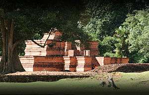
May 2011: The Jambi provincial administration is striving to have the ancient Muaro Jambi temple site at Muaro Jambi village in Maro Sebo District, Muaro Jambi Regency, recognized as a world heritage site.
The site was a Buddhist education center that flourished during the 7th and 8th centuries and is made from bricks similar to those used in Buddhist temples in India.[4]
Recreation

- Taman Tanggo Rajo
This is Jambi's essential evening destination for riverside promenading. Stalls sell local favourites, such as nanas goreng (fried pineapples) and jagung bakar (roasted corn slathered with coconut milk and chillis). The sate Padang is also good. Nearby is the Wiltop Trade Centre, a modern shopping mall with Western restaurants and a multiplex cinema.
It’s easy to spend all day at Muara Jambi. The forested site covers 12 km2 along the north bank of the Batang Hari. The entrance is through an ornate archway in the village of Muara Jambi and most places of interest are within a few minutes’ walk.
Eight temples have been identified, each at the centre of its own low-walled compound. Some are accompanied by perwara candi (smaller side temples) and three have been restored to something close to their original form. The site is dotted with numerous menapo (smaller brick mounds), thought to be the ruins of other buildings – possibly dwellings for priests and other high officials.
The restored temple Candi Gumpung, straight ahead of the donation office, has a fiendish makara (demon head) guarding its steps. Excavation work here has yielded some important finds, including a peripih (stone box) containing sheets of gold inscribed with old Javanese characters, dating the temple back to the 9th century. A statue of Prajnyaparamita found here is now the star attraction at the small site museum nearby.
Candi Tinggi, 200m southeast of Candi Gumpung, is the finest of the temples. It dates from the 9th century but is built around another, older temple. A path leads east from Candi Tinggi to Candi Astano, 1.5 km away, passing Candi Kembar Batu and lots of menapo along the way.
The temples on the western side of the site are yet to be restored. They remain pretty much as they were found – minus the jungle, which was cleared in the 1980s. The western sites are signposted from Candi Gumpung. First stop, after 900m, is Candi Gedong Satu, followed 150m further on by Candi Gedong Dua . They are independent temples despite what their names may suggest. The path continues west for another 1.5 km to Candi Kedaton, the largest of the temples, then a further 900m northwest to Candi Koto Mahligai .
The dwellings of the ordinary Malayu people have long since disappeared. According to Chinese records, they lived along the river in stilted houses or in raft huts moored to the bank.
- Museum Negeri Jambi
Museum Negeri Propinsi Jambi, one of the city’s few attractions, is out in Telanaipura. It has a selection of costumes and handicrafts, as well as a small historical display.
See also
References
- ↑ . Badan Pusat Statistik. 2010. Missing or empty
|title=(help) - ↑ (2010 BPS)
- ↑ http://wwwstaff.eva.mpg.de/~gil/ismil/16/abstracts/McKinnonYantiColeHermon.pdf
- ↑ http://waspada.co.id/index.php?option=com_content&view=article&id=191402:provincial-govt-seeking-world-heritage-status-for-muaro-jambi-site&catid=30:english-news&Itemid=101
- Locher-Scholten, Elsbeth. 1993. Rivals and rituals in Jambi, South Sumatra. Modern Asian Studies 27(3):573-591.
External links
- (Indonesian) Official site
Template:Indonesia