Interstate 90 in Illinois
| ||||
|---|---|---|---|---|
_map.svg.png) | ||||
| Route information | ||||
| Maintained by ISTHA, IDOT, and SCC | ||||
| Length: | 107.82 mi[1] (173.52 km) | |||
| Major junctions | ||||
| West end: |
| |||
| East end: |
| |||
| Highway system | ||||
| ||||
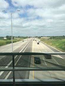
Interstate 90 (I-90) in the U.S. state of Illinois runs roughly northwest-to-southeast through the northern part of the state. From the Wisconsin state line at South Beloit, it heads south to Rockford before heading east-southeast to the Indiana state line at Chicago. I-90 traverses 108 miles (174 km) through a variety of settings, from farmland west of the Fox River Valley through the medium-density suburban west of O'Hare International Airport, through downtown Chicago, and through the heart of the industrial southeast side of Chicago before entering Indiana.
I-90 comprises several named highways. The Interstate runs along the Jane Addams Memorial Tollway from South Beloit to O'Hare Airport, the Kennedy Expressway runs from O'Hare to the Chicago Loop, the Dan Ryan Expressway from the Loop to the Chicago Skyway, and the Skyway to the Indiana state line. The Jane Addams and Chicago Skyway are toll roads maintained by the Illinois State Toll Highway Authority and Skyway Concession Company, respectively. The remainder of the highway is maintained by the Illinois Department of Transportation.
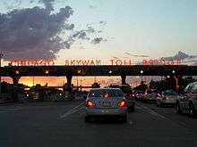
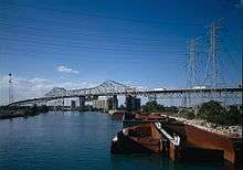
The Chicago Skyway, also known as Chicago Skyway Toll Bridge System, is a 7.8-mile-long (12.6 km) toll road in Chicago carrying I-90 from the Indiana Toll Road to the Dan Ryan Expressway on Chicago's South Side. The main feature of the Skyway is a 1⁄2-mile-long (0.80 km) steel truss bridge, known as the "High Bridge". The toll bridge spans the Calumet River and Calumet Harbor, a major harbor for industrial ships. The main span is 650 feet (200 m) long, provides for 125 feet (38 m) of vertical clearance, and is the highest road in Chicago.
The Jane Addams Tollway was built in the late 1950s and early 1960s as the Northwest Tollway. It was renamed in 2007 after Jane Addams, the Nobel laureate and founder of the Settlement House movement in the United States. Between 2001 and 2004, authorities spent $250 million to rebuild much of the Chicago Skyway.
Route description

I-90 enters from Beloit, Wisconsin with I-39. At the Rockton Road exit, I-39/I-90 becomes the Jane Addams Memorial Tollway. The two Interstates run concurrently south to Rockford, where I-39 continues as a freeway south to Bloomington–Normal. I-90 continues east-southeast to Belvidere and Elgin on the way through the Chicago area. In Schaumburg, I-90 meets the western end of I-290, the only loop from I-90 in Illinois.
I-90 passes north of O'Hare International Airport, where I-190 branches west to the airport terminals. I-90 also meets I-294 at this junction with I-190. I-90 continues southeast as the Kennedy Expressway and is later joined with eastbound I-94; westbound I-94 runs on the Edens Expressway. I-90 and I-94 then head toward the Loop, intersecting the eastern end of I-290. South of I-290, the highway is given the name of the Dan Ryan Expressway.
On Chicago's South Side, the Dan Ryan passes I-55 before I-90 splits off from I-94 just south of 63rd Street, and becomes the Chicago Skyway, again becoming a toll road. I-90 then runs directly southeast to the Indiana state line, and becomes the Indiana Toll Road at the state line.
Directional system
Often confusing to non-residents is the direction system for I-90/94, in which signs that say "I-90/I-94 West" go north–northwest and signs that say "I-90/I-94 East" go south–southeast. This naming system is due to the overall direction of the freeway. Westbound I-90 runs physically northward to Wisconsin and eventually to Seattle. Eastbound I-90 runs physically southward and then turns northeasterly to Boston.
Chicago Skyway designation
| |
|---|---|
| Location: | Chicago |
| Length: | 7.49 mi[1] (12.05 km) |
| Existed: | April 1958–present |
Historically, the Chicago Skyway was signed as, and was widely considered to be part of, I-90 from the mid-1960s forward (after I-90 in this area had been swapped with I-94). However, around 1999, the City of Chicago realized they had never received official approval to designate the Skyway as I-90. The city subsequently replaced most of the "I-90" signage with "TO I-90/I-94" signage. However, the Illinois Department of Transportation (IDOT) has always and continues to report the Skyway as part of the Interstate Highway System, and the Federal Highway Administration also considers the Chicago Skyway an official part of I-90.[2]
The Skyway's official name, referring to it as a "toll bridge" rather than a "toll road", is the result of a legal quirk. At the time of its construction, the city charter of Chicago did not provide the authority to construct a toll road. However, the city could build toll bridges, and it was found that there was no limit to the length of the approaches to the bridge. Therefore, the Skyway is technically a toll bridge with a six-mile-long (9.7 km) approach. This also is part of the reason that there are no exits available until after one has crossed the bridge and paid the toll.[3]
Tolls
Along the Jane Addams Tollway, there are four mainline toll barriers in each direction—two split plazas and two full plazas. The barriers are located around the O'Hare International Airport area (River Road eastbound and Devon Avenue westbound), in Elgin, near Marengo (eastbound), in Belvidere (westbound), and in South Beloit. I-39 travelers exiting or entering at Rockford paid at the Cherry Valley toll plaza, but that toll plaza has been decommissioned southbound in 2003 and northbound in 2004 due to traffic congestion.[4]
In February 2006, the Marengo westbound and the Belvidere eastbound toll plazas were removed. Two two-toll plazas near O'Hare and the one in Elgin each charge cash tolls of $1.50 (as of January 1, 2012) and I-Pass tolls of 75cents for a two-axle passenger vehicle. The South Beloit toll plaza near the Illinois and Wisconsin state line is $1.90 and 95 cents for I-Pass users (formerly $1.00 and 50¢ before 2012). Eastbound traffic does not pay a toll at Belvidere because of the removal of the eastbound Belvidere plaza, but pays $3.00 at Marengo (I-Pass users pay $1.50). On the other hand, westbound traffic pays no toll at Marengo but pays $3.00 at Belvidere (I-Pass users pay $1.50). This change was done to accommodate open road tolling construction. Originally, a ticket system was used to compute tolls on the segment between Beloit and Elgin with each driver receiving a Hollerith card upon entering and paying upon exiting, but it was replaced with a cash barrier system in the late 1970s. It was the only portion of the Illinois Tollways to use a ticket system.
The current rate for passenger cars and other two-axle vehicles on the Chicago Skyway is $4.50; vehicles with more axles pay higher rates. A discount is given during the overnight hours for vehicles with three or more axles.[5]
Services
One Oasis on the Jane Addams Tollway is sited at Belvidere, an over-highway oasis. This unique rest stop provides several vendors and allows tollway travels to rest, refuel, and eat without having to exit the tollway. Another oasis was previously sited in Des Plaines near O'Hare, but it was closed and demolished in 2014 to make room for the widening of I-90 and the O'Hare West Bypass.[6] A welcome center is located south of Beloit, Wisconsin, that is located on the IDOT portion of the highway between the border with Wisconsin and Illinois tollway control.
At the Chicago Skyway's toll plaza, a McDonald's was at highway grade in the road's median until July 2015.[7]
Golden Corridor
From O'Hare to Huntley, the region around the Jane Addams Tollway is sometimes referred to as the "Golden Corridor", due to the proximity of commercial and business activity located along the corridor in northwest suburban Chicago. A number of Fortune 500 companies, large malls, hotels, entertainment and exhibition facilities, restaurants, and retailers are located along the corridor.
History
Jane Addams Memorial Tollway
The 76-mile (122 km) Northwest Tollway portion of I-90 opened on August 20, 1958.[8] Prior to the opening, the first vehicle to officially travel the new roadway was a covered wagon navigated by local resident John Madsen who took 5 days to make the journey.[9]
On September 7, 2007, the Northwest Tollway was renamed the Jane Addams Memorial Tollway after Jane Addams, the Nobel Peace Prize winner and founder of the Settlement House movement in the United States.[10][11]
The Illinois Tollway's 2005–2012 Congestion-Relief Program provided $644.1 million in improvements to the I-90 corridor.[12] The most prominent projects were the reconstruction of the I-90/I-39 interchange to improve traffic flow and reconstructing and widening the tollway to six lanes between I-39 and Rockton Road. This construction started in 2008 and was completed by the end of 2009.[13]
As part of the Tollway's $12 billion capital program, Move Illinois, over US$2 billion will be spent on improving the Jane Addams Memorial Tollway (I-90). Projects include rebuilding and widening the roadway to six lanes between I-39 and Randall Road, and eight lanes between Randall Road and the Kennedy Expressway. The inside shoulders will be widened for future transit opportunities, and active traffic management will be incorporated into the corridor.[14][15] In addition, almost all of the crossroad bridges will be rebuilt and several interchanges will be reconfigured/expanded.[16]
Chicago Skyway
The Chicago Skyway was originally known as the Calumet Skyway.[17] It cost $101 million (1958, $791 million in 2011) to construct and took about 34 months (nearly 3 years) to build. Nearly 8 miles (13 km) of elevated roadway, the Chicago Skyway was originally built as a shortcut from State Street, a major north-south street on Chicago's South Side that serves the Loop, to the steel mills on the Southeast to the Indiana state line where the Indiana Toll Road begins. Later, when the Dan Ryan Expressway opened, the Chicago Skyway was extended west to connect to it. There are only two eastbound exits east of the toll barrier, whereas there are four westbound exits west of the toll barrier (so that no exits are available until one has crossed the bridge and paid the toll). The Chicago Skyway opened to traffic on April 16, 1958.[17][18]
In the 1960s, the newly constructed Dan Ryan Expressway and the neighboring Calumet Expressway, Kingery Expressway and Borman Expressway provided free alternatives to the tollway, and the Skyway became much less used. As a result, from the 1970s through the early 1990s, the Skyway was unable to repay revenue bonds used in its construction.[19]
Traffic volumes have rebounded in recent years, (to 47,700 vehicles per day)[20] partially because of the construction of casinos in Northwest Indiana, along with re-construction of the Dan Ryan, Kingery and Borman Expressways. The city of Chicago claims a record number of motorists used the Skyway in 2002.
In 2003 and 2004, the city of Chicago initiated a $250 million project to rehabilitate and widen the Skyway. The project involved extensive work on the cantilever span and its approaches that included replacing the bridge's structural steel, rebuilding the piers that support the structure, and reconstructing the bridge deck. Because the city of Chicago required the Skyway to remain open during construction, engineers had to construct temporary bridge piers that would bear the load of the bridge and its traffic while new piers were built. The bridge was lifted up onto the temporary piers using 600 ton hydraulic jacks, the old piers were removed, and new ones were built. Crews also devised innovative methods for replacing the bridge's structural steel, replacing steel members one at a time. This process involved installing hydraulic chords around the component to be replaced. The bridge load was then transferred to the hydraulic chord, the steel member was removed and a new steel member was then installed.[21]
In June 2005, the Skyway became compatible with electronic toll collection, with users now able to pay tolls using I-PASS or E-ZPass transponders. There is no discount for using a transponder.
The city of Chicago's Department of Streets and Sanitation formerly maintained the Chicago Skyway Toll Bridge System. A transaction that gave the city of Chicago a $1.83 billion cash infusion leased the Skyway to the Skyway Concession Company (SCC), a joint-venture between the Australian Macquarie Infrastructure Group and Spanish Cintra Concesiones de Infraestructuras de Transporte S.A., which assumed operations on the Skyway on a 99–year operating lease. SCC will be responsible for all operating and maintenance costs of the Skyway but has the right to all toll and concession revenue. The Triple-A bond insurer Financial Security Assurance Inc. (FSA) has guaranteed $1.4 billion of senior bonds to provide long-term funding for the privately operated Chicago Skyway. On June 30, 2006, this same joint-venture assumed responsibility for operating and maintaining the adjacent Indiana East–West Toll Road for $3.8 billion. The agreement between SCC and the city of Chicago marked the first time an existing toll road was moved from public to private operation in the United States.[22]
Exit list
| County | Location | mi[1] | km | Exit | Destinations | Notes |
|---|---|---|---|---|---|---|
| Winnebago | South Beloit | 0.00 | 0.00 | Continuation into Wisconsin | ||
| 0.29 | 0.47 | 1 | Western end of US 51 overlap | |||
| Rockton | 2.71 | 4.36 | 3 | Northwestern end of Jane Addams Memorial Tollway | ||
| 3.60 | 5.79 | South Beloit Toll Plaza | ||||
| Rockford | 8.94 | 14.39 | 9 | |||
| 12.47 | 20.07 | 12 | East Riverside Boulevard – Loves Park | |||
| 15.76 | 25.36 | 15 | ||||
| 17.40 | 28.00 | 17 | Eastern end of I-39 / US 51 overlap. To Chicago Rockford International Airport via US 20 West | |||
| Boone | Belvidere | 20.40 | 32.83 | 21 | Irene Road | |
| 22.93 | 36.90 | Belvidere Toll Plaza (westbound) | ||||
| 23.51 | 37.84 | Belvidere Tollway Oasis | ||||
| 24.62 | 39.62 | 25 | Belvidere–Genoa Road – Belvidere | |||
| McHenry | Riley | 37.39 | 60.17 | Marengo Toll Plaza (eastbound) | ||
| Kane | Hampshire | 41.54 | 66.85 | 42 | ||
| Huntley | 46.02 | 74.06 | 47 | |||
| Elgin | 51.78 | 83.33 | 52 | |||
| 53.42 | 85.97 | Elgin Toll Plaza | ||||
| 54.22 | 87.26 | 54 | ||||
| Kane–Cook county line | 55.95 | 90.04 | 56 | |||
| Cook | Hoffman Estates | 57.77 | 92.97 | 58 | Beverly Road | Westbound exit and eastbound entrance only |
| 59.31 | 95.45 | 59 | ||||
| 61.81 | 99.47 | 62 | Barrington Road | Interchange under construction; expected to be completed in Spring 2017 | ||
| Schaumburg | 65.19 | 104.91 | 65 | Roselle Road | Westbound entrance to open in 2017 | |
| 66.93 | 107.71 | 67 | Meacham Road | Westbound exit and entrance only | ||
| 67.84 | 109.18 | 68 | To I-355 (Veterans Memorial Tollway); to IL 390 (formerly the Elgin-O'Hare Expressway) | |||
| Arlington Heights | 70.47 | 113.41 | 70 | Arlington Heights Road | ||
| Des Plaines | 73.25 | 117.88 | 73 | Elmhurst Road | Full interchange to open in 2017; to IL 83 | |
| 75.80 | 121.99 | 76 | Westbound exit and eastbound entrance only | |||
| Rosemont | 76.75 | 123.52 | Devon Avenue Toll Plaza (westbound) | |||
| 77.03 | 123.97 | — | Westbound entrance only | |||
| 77.20– 78.65 | 124.24– 126.57 | 77/78 | ||||
| 78.20 | 125.85 | River Road Toll Plaza (eastbound) | ||||
| Chicago | 78.49 | 126.32 | Southeastern end of Jane Addams Memorial Tollway Northwestern end of Kennedy Expressway | |||
| 79.28 | 127.59 | 79 | Signed as exits 79A (south) and 79B (north) | |||
| 79.99 | 128.73 | 80 | Canfield Road | Westbound exit and eastbound entrance only | ||
| 80.84 | 130.10 | 81A | ||||
| 81.14 | 130.58 | 81B | Sayre Avenue | Westbound exit and eastbound entrance only | ||
| 81.85 | 131.72 | 82A | Nagle Avenue | No westbound exit | ||
| 82.09 | 132.11 | 82B | Bryn Mawr Avenue | Westbound exit only | ||
| 82.31 | 132.47 | 82C | Austin Avenue | Eastbound exit only | ||
| 82.79 | 133.24 | 83A | Foster Avenue | No eastbound exit | ||
| 83.01 | 133.59 | 83B | Central Avenue | Westbound exit and eastbound entrance only | ||
| 83.71 | 134.72 | 84 | Lawrence Avenue | Eastbound To I-94 | ||
| 84.35– 84.59 | 135.75– 136.13 | — | Western end of I-94 overlap; westbound exit and eastbound entrance only; western end of reversible express lanes | |||
| 84.77 | 136.42 | 43C | Montrose Avenue | Westbound exit and eastbound entrance only | ||
| 85.03 | 136.84 | 43D | Kostner Avenue | Westbound exit only | ||
| 85.39– 85.62 | 137.42– 137.79 | 44A | No westbound exit | |||
| 85.62– 85.81 | 137.79– 138.10 | 44B | Westbound exit and eastbound entrance only | |||
| 86.34 | 138.95 | 45A | Addison Street | |||
| 86.77 | 139.64 | 45B | Kimball Avenue | |||
| 87.08 | 140.14 | 45C | Belmont Avenue | Westbound exit and eastbound entrance only | ||
| 87.64 | 141.04 | — | Sacramento Avenue | Eastbound entrance only | ||
| 87.79 | 141.28 | 46A | California Avenue | Eastbound exit and westbound entrance only | ||
| 87.96 | 141.56 | 46B | Diversey Avenue | Westbound exit and eastbound entrance only | ||
| 88.53– 88.90 | 142.48– 143.07 | 47A | Western Avenue, Fullerton Avenue | Westbound exit and eastbound entrance from Western Avenue | ||
| 89.08 | 143.36 | 47B | Damen Avenue | Westbound exit and eastbound entrance only | ||
| 89.52 | 144.07 | 48A | Armitage Avenue | Eastbound traffic uses Armitage Avenue to Ashland Avenue | ||
| 90.10 | 145.00 | 48B | Westbound traffic uses North Avenues to Ashland Avenue | |||
| 90.66 | 145.90 | 49A | Division Street | |||
| 90.91 | 146.31 | 49B | Augusta Boulevard, Milwaukee Avenue | Westbound exit and eastbound entrance only | ||
| 91.40 | 147.09 | 50A | Ogden Avenue | Eastbound exit and westbound entrance only | ||
| 91.62 | 147.45 | 50B | Ohio Street | Eastern end of reversible express lanes | ||
| 92.19 | 148.37 | 51A | Lake Street | Westbound exit and eastbound entrance only | ||
| 92.27 | 148.49 | 51B | Randolph Street west | |||
| 92.34 | 148.61 | 51C | Washington Boulevard east | Exits only; no entrances | ||
| 92.44 | 148.77 | 51D | Madison Street | |||
| 92.53 | 148.91 | 51E | Monroe Street | Eastbound exit only | ||
| 92.62 | 149.06 | 51F | Adams Street west | Eastbound exit and westbound entrance only | ||
| 92.71 | 149.20 | 51G | Jackson Boulevard east | Eastbound exit and westbound entrance only | ||
| 92.72– 93.35 | 149.22– 150.23 | 51H 51I | Congress Parkway – Chicago Loop | Circle Interchange; signed as exits 51H (west) and 51I (east); southeastern end of Kennedy Expressway and northern end of Dan Ryan Expressway | ||
| 93.42 | 150.34 | 52A | Taylor Street, Roosevelt Road | Eastbound exit and westbound entrance only | ||
| 93.57 | 150.59 | 52B | Roosevelt Road, Taylor Street | Westbound exit and eastbound entrance only | ||
| 94.22 | 151.63 | 52C | 18th Street | Eastbound exit and westbound entrance only | ||
| 94.22– 96.04 | 151.63– 154.56 | 53B 53C | Signed as exits 53B (south) and 53C (north) westbound; Cermak Road access from westbound only; western end of express lanes | |||
| 94.48 | 152.05 | 53A | Canalport Avenue, Cermak Road | Westbound exit and eastbound entrance only; Chinatown exit | ||
| 96.16 | 154.75 | 54 | 31st Street | |||
| 96.45 | 155.22 | 55A | 35th Street | U.S. Cellular Field, Illinois Institute of Technology | ||
| 96.98 | 156.07 | 55B | Pershing Road | |||
| 97.44 | 156.81 | 56A | 43rd Street | |||
| 97.97 | 157.67 | 56B | 47th Street | |||
| 98.88 | 159.13 | 57 | Garfield Boulevard | |||
| 99.50 | 160.13 | 58A | 59th Street | Westbound exit and eastbound entrance only | ||
| 100.00 | 160.93 | 58B | 63rd Street | Eastbound exit and westbound entrance only | ||
| 100.00– 100.33 | 160.93– 161.47 | — | Eastern end of I-94 overlap; eastern end of express lanes; western end of Chicago Skyway | |||
| 100.33 | 161.47 | 100 | State Street | Westbound exit and eastbound entrance only | ||
| 101.42 | 163.22 | 101 | St. Lawrence Avenue | Westbound exit and eastbound entrance only | ||
| 101.78 | 163.80 | 102 | 73rd Street | Westbound exit and eastbound entrance only | ||
| 103.04– 103.33 | 165.83– 166.29 | 103 | Stony Island Avenue to Lake Shore Drive | Westbound exit and eastbound entrance only | ||
| 103.93 | 167.26 | — | Jeffery Boulevard, 84th Street | Eastbound entrance only | ||
| 104.28 | 167.82 | 104 | 87th Street | Westbound exit | ||
| 104.67 | 168.45 | Chicago Skyway Toll Plaza | ||||
| 105.26 | 169.40 | 105 | Anthony Avenue, 92nd Street | Eastbound exit and westbound entrance only | ||
| 105.82– 106.21 | 170.30– 170.93 | Chicago Skyway Toll Bridge | ||||
| 107.82 | 173.52 | 107 | Eastbound exit and westbound entrance only | |||
| Continuation into Indiana; eastern end of Chicago Skyway | ||||||
1.000 mi = 1.609 km; 1.000 km = 0.621 mi
| ||||||
Related routes
- I-190 - a spur into O'Hare International Airport in Chicago.
- I-290 - a southwest dogleg left route accessing the west suburbs and heading east into downtown Chicago. Also known as the Eisenhower Expressway.
See also
References
- 1 2 3 "Illinois Technology Transfer Center" (ESRI shapefile). Illinois Department of Transportation. 2011. Retrieved 2013-02-18.
- ↑ Samuel, Peter (June 29, 2005). "Skyway is Interstate-90 unless state withdraws reports - Feds". TOLLROADSnews. Retrieved 2010-01-03.
- ↑ Mayer, Harold M.; Wade, Richard C. (1969). Chicago: Growth of a Metropolis. Chicago: University of Chicago Press. p. 442. ISBN 0-226-51274-6.
- ↑ "Cherry Valley Interchange Press Release". November 12, 2009. Retrieved 2009-11-13.
- ↑ Staff. "Chicago Skyway: Tolls". Skyway Concession Company. Retrieved 2013-01-10.
- ↑ "Jane Addams Memorial Tollway (I-90) - www.illinoistollway.com". Retrieved 2014-10-04.
- ↑ "Skyway McDonalds Closes, Chicago Reacts". Chicago: WMAQ-TV. July 12, 2015. Retrieved 2015-07-13.
- ↑ "N. W. Tollway Opens Aug. 20 at Ceremony". Chicago Daily Tribune. June 30, 1958. Retrieved 2010-04-18.
- ↑ "First tollway vehicle to be covered wagon". The Milwaukee Journal. August 11, 1958. Retrieved 2010-04-18.
- ↑ Ryan, Joseph (September 7, 2007). "Northwest Tollway renamed for reformer Addams". Retrieved 2007-09-08.
- ↑ Illinois General Assembly (May 22, 2007). "Full text of HJR0019". Retrieved 2007-09-08.
- ↑ Staff (2011). Congestion Relief Program: 2011 Update (PDF) (Report). Illinois State Toll Highway Authority. Retrieved 2014-09-19.
- ↑ Staff. "Cherry Valley Interchange (I-90/39) Reconstruction and Reconfiguration" (PDF). Illinois State Toll Highway Authority. Retrieved 2014-09-19.
- ↑ "Transit on I-90" (PDF). Jane Addams Memorial Tollway Rebuilding and Widening Project. Illinois State Toll Highway Authority. Retrieved 2014-09-19.
- ↑ "A Smart, State-of-the-Art, 21st Century Corridor" (PDF). Jane Addams Memorial Tollway Rebuilding and Widening Project. Illinois State Toll Highway Authority. Retrieved 2014-09-19.
- ↑ "New and Improved Interchanges" (PDF). Jane Addams Memorial Tollway Rebuilding and Widening Project. Illinois State Toll Highway Authority. Retrieved 2014-09-19.
- 1 2 Foust, Hal (April 17, 1958). "A Great Day For Chicago! Skyway Open". Chicago Tribune. Retrieved 2010-06-21.(subscription required)
- ↑ Staff. "System Facilities". Chicago Area Transportation Study. Retrieved 2007-07-07.
- ↑ McClendon, Dennis (2005). "Skyway". Encyclopedia of Chicago. Retrieved 2007-07-07.
- ↑ Staff (2005). "Getting Around Illinois". Illinois Department of Transportation. Retrieved 2007-07-07.
- ↑ Staff. "Chicago Skyway Rehab: Hydraulics Boost Productivity". Enerpac Company. Retrieved 2007-07-07.
- ↑ "Chicago privatizes Skyway toll road in $1.8 billion deal". Southern Illinoisian. Carbondale, IL. Associated Press. October 17, 2004. Retrieved 2008-03-04.
External links
| Wikimedia Commons has media related to |
- Illinois Tollway official site
- Official website of the Chicago Skyway
- Chicago Department of Transportation
- Description and history at Richard Carlson's Illinois Highways
- Historic, Current & Average Travel Times For The Jane Addams Tollway
- Best of Transportation Page
- Chicago Skyway (I-90) at Steve Anderson's ChicagoRoads.com
- Historic American Engineering Record (HAER) No. IL-145, "Chicago Skyway Toll Bridge"
- Chicago Skyway High Bridge at Structurae
| Previous state: Wisconsin |
Illinois | Next state: Indiana |
| Bridges of the Calumet River | ||||
|---|---|---|---|---|
| ||||