John Forrest National Park
| John Forrest National Park Western Australia | |
|---|---|
|
IUCN category II (national park) | |
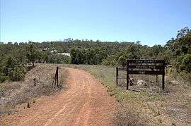 National Park western entrance | |
 John Forrest National Park | |
| Nearest town or city | Perth |
| Coordinates | 31°52′55″S 116°04′26″E / 31.88194°S 116.07389°ECoordinates: 31°52′55″S 116°04′26″E / 31.88194°S 116.07389°E |
| Established | 1957 |
| Area | 26.78 km2 (10.3 sq mi) |
| Managing authorities | Department of Parks and Wildlife (Western Australia) |
| Website | John Forrest National Park |
| See also |
List of protected areas of Western Australia |
John Forrest National Park is a national park in the Darling Scarp, 24 km east of Perth, Western Australia. It was the first national park in Western Australia and the second in Australia after Royal National Park.
Name
As early as 1898, the land was reserved for conservation and recreation. Two years later, it was named Greenmount National Park [1] It was still being identified as National Park in the late 1930s [2][3] and it was not until 1947 that the name change occurred to commemorate Sir John Forrest, the first Premier of Western Australia.[4][5]
Location
The park is on the edge of the Darling Scarp east of Perth, north of the Great Eastern Highway. The suburb to the west is known as Swan View with Pechey Road as a natural western boundary. To the south of the Great Eastern Highway the suburbs adjacent are Darlington and Glen Forrest. To the east Hovea is the adjacent suburb.
History
It was dissected by the Eastern Railway when it was constructed in the 1890s and rail traffic passed through until 1966, when the line was closed due to the opening of the Avon Valley route.[6][7]
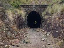
The alignment through the Swan View Tunnel and through the park was commonly known as the 'National Park' railway line.
During the Great Depression of the 1930s many features near the main park buildings were built as part of relief employment. Some have been restored. It also has a tavern.
It was a very popular railway excursion location while the railway was in existence (1890s to 1960s).[8] Initially Hovea was the nearest railway station but in 1936 the National Park railway station was built. Also often photographed were National Park Falls, and the Hovea Falls.
After the railway line was closed and removed the formation became part of the Railway Reserves Heritage Trail vested in the Mundaring Shire Council. The section within the park is now known as the John Forrest Heritage Trail. There are also the Glen Brook Walk Trail and the Eagle View Walk Trail within the park.
Current conditions
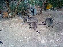
While larger kangaroos remain, significant populations of smaller marsupials have been decimated by foxes, feral cats and dogs in this park.
Drought and dieback have affected the jarrah forest within the park. At the edges of the park, introduced species of weed, and problematic vegetation threaten the integrity of the park. In some areas wildflowers remain a feature to the edge of the internal roads despite the changes [9]
Also with rationalising of staff within the Department of Environment and Conservation management, earlier levels of staffing on parks such as this one has been reduced to minimal levels.
Significant damaging bushfires occurred in the western and northern sections of the park in the 1990s and early 2000s. In November 2010 a bushfire, believed to have been deliberately lit, damaged a significant area of the park including part of the Eagle's View trail.
At various stages parts of the park have been accessed by mountain bike activity [10]
See also
Notes
- ↑ "Greenmount National Park.". Swan Express. XXVI, (78). Western Australia. 6 August 1926. p. 4. Retrieved 3 November 2016 – via National Library of Australia.
- ↑ State Gardens Board of Western Australia (1939), Beautiful National Park : Darling Range, Western Australia, The Board, retrieved 3 November 2016
- ↑ "BEAUTIFUL NATIONAL PARK". Sunday Times (Perth) (2027). Western Australia. 29 November 1936. p. 11. Retrieved 3 November 2016 – via National Library of Australia.
- ↑ Nevill, Simon (2001). Travellers guide to the Parks and Reserves of Western Australia. Simon Nevill Publications. ISBN 0-9585367-1-6.
- ↑ "NATIONAL PARK RENAMED". The West Australian. 63, (19,076). Western Australia. 4 September 1947. p. 15 (SECOND EDITION.). Retrieved 3 November 2016 – via National Library of Australia.
- ↑ Watson, Lindsay (Lindsay Graham); Swan (W.A.). Council; Western Australian Light Railway Preservation Association; L. & S. Drafting (1995), The railway history of Midland Junction : commemorating the centenary of Midland Junction, 1895-1995, L & S Drafting in association with the Shire of Swan and the Western Australian Light Railway Preservation Association, ISBN 978-0-646-24461-7
- ↑ Elliot, Ian; Elliot, Ian (1983), Mundaring : a history of the shire, Shire of Mundaring, ISBN 978-0-9592776-0-9 - has a specific chapter relating to the railway in the hills
- ↑ "EXCURSION TO NATIONAL PARK.". The West Australian. 55, (16,605). Western Australia. 21 September 1939. p. 6. Retrieved 3 November 2016 – via National Library of Australia.
- ↑ Armstrong, P; Muir, B (1988-04), "Visual perception of conservation value: the distribution of flora in John Forrest National Park. -Western Australia-", Journal of Environmental Management, 26 (3): 221–228, retrieved 3 November 2016 Check date values in:
|date=(help) - ↑ Davies, C; Newsome, D (2009), Mountain bike activity in natural areas: impacts, assessment and implications for management: a case study from John Forrest National Park, Western Australia, CRC for Sustainable Tourism, retrieved 3 November 2016
External links
| Wikimedia Commons has media related to John Forrest National Park. |
- John Forrest National Park page at the Department of Parks and Wildlife website