Johns Hopkins Glacier
| Johns Hopkins | |
|---|---|
|
Johns Hopkins Glacier with Mount Orville and Mount Wilbur in the background | |
 Glacier Bay National Park and Preserve, Alaska, United States | |
| Type | Tidewater |
| Coordinates | 58°48′24″N 137°15′01″W / 58.80667°N 137.25028°WCoordinates: 58°48′24″N 137°15′01″W / 58.80667°N 137.25028°W[1] |
| Length | 12-mile (19 km) |
| Terminus | Johns Hopkins Inlet |
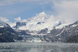
Johns Hopkins Glacier is a 12-mile (19 km) long glacier located in Glacier Bay National Park and Preserve in the U.S. state of Alaska. It begins on the east slopes of Lituya Mountain and Mount Salisbury, and trends east to the head of Johns Hopkins Inlet, 1 mile (1.6 km) southwest of the terminus of Clark Glacier and 79 miles (127 km) northwest of Hoonah. It was named after Johns Hopkins University in Baltimore, Maryland in 1893 by Harry Fielding Reid.[1] It is one of the few advancing tidewater glaciers of the Fairweather Range.[2] Access to the face of the glacier is limited to the Johns Hopkins Inlet.[3]
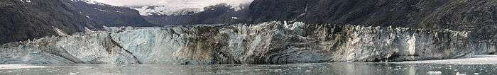
Terminus of Johns Hopkins Glacier
See also
References
- 1 2 "Johns Hopkins Glacier". Geographic Names Information System. United States Geological Survey.
- ↑ Lawson, Daniel E. "An Overview of Selected Glaciers in Glacier Bay" (PDF). National Park Service. Retrieved October 16, 2014.
- ↑ "Johns Hopkins Glacier: One of Few Advancing Glacier". alaska.org. Retrieved October 16, 2014.
This article is issued from Wikipedia - version of the 4/6/2016. The text is available under the Creative Commons Attribution/Share Alike but additional terms may apply for the media files.