Jotunheimen
| Jotunheimen | |
|---|---|
 View from Galdhøpiggen | |
| Highest point | |
| Elevation | 2,469 m (8,100 ft) |
| Geography | |
| Country | Norway |
| County | Sogn og Fjordane and Oppland |
| Range coordinates | 61°38′N 8°18′E / 61.63°N 8.3°ECoordinates: 61°38′N 8°18′E / 61.63°N 8.3°E |
| Parent range | Scandinavian Mountains |
| Geology | |
| Orogeny | Caledonian orogeny |
Jotunheimen (Norwegian pronunciation: [ˈjuːtʉnˌhæɪmən], the home of the Jotnar) is a mountainous area of roughly 3,500 km² in southern Norway and is part of the long range known as the Scandinavian Mountains. The 29 highest mountains in Norway are all in Jotunheimen, including the very highest - Galdhøpiggen (2469 m). Jotunheimen straddles the border between the counties of Oppland and Sogn og Fjordane.
Jotunheimen contains Jotunheimen National Park, which was established in 1980 and covers an area of 1,151 km².[1] The Hurrungane mountain range is also inside the national park with the sharpest peaks in Jotunheimen. Adjacent to the national park border is Utladalen Nature Reserve which covers the Utladalen valley and the mountain Falketind, amongst others.
Jotunheimen is very popular with hikers and climbers, and the Norwegian Mountain Touring Association maintains a number of mountain lodges in the area, as well as marked trails that run between the lodges and others that run up to some of the peaks.
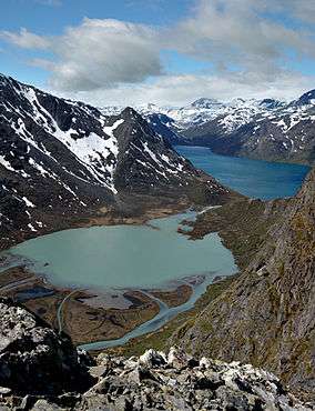
The image from Gjende shows a cliff trailing down into the lake. At its base there is a popular guest house called Memurubu. The picture is taken from Gjendesheim, a starting point for hiking into the mountain range. There is a very popular trail along Besseggen that follows the edge of the mountainous range to the right, which it is named after.
There is a National Tourist Route, the Sognefjell Road, from Skjolden to Lom and another road, the RV 51, from Gol to Vågå through the special area of Valdresflya.
The name
Originally there was no common name for this large mountainous area, however in 1820 the Norwegian geologist and mountaineer, Baltazar Mathias Keilhau proposed the name Jotunfjeldene "the mountains of the Jotnar" (inspired by the German name Riesengebirge). This was later changed to Jotunheimen by the poet Aasmund Olavsson Vinje in 1862 - this name/form was directly inspired by the name Jötunheimr in Norse mythology.
Human presence
The Jotunheimen shoe was discovered in August 2006. Archaeologists estimate that the leather shoe was made between 1800 and 1100 BCE,[2] making it the oldest article of clothing discovered in Scandinavia. It was discovered along with several arrows and a wooden spade, leading archaeologists to conclude that they had unearthed an important hunting ground.
See also
References
External links
| Wikivoyage has a travel guide for Jotunheimen. |
| Wikimedia Commons has media related to Jotunheimen. |
- Jotunheimen website
- Tilltopps - Hiking in Jotunheimen.
- Photos of Jotunheimen
- Map
- Sognefjell Road
- Jotunheimen in pictures
- The Jotunheimen Mountains - the official travel guide to Norway
