Juanita, Washington
| Juanita, Washington | |
|---|---|
| Neighborhood | |
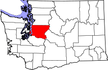
 Location of Juanita within King County, Washington, and King County within Washington. | |
| Coordinates: 47°41′9″N 122°11′30″W / 47.68583°N 122.19167°W | |
| Country | United States |
| State | Washington |
| County | King |
| Elevation | 14–500 ft (4–152 m) |
| Time zone | Pacific (UTC-8) |
| • Summer (DST) | Pacific (UTC-7) |
| ZIP codes | 98033, 98034, 98083 |
| Area code(s) | 425 |
| FIPS code | 53-35940[1] |
| GNIS feature ID | 1512352[2] |
Juanita, Washington is an area of King County located in the city of Kirkland[3] along the northeast edge of Lake Washington. In December 2009, its annexation to Kirkland was approved by voters.[4]
History
Juanita Bay was first home to members of the Duwamish tribe, who occupied a village at the mouth of Juanita Creek in today's Juanita Beach Park. The village was known as TUHB-tuh-byook'w, Duwamish jargon for 'Loamy Place' after the composition of the soil, known as loam. The bay was a popular place to harvest Wapatoes, a type of aquatic potato.[5]
A small village sprang up in the 1890s when Martin W. Hubbard, who had lived with his family on the hill east of the area since the 1870s, constructed a dock on the lake shore. The village was named Hubbard, after him. A post office was established, with Hubbard as postmaster, which required him to transfer mail between Seattle and Juanita by rowboat. Dorr Forbes, a civil war veteran, settled in Kirkland in 1877.[6] After living on his original claim at Forbes Lake (then known as Kirkland Lake) on Rose Hill, he relocated to the Juanita area in the mid-1880s where he established a small shingle mill in what is now Forbes Park, roughly three blocks north of the waterfront. Prior to the mill, there was little demand for lumber and trees were simply burned to clear land. A dam was built across Juanita Creek in order to form a log pond for the mill. After a Dry kiln was installed at the mill in 1894, it burned to the ground and was not rebuilt.[6] Harry Langdon, son of 1877 pioneer Roland Langdon, established the community's first store. Dairy and agriculture farms began to gradually take the place of the cleared forests and several gravel pits that served the City of Seattle were operated in the area in the 1910s and 1920s. The lowering of Lake Washington in 1915 shrunk the size of Juanita Bay considerably.[6]
The area found new life in the 1920s as a resort community for Seattleites with the establishment of the Juanita Beach Resort. A new post office was established in 1921 under the name Juanita though the inspiration for the name remains a mystery. The town was given another boost in the 1920s with the construction of Lake Washington Boulevard, also known as highway 2-A, through Juanita. Businesses catering to the automobile were some of the first to appear along the road in Juanita. The Juanita Sanitarium, purchased by Fairfax Hospital of Seattle in 1938, opened in the mid-1920s to treat mental health patients. In 1928, a newly expanded and rebuilt Juanita Beach opened for tourists. Its new attractions included a two story bath house and an amusement Park. A plan was proposed in 1946 to turn the beach into a state park but was shot down for fears that it would ruin business. In 1950 a new larger Juanita school was built to replace the small wooden one. In 1953, Juanita's beaches had to be closed for over a month due to pollution, a problem which has plagued the beach even today.
A new post office opened in 1960 followed by the area's first suburban shopping center and bank in 1963. As the farms and large homesteads around Juanita gave way to subdivisions in the 1960s, the village began to look into incorporation while neighboring Kirkland was looking to annex the area. Juanita became a part of the city of Kirkland in July 1967. The post office closed in 1970.
Geography
The city of Kirkland, in its annexation proposals, defined the "Juanita Neighborhood" as a rough square with NE 145th Street to the north, I-405 to the east, NE 132nd Street to the south and 100th Avenue NE to the west. In more colloquial usage, it sometimes includes the areas extending along Juanita Bay toward Forbes Creek, including Juanita Elementary School, Juanita High School, Juanita Beach and Juanita Bay Park to the south, and the area around the Juanita Drive corridor to the west, defined by Kirkland's annexation plans as the Finn Hill neighborhood.
Recreation
Though primarily residential, Juanita is home of or neighbour to a number of parks. These include:
- Juanita Bay Park
- Juanita Beach
- Heronfield Wetlands (located in pre-annexation Kirkland city limits)
- Edith Moulton Park and Windsor Vista (in the Juanita neighborhood)
- Juanita Woodlands
- O.O. Denny Park
- Big Finn Hill Park
- Saint Edward State Park (in the Finn Hill Neighborhood, but located within Kenmore city limits)
Transportation
The major arterials in Juanita are 100th Avenue NE, Juanita Drive, and NE 132nd Street. Juanita is served by several Metro bus lines.[7]
References
- ↑ "American FactFinder". United States Census Bureau. Retrieved 2008-01-31.
- ↑ "US Board on Geographic Names". United States Geological Survey. 2007-10-25. Retrieved 2008-01-31.
- ↑
- ↑ City Council Accepts Annexation, City of Kirkland, December 16, 2009, retrieved 2010-01-01
- ↑ "Coast Salish Villages of Puget Sound-Duwamish-Seattle" Retrieved August 8, 2010.
- 1 2 3 McDonald, Lucile, "Juanita Once Was Named Hubbard", Seattle Times, 16 Oct, 1955, pg.101
- ↑ Juanita Neighborhood bus routes, King County Metro, retrieved 2010-01-01
Coordinates: 47°39′39″N 122°12′21″W / 47.66083°N 122.20583°W
Municipalities and communities of King County, Washington, United States | ||
|---|---|---|
| Cities |
|  |
| Towns | ||
| CDPs |
| |
| Unincorporated communities | ||
| Indian reservation | ||
| Ghost towns | ||
| Footnotes | ‡This populated place also has portions in an adjacent county or counties | |
 |
Kenmore | Kenmore | Bothell | |
| Lake Washington | |
Woodinville | ||
| ||||
| | ||||
| Lake Washington | Kirkland | Kirkland |