Juniata Formation
| Juniata Formation Stratigraphic range: Ordovician | |
|---|---|
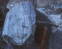
 Outcrop on U.S. Route 522 at Blacklog Narrows southeast of Orbisonia, Pennsylvania. | |
| Type | sedimentary |
| Underlies | Tuscarora Formation |
| Overlies | Bald Eagle Formation |
| Thickness | 400 to 1125 ft |
| Lithology | |
| Primary | sandstone, siltstone, shale |
| Location | |
| Region | Appalachian Mountains |
| Extent | Pennsylvania, Maryland, Virginia, West Virginia, and eastern Tennessee |
| Type section | |
| Named for | Juniata River in Pennsylvania |
| Named by | Darton and Taff[1] |
The Ordovician Juniata Formation is a mapped bedrock unit in Pennsylvania and Maryland. It is a relative slope-former occurring between the two prominent ridge-forming sandstone units: the Tuscarora Formation and the Bald Eagle Formation in the Appalachian Mountains.
Description
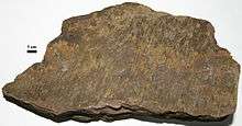
The Juniata is defined as a grayish-red to greenish-gray, thin- to thick-bedded siltstone, shale, and very fine to medium-grained crossbedded sandstone or subgraywacke and protoquartzite with interbedded conglomerate.[2][3] The Juniata is a lateral equivalent of the Queenston Shale in western Pennsylvania.
Depositional environment
The depositional environment of the Juniata has always been intrepreted as mostly terrestrial or shallow marine deposits resulting in a molasse sequence produced by the Taconic orogeny.
Fossils
Very few fossils exist in the Juniata Formation, but different types of trace fossils such as tracks and burrows can commonly be found.
Age
Relative age dating of the Juniata places it in the Upper Ordovician period, being deposited between 488.3 and 443.7 (±10) million years ago. It rests conformably atop the Bald Eagle Formation in Pennsylvania and the Martinsburg Formation in Maryland,[3] and conformably below the Tuscarora Formation.[4]
Economic Uses
The Juniata is a good source of road material, riprap and building stone.[5]
References
- ↑ Darton, N.H., and Taff, J.A., 1896, Description of the Piedmont sheet (West Virginia-Maryland): U.S. Geological Survey Geologic Atlas of the United States, Piedmont folio, no. 28, 6 p.
- ↑ Berg, T.M., Edmunds, W.E., Geyer, A.R. and others, compilers, (1980). Geologic Map of Pennsylvania: Pennsylvania Geologic Survey, Map 1, scale 1:250,000.
- 1 2 "Allegheny Plateau and Valley and Ridge". Geologic Map of Maryland. Maryland Geological Survey. 1968. Retrieved 2008-01-26.
- ↑ Berg, T.M., et al., (1983). Stratagraphic Correlation Chart of Pennsylvania: G75, Pennsylvania Geologic Survey, Harrisburg, Pennsylvania.
- ↑ Doden, Arnold G.; Gold, David P. (2008). "Bedrock Geologic Map of The Mc Alevys Fort Quadrangle, Huntingdon, Centre, and Mifflin Counties, Pennsylvania" (pdf). Pennsylvania Geological Survey.