Juraguá
| Juraguá | |
|---|---|
| Village | |
|
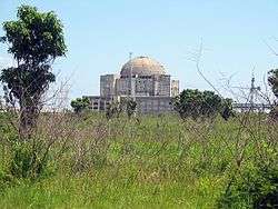
View of the nearby Juragua Nuclear Power Plant | |
.png) OSM map showing Juraguá and its surrounding area. The nearby nuclear plant, the Jagua Fortress, the village of Nueva Juraguá and a bit of the city of Cienfuegos, are shown in the map | |
 Location of Juraguá in Cuba | |
| Coordinates: 22°05′52.1″N 80°33′24.4″W / 22.097806°N 80.556778°WCoordinates: 22°05′52.1″N 80°33′24.4″W / 22.097806°N 80.556778°W | |
| Country |
|
| Province | Cienfuegos |
| Municipality | Abreus |
| Founded | 1849[1] |
| Elevation | 30 m (100 ft) |
| Population | |
| • Total | ca. 7,000 |
| Time zone | EST (UTC-5) |
| Area code(s) | +53-432 |
Juraguá is a Cuban village and consejo popular ("people's council", i.e. hamlet) of the municipality of Abreus, in Cienfuegos Province. With a population of ca. 7,000[2] it is the most populated village in the municipality after Abreus.
History
The village was founded in 1849 by Tomás Terry Adans as a farm (Central Juraguá)[1] and grew around the homonym henequenera, a plantation of henequen that produces and packages sisal fiber, founded in 1923.[3]
In 1976 Cuba and the Soviet Union signed an agreement to construct two nuclear power reactors near Juraguá, and the constrcution of Juragua Nuclear Power Plant, the only one built in Cuba, started in 1983. Named after the village, but located within Cienfuegos municipal territory, it was not completed and abandoned in 2000.[4][5]
Geography
Located on a peninsula between Cienfuegos Bay and the Caribbean Sea, Juraguá lies near the borders of Matanzas Province at the Zapata Swamp (Cienaga de Zapata). The settlement extends south of a road linking Abreus (24 km north), to the Jagua Fortress (Castillo de Jagua, 11 km east). It is 3 km far from Nueva Juraguá, 5 from Juragua Nuclear Power Plant, 30 from Cienfuegos and Yaguaramas, and 35 from Rodas.[6]
Transport
Juraguá is served by the "Abreus-Jagua", a provincial road linked to the state highway Circuito Sur (CS). An industrial railway, starting in Aguada de Pasajeros and ending at the nuclear plant, crosses the village to the south.
See also
References
- 1 2 (Spanish) History of Abreus on EcuRed
- ↑ Source: Mapa de Carreteras de Cuba (Road map of Cuba). Ediciones GEO, Havana 2011 - ISBN 959-7049-21-X
- ↑ (Spanish) Henequenera de Juraguá on Ecured
- ↑ Patrick E. Tyler (December 18, 2000). "Cuba and Russia Abandon Nuclear Plant, an Unfinished Vestige of the Soviet Era". The New York Times. Retrieved October 2015. Check date values in:
|access-date=(help) - ↑ Robert Windrem (October 21, 2003). "Cuba's unfinished power source". NBC NEWS. Retrieved October 2015. Check date values in:
|access-date=(help) - ↑ 1549201982 Juraguá on OpenStreetMap
External links
![]() Media related to Juraguá at Wikimedia Commons
Media related to Juraguá at Wikimedia Commons
